This discussion has been locked.
You can no longer post new replies to this discussion. If you have a question you can start a new discussion

Better Visibility on Map Screen -Feature Request

After a several year break from Garmin (first using a Wahoo, then a Hammerhead Karoo 2) I’m back to Garmin with the Edge 1040 and I’m loving it! I have a Fr955 and having everything sync up, eliminating the need for an Apple Watch and/or Whoop band is awesome! So first off thanks to the Garmin team for continuing to help push things forward.

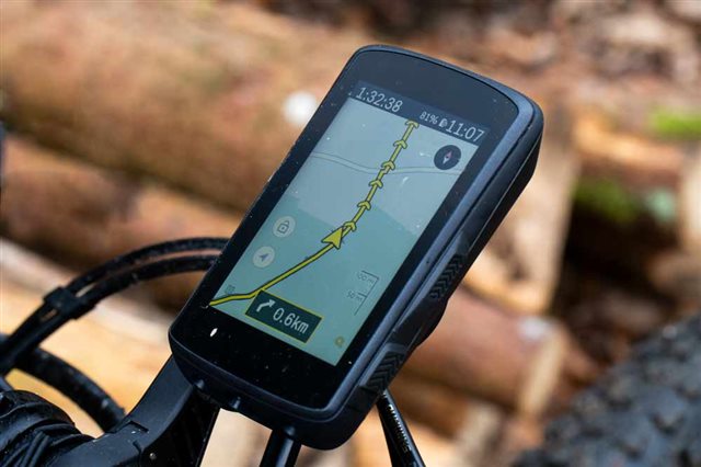
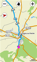
One change I would like to see and I’m hoping others will agree and can upvote or comment here is the visibility of the map, especially when navigating. I race Road, Gravel, and MTB. I find that on the road and really easy gravel the map screen is easy enough to look down long enough to see where you are and what’s ahead, but when riding rougher gravel, higher speed gravel, or MTB in general it is extremely hard to see where you are on the screen and what’s coming up next. I think this is caused a lack in contrast between roads/trails that matter compared to everything else as well as the triangle indicator representing where I am being so small and also a lack of contrast. I’ve added some images of a Wahoo Roam where you can see the navigation path is extremely visible both by contrast and size. I’ve also added an image of the Karoo 2 which has an even larger indicator of your current position and they also make your current route (where you’ve been and where you’re going) drastically stand out simply by using more extreme contrast. I hope this is something we can have changed in the next update.

Note, I am 34 and don’t need perscription glasses, nor am I color blind, sight is totally normal. 

  • In my opinion, the map clarity and accuracy of the maps on my Karoo are still superior to the Garmin. I have used Edge 1000, 1030, 1030+, and now 1040 Solar, and 1040 is better for me to see than the previous editions.

  • I second this.  I moved from the Karoo 2 over to the Edge 1040 Solar.  I love everything about it except for the maps.  I can't see anything.  Especially when trying to find my history line.  I have tried all settings and colors just can't see it.  A great start would be the option to make the history line larger/bolder.

    Also on my Epix 2 watch the map has a dark mode which I personally find much easier to read.  The Edge 1040 has day/night mode but regardless of mode the maps is always the same.  For me personally a dark mode map would create enough contrast to maybe see the history line easier.

  • I'm in my mid fifties, need cheaters. Map page is hard to use. I typically have to stop to focus on hitting zoom buttons etc. Di2 zoom control would be very helpful. Came from 830 thinking bigger screen would help. It doesn't. 

  • Your screenshots are not really comparing apples with apples but some of the things you want are "possible" on the 1040. The location cursor/position symbol color can be changed (but not the size !!!) and the route line color is also changeable both via changing the XML hex color codes in the MapTheme files (in the device Garmin\MapThemes directory).There are a couple of lengthy discussions on these in the various x30 forums, search on MapTheme..

    Personally (and irrationally) I have a deep hatred for the route chevrons, I value being able to actually see the route shape but the chevrons hide too much of the route and tell me nothing I didn't know but many people like them, I would be happy if there was a disable/enable switch for them.

    You can also simplify the map with changes in the "Activity Profile>Navigation>Map>Appearance>Advanced" options (Zoom Levels & Text Size)

    I will do some better examples later today but here is a screenshot I did when experimenting with colors

  • Yeah the images are slightly different scenarios and zoom levels but having used all three I would say they pretty clearly identify the main differences and issues. That’s just my opinion though. 

    I personally don’t really care about the chevrons either way, for me it’s more about the contrast between the route and other trails and/or roads. Color helps with the contrast but when the other streets are still very bold it makes the route hard to distinguish at a glance from other streets, even with color and/or zoomed in. Same goes for the users current position. 

    Can you modify the XML files from an iPad or iPhone? Joy I’m only joking I’m an engineer and have a real computer too, but it’s a pretty poor user experience if Garmin is suggesting users go modify base theme files. Thanks for adding to the conversation. 

  • if Garmin is suggesting users go modify base theme files

    No they are not suggesting or encouraging or even making it easy and that's why I said it was "possible". The MapThemes were introduced in the X30s a bit over a year ago, clearly leaving the possibility for some more friendly UI to change things but in the absence of this you have to hack the XML.There are a couple of levels of hack but in the end you "can" change the color of the position cursor and the route line (not the calculated course line) and you can reduce the amount of map display elements (street names, some "Land Cover" shading that reduces the clutter on the maps making the roads more visible.

    The default dark blue cursor has an outline boarder color of white (!) which makes it appear to be smaller than it is, making the cursor a different more visible color and making the outline not white goes some way to making it appear bigger.

    All the necessary instructions are (scattered) through the X30 discussions and all you need is a good XML editor (the Garmin theme files have no "white space" or CR/LFs so the first thing you need is to have n editor what will do a "pretty print" conversion but you can save them in that format and they will be read by the Garmin OK, ps make a copy of the file you are changing and save it with a different name as the 4 standard files are recreated on each power cycle. Good Luck

    PS This is one of the discussions, I think it references the others, forums.garmin.com/.../how-to-make-course-line-easier-to-see

  • Awesome, it’s not an ideal solution but since this conversation about better map visibility has been happening since the 1030(at least) and Garmin hasn’t changed it yet I’ll go take a look at making my own changes. Hopefully we’ll see some changes but this is very helpful in the short term. 

  • It's been a problem/issue with every Edge since I started with a 705 in 2010.  The lcd screens have improved somewhat, but the map style is still bad. Seeing stuff on the green 'woods/parks' background is particularly difficult, which is very often the case mtbing, where map legibility is usually more crucial. 

  • Thanks for the link to the discussion. I've just create one Purple.ktfm for my Edge830 and one for my Edge1040 using their own Classic.ktfm. Works perfect and is for my opinion much better readable if you have several trails close by. As I'm only using the MTB and VELO cards from Openmtbmap.org this makes a huge difference.

  • I second this. Night Audax riding in rain—high contrast is essential…