This discussion has been locked.
You can no longer post new replies to this discussion. If you have a question you can start a new discussion

Water stops POI's

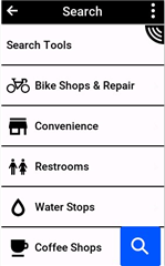
In many tests I read that one of the new features of 1040 is its POI database and searching functions that are now extended to find easily water stops. I can't figure out where this function is. Or did I misunderstood something?
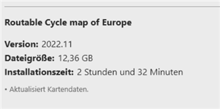
  • I hope they mean November 2022

    haha, that would be nice :)

  • and with water stops or not?

  • I found a solution for me.

    What is working with this solution:

    • You see the water stations on the map. If you provide a custom bmp picture, you can clearly distinguish them as water stops from other POI
    • I think (don't have the Edge with me) you will also see these POI near you in the list of close-by POI
    • You can set them as a navigation target by selecting on the map

    What is not working with this solution:

    • You will not find these POI in the POI list with their own category
    • While it is possible to find them by the custom search, the problem is that they don't have unique naming. Some of them are just called "node", other "node28474" with different numbers and some have the name of the fountain. If it would be possible to mass-edit all <name> tags in the GPX file so that they all have the same name like "water stop", then it would also be possible to search for them. I did not manage to do that.

    How to do it? Simple, as it worked before with the POI Loader.

    I downloaded a gpx file in OSM overpass turbo and exported all "drinking_water" (also "toilets") amenities of Switzerland into two GPX files. Then I downloaded two bitmap pictures signaling water and toilet and loaded all of this with the POI Loader to the Edge.

    If you are interested in a detailed instruction, I can add some screenshots.

  • Hi Baselpower

    I use the OpenTopoMap from https://openmtbmap.org/de/ 
    In this map the Water Stops are includen (without search)

  • Hi Baselpower,

    yes please. 

    I am very much interested in your workaround.

    with edge 1030 I exported waterpoint gpx files to excel renaming to whatever it had to be and exported to .gpi file to be dropped in Garmin/POI map.

    that worked fine.

    Now with Edge 1040 nothing seems to work so would be happy to try your workaround...

    Thanks in advance.

    Kind regards,

    Ronald

  • Garmin released the new CycleMap for Europe...unbelievable!
    But meanwhile I use the OpenMTBMap anyway...

  • And do they have water points? heheh