This discussion has been locked.
You can no longer post new replies to this discussion. If you have a question you can start a new discussion

Bug: MTB Navigation does not use roads to get to the trailhead. Just a straight line through everything.

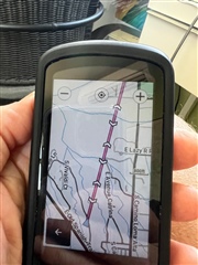
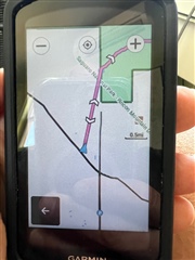
I doubt that this is how it is supposed to work.  I used MTB Navigation to to automatically create route in a trail system nearby.  I used Current Location (home) as the starting point.  I expected it to create routes that used the roads to get to a trailhead and then use the trails since there are no trails that start at my house.  What happened was that it drew a straight line path from my house to the trail head and then on the trails.  However the straight line to the trail head went through houses, roads, etc... Straight through whatever was in the way.  If, instead, I choose the starting point as a trail head then everything works fine.  I live within a couple of miles from several trail networks.  What I would like it to do is navigate to the trail head on the roads (like I do in real life) and then create a ride on the trails, and then take the roads back to home.

  • Would be able to take some screen shots of the issue and share those. You can post them on private message if you don't want them on the public forum.

  • Unfortunately, I don't know how to record screenshots and I can't find it in the manual so I took photos with my phone.  Here is a zoomed in image of the start of the route from a few blocks from my house.  You can see that is goes in a straight line through other roads and subdivisions:

    Here is a zoomed out version:

    It does this on every route that I look at unless I start right at a trailhead.  While creating these photos I found a number of other things that don't work.  A reminder of the sequence of events: when you enter MTB Navigation the 1040 shows you a list of the local trail networks.  Here in Tucson there are a lot of them.  Next I pick a network near me.  I find the following:

    1) It asks to use either Current Location or the map to pick a starting place.  If I choose Map I can add a pin.  However, when I go to create the routes is still says Current Location.

    2) The unit usually creates the first two routes almost instantly and then route 3 takes a while. like 10 or 15 seconds

    3) I then look at the routes.  When I click on one in the list of three it takes about 5-10 seconds before anything happens.  Then the route shows.

    4) If I hit the back arrow to get back to list and select a different route nothing happens for, again, 10 or more seconds.

    5) If I back up to the main Navigation menu and go back into MTB Navigation it doesn't ask me to chose my trail network again.  Nothing happens.  At this point everything seems dead and I am stuck in the  Navigation menu and nothing (selecting anything) works for about 30 seconds and then things start working again.  After it starts working again regular menu browsing works again.  But if I select MTB Navigation again after this it doesn't restart the process.  It freezes for about 30 seconds and then goes back to the previous route list  that I was looking at.  Everything is super slow.

    6) Also, I noticed that no matter which trail network I choose with the starting location at my house it always routes to the closest network and not the one I chose.

    Probably the most annoying thing about the whole process it that, after the initial route creation, everything is really slow and I always wonder if the device froze or if it just thinking.

  • Thanks.

    For your information the ability to take screenshots can be configured under

    System -> Display 

  • I see a toggle to turn screenshots on and off. No idea how you actually take them. Any tips?

  • Once you turn it on it should give you a pop-up message on how to use it.

    When it is on a press of the power button will take an image of the screen and write it into the Garmin\Screenshots folder as a  bitmap.