This discussion has been locked.
You can no longer post new replies to this discussion. If you have a question you can start a new discussion

Course points and navigation points both on a screen

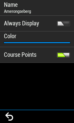
With SW version 9.0 (I'm not sure if previous versions had this too) it is possible to activate a screen with Course points combined with the navigation. This can be activated with an option in the Settings option of the Course menu for a specific course. (Load the saved course and select the Settings option)

When creating a course with Garmin Connect, you can add a Course point (like Water or other POI). After transferring this course it becomes a saved course on my Edge 1030.

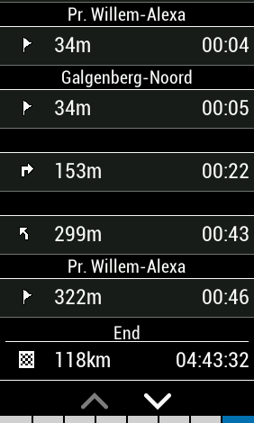
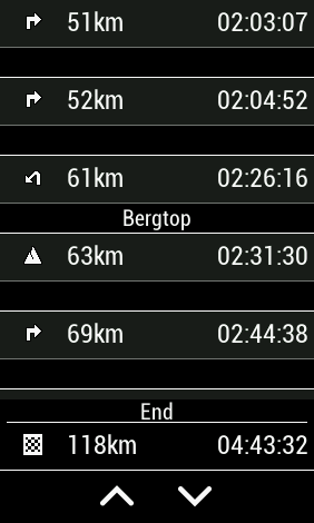
If you activate the Course Points option in the Saved Course on the Edge it does not show only the added Course point but also the navigation points (as being Cours points). You get a very long list of Course points. I was used to see only the created course points and the distance to them. Now I have to scroll through all the course/navigation points before I see the added course point.

I like the option to activate the Course Points screen, but I want the option to see only added course points and not the navigation points.

Is there a way to see only my added course points?

  • "Is there a way to see only my added course points?"

    No, there is not (not in Garmin Connect).

    You could use another route planner. You can do this in Ride with GPS (RWGPS) but the option of adding custom cuesheet items (course point) is a paid-subscription feature (it used to be part of the free membership).

    To do it in RWGPS, you'd delete the course points it adds and add/keep your own. Then, you'd export the route course as a FIT or TCX file.

    Another course planner (maybe, plotaroute) might let you do this too.

  • Thnx. The use of Plot-a-route works indeed if you export the route as TCX file. Have not tried FIT yet.

    It used to work with GC too (this summer I used GC many times in that way), but that seems to have changed with the latest versions. Don't know if it is due to changes in the Edge FW or in the GC.

    Using plot-a-route for now, I guess.

  • TCX is fine (FIT doesn't give you anything more).

    GC does (or did) not include course points for turns in fits sent to devices that didn't do routing (the devices that can do routing can also use course points).

    If you want to do interesting things with course points, I don't think GC is the best option.

    RWGPS is a good option but you need a paid subscription now. 

  • I agree that for that screen having the turns is not most useful, it should be a separate screen or have a filter option. 

    I use the Distance to Next and Course Point Distance data fields and those also were changed and are not most convenient now. One should show only the user points but both include the turn directions.

  • Garmin should put two options in the settings, one to enable User Created Course Points, and the other to enable Turn Direction Course Points.

  • I might write a program that lets people do this. Might be a few weeks...

  • another workaround if you prefer GC for planning a route (though planaroute is fine if 2500 points/route is not a problem): export fit from GC, convert it to tcx in some 3rd party tool (like https://www.alltrails.com/converter/) and copy tcx to Edge via USB. Surprisingly enough, only your custom course points will show up.

  • Have you tried exporting the TCX directly from GC ?

  • I don't think there's such option, gpx or fit only. gpx file contains no coursepoints, so it's useless.

  • ...excepr all fit->tcx convertors known to me set all course points types to 

    <PointType>Generic</PointType>

    so all summits/valleys/food/... icons change to generic flag Disappointed

    @Garmin-Matthew - please, give me back my course points! Getting an alert for every single turn completely hides my carefully selected key points ...