This discussion has been locked.
You can no longer post new replies to this discussion. If you have a question you can start a new discussion

Non-existent U-turns...

I plan my routes on RideWithGPS (using Safari and Chrome on a MacBook Pro) and then export the route as a KML file and a FIT file. I load the KML file into Google Earth to make sure that the route is okay. I then load the FIT file into my Garmin Edge 1030 Plus (which has the latest 6.40 software).

During the ride, my Garmin Edge will occasionally tell me that a U-turn is coming up, even though there are no U-turns anywhere in that route. When I reach the point where the U-turn is supposed to be, the Garmin Edge tells me to just continue. A few kilometres later, it does it again.

When I get home, I double-check the route on RideWithGPS and the Google Earth for the exact points where the Garmin Edge was telling me to make a U-turn and neither application shows a U-turn anywhere.

Does anyone know why the Garmin Edge does this?

Top Replies

All Replies

  • I always turn off recalculation on my Garmin devices to stop this problem happening.

  • I spoke too soon. I had disabled both Route Recalculation and Course Recalculation, and went for a 105km ride today. Near the 75km mark, the Garmin Edge inexplicably told me that a U-turn was coming up in 20km (i.e. near the 95km mark). For the next 20km, the Garmin Edge did nothing but remind me that a U-turn was coming up. Sure enough, when I reached near the 95km mark, the Garmin Edge told me to to just go straight. There never was a U-turn.

    When I got home after the ride, I double-checked the RideWithGPS route and the Google Earth KML file; there was no U-turn near the 95km mark. In fact, there were no U-turns anywhere.

    So, this time I decided to get some data. In the Google Drive below you will find the FIT file, the GPX Track file, the TCX Course file, and the KML file for the route that I uploaded into my Garmin Edge before the ride.

        U-turn Route Files

    When the Garmin Edge told me that the U-turn was coming up in 10m, I stopped the bike after 10m and took down the exact GPS coordinates using my iPhone:

            45°29'21.4"N 76°26'16.7"W (45.489270, -76.437967)


    You will see that there is no U-turn at those coordinates.  Any help in understanding this problem would be appreciated.

  • I have occasionally seen such behaviour on my 830.  I have no idea why sometimes it does it on roads with no turns.

  • You will see that there is no U-turn at those coordinates.  Any help in understanding this problem would be appreciated.

    You aren't designing the route using Openstreetmap (OSM). The Garmin has OSM maps installed.

    As far as the Garmin can tell, you are riding off the road and it doesn't know whether you should be on the path or the road.

    It's things like this that making keeping an eye on the map valuable. It's easy enough to see that there's no turn there.

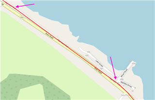
    The following is your route superimposed on OSM maps (in  RWGPS).

  • I have occasionally seen such behaviour on my 830.  I have no idea why sometimes it does it on roads with no turns.

    There are often things that explain it if one looks closely at the route. You haven't provided anything to look at.

  • Help me understand, dpawlyk.  I plan the route using RideWithGPS (I have a Premium membership) and export the FIT file and the KML file when I'm done.  I then plug in the Garmin Edge via USB cable to my Mac, and copy the FIT file into the NewFiles folder on the Garmin Edge.  I then load the KML file into Google Earth and check every road and intersection for potential problems.

    What should I be doing differently to avoid these U-turns?  And what do you mean by "keeping an eye on the map"?

  • You want to pick Openstreetmap (OSM) in RWGPS to layout the route. There is a map drop down on the upper right. The cycle map option is fine to use (it’s also OSM).

    Look at the image I posted earlier: your track doesn’t follow the roads on OSM very well at all.

    The “turn guidance” (the big white arrows) is a second route created/calculated on the device by walking your uploaded track and picking the nearest road/path that is on the map installed on the device.

    That process works better if you use the same map to plan the route as what is installed on the device. The device usually handles minor map differences but you’ll get better results by using the same map  

    I keep the map screen visible and I look at it. 

    If you looked at the map, it would have been clear there wasn’t any u-turn. 

    (You want to see the devices as giving you advice. Not commands you are required to follow.)

  • Which map do you use on RWGPS when planning routes (the dropdown box at the top right of the map screen allow you to choose which map) - I think it defaults to using RWGPS. I use the OSM Cycle map when planning routes on RWGPS, and I also use OSM maps on my Garmin 1030+, and I don't have the problems you are describing.

  • He’s not using OSM. See the image in my earlier post. 

    RWGPS is Google map (by the way).

  • dpawlyk will set you right on the planning. I can't see that your process of using the KML format and Google Earth adds any value assuming you are using the OSM overlay for planning the route and are sufficiently zoomed in while creating the route to avoid clicking in an intersection or inadvertently on a side street / path