This discussion has been locked.
You can no longer post new replies to this discussion. If you have a question you can start a new discussion

Non-existent U-turns...

I plan my routes on RideWithGPS (using Safari and Chrome on a MacBook Pro) and then export the route as a KML file and a FIT file. I load the KML file into Google Earth to make sure that the route is okay. I then load the FIT file into my Garmin Edge 1030 Plus (which has the latest 6.40 software).

During the ride, my Garmin Edge will occasionally tell me that a U-turn is coming up, even though there are no U-turns anywhere in that route. When I reach the point where the U-turn is supposed to be, the Garmin Edge tells me to just continue. A few kilometres later, it does it again.

When I get home, I double-check the route on RideWithGPS and the Google Earth for the exact points where the Garmin Edge was telling me to make a U-turn and neither application shows a U-turn anywhere.

Does anyone know why the Garmin Edge does this?

Top Replies

All Replies

  • Does anyone know why the Garmin Edge does this?

    Probably because the map the Edge uses is different from the one you use to plan.
    It is an old practice to use the same map for planning than for navigating.

    But I would say, if you are used to your planning tool, and the only problem is that you sometimes get U turns announced, which are then anyway not relevant: live with it!

  • Howdy

    This is Chad from Ride with GPS, and I see that you are export a KML file, and then exporting a FIT file from that. It sounds like you are using the KML file on Google Earth to review your routes. While I can't say what happens on Google Earth when KML is changed to FIT, I can tell you that we have a Garmin Courses integration that will get the route from your Ride with GPS account to your Garmin unit.  Check out the set information here - https://ridewithgps.com/help/garmin-courses. This will transfer the route from RWGPS to your Garmin account, where the route will be rebuilt by Garmin for your specific unit. 

    As a side note, we also offer a route cue review tool if you wanted to stay in RWGPS, rather than going to Google Earth to review.  https://ridewithgps.com/help/cue-review-tool 

    We also have support folks available 7 days a week, so email us at [email protected] with any other questions.  

    Enjoy the ride!

  • Post a link to the route page.

    And indicate where it happened (at least one place).

    There are a few reasons you can get U-turns. 

  • route will be rebuilt by Garmin for your specific unit

    While the link between RWGPS>Garmin Connect>1030>GC>RWGPS can be useful unfortunately as the course passes through GC on the way to the 1030 all the Cuesheet /Course point entries are stripped out, ok if you use the 1030s "turn guidance " but not if you don't but perfer the course points for navigation. On RWGPS, even in the absence of the review tool (premium feature), just clicking on the cue entries in sequence is useful for "checking" the route.

    Chad, your professional expertise could be useful here too, the ability to set a user entered notional average speed rather than a "random" one would be really useful. Reviewing a selection of courses downloaded from RWGPS onto the Garmin shows average speeds from 1 through to 20 kph

    forums.garmin.com/.../what-is-default-speed-for-virtual-partner-on-route-generated-from-rwgps

  • Yes, I've been living with it for almost two years now.  The problem is that when the Garmin Edge notifies me about the U-turns, it neglects its other duties, such as indicating when the next turn is and what the name of the upcoming road is.

  • Yes, I've been living with it for almost two years now.

    What you can try (if it is worth the effort…)

    Use the free Garmin program Basecamp for a test course.
    Plug in your Edge to your PC/Mac and start Basecamp.
    You now can (after waiting until loaded) use the exact map of your Edge for creating the course.
    Save it as GPX to your Computer and copy it then to the Newfiles folder of your Edge.
    Test the course if this would eliminate your problems.

    (at least - this is what I would do. But, ok, I‘m familiar to Basecamp… Wink )

  • Why?

    If he's already using OSM maps to plan the route, why do you think the BaseCamp ours will be different?

  • I have another explanation for the unforeseen U turns:
    I can only speak for Basecamp here, but perhaps other planning tools behave similarly.
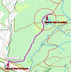
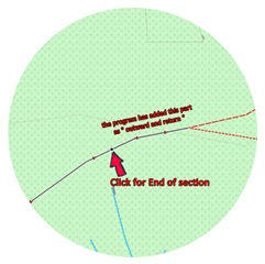
    When planning a course, it can happen with Basecamp that the route to the next click is unintentionally (and often unnoticed) extended by a short distance. This usually happens when you click just before a crossroads.
    If you then continue planning, you have implemented a short section of the route " out and back".


  • RWGPS doesn't create those out-and-backs.

    But there can be routing glitches if you click on (or very near) intersections.

    The problem is that the cross street can be selected, which means you get a spurious turn if the  map in the Garmin isn't exactly the same.

    Avoiding this problem is easy by just not clicking near intersections.

    W really need to see span example. It's possible the OP is doing something that makes it happen.

  • Thank you all for your responses. I think I may have figured out the problem, and it is related to this:

    forums.garmin.com/.../navigation-keeps-indicating-u-turn

    Basically, I lead no-drop group rides and I occasionally turn around to check on the riders that fell off the back.  When I do that, the Garmin Edge tells me that I'm off-course (which is fine) but, unbeknownst to me, the Garmin then re-calculates a new route that is not the same as my pre-planned route. That's when it starts peppering me with U-turns.

    As the users in the other thread have mentioned, this is an undesirable feature. I see why this feature would be useful in a car-GPS (in fact, my Garmin Nuvi car-GPS does exactly that) but in a bike-GPS where a pre-planned route has been loaded, the bike-GPS should recalculate the route to return to the pre-planned route, not to the destination (which could be behind us if we're doing a loop).