This discussion has been locked.
You can no longer post new replies to this discussion. If you have a question you can start a new discussion

How to define the right type of guidance during road navigation.

Hello,

I only use my 1030 + for the road and I have correctly configured my profile like this.

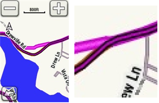
Sometimes when I follow a programmed track and the main road turns left and the track follows it, the system says to turn left because there is a small unpaved path in front of me.

Why ?  I stay on the main road and don't want to take an unpaved path with a road bike.

In another case, with the main road turning right and the programmed track which takes another small tarred road straight ahead, there is no warning to change lanes.

If you do not have the active map, you continue on the main road !

How do you configure the 1030 + to give only the right changes of direction?

Thanks for your answers.

  • If you are following a route, programmed on something like RideWithGPS, that is where the problem lies. If you want to stick to roads, on RideWithGPS, use the "Driving" option to ensure that the route sticks to real roads.  And when you plan a route with RideWithGPS, use the little man to show the Google StreetView.  When lines are BLUE, it means that the Google car mapped the area. If a road is not blue, then the Google car did not pass there and most likely it is an unpaved road.

  • Thank for your answer, but it's not this problem because I always use "Driving" option when I make my routes.

    The problem is the 1030 + informs me of a change of direction when it is not necessary as below.

  • I don‘t see the problem. Ok, the command is not necessary, but where‘s the problem?

    This kind of „not necessary commands“ happens with car navigation, too.

  • Desde hace diez años llevo un Garmin Edge en el manillar de mi bicicleta de carretera. Primero un 800, luego un 1000, un 1030 y ahora un 1030+.

    Mi experiencia es que la navegación a un punto cualquiera es un desastre. Rutas que se pueden solucionar con 20 km de recorrido, Garmin las puede plantear con itinerarios 3 ó 4 veces más largos. Utilizando carreteras sin sentido, caninos que no deseo, etc.

    Cuando quiero seguir una ruta, primero la diseño en Strava y después la envío a Garmin. Es la única manera de poder navegar. Como señale en mi Edge un punto de destino y le deje elegir la ruta, preparémonos para recibir la respuesta más estúpida.

  • Agree, but this doesn't help with the 2nd example in the OP where the track continues straight ahead, but the main road continues at an angle, and there is no navigation prompt at all (meaning it is likely that one would miss a 'turn' off the main road and end up somewhere different than planned)

  • How do you configure the 1030 + to give only the right changes of direction?

    The simple answer is that "there is no such configuration" (unfortunately).

    You are talking about three separate problems: (1) one picking the wrong road/path ("ways"), (2) not showing turns (they aren't related), not announcing staight-aways (when the main road turns).

    ===========================

    Keep in mind that the point of using (following) a track is to pick exactly what roads/paths you want to use.

    If the unit used  "avoidances" (configurations like "road cycling") when following a track, the unit would often end-up using ways you didn't choose and don't want..

    Thus, when you are using a track, the unit does not use the "avoidances" at all (you really don't want it to use "avoidances!)

    ===========================

    Note: you can also get the wrong roads/paths selected if the map used to plan the route is different than the map installed on the device (the devices come with maps based on Openstreetmap (OSM) data.

    You want to use the same maps when planning routes that the device is using. That is, you should use the OSM option in RWGPS (you can change the map using the dropdown at the upper right of the map window). Different maps often place roads/paths in slightly different locations. When calculating routes, the Garmin picks the way that is closest to the track.

    The mode ("driving", for example) you use in RWGPS doesn't matter as long as the track ends-up following the ways you want to use. That is, the Garmin has no idea what mode you used to create the track.

    ===========================

    The first problem (the unit picking the wrong road/path) is what I call the "short cut" problem. It's an old problem. I believe it's a consequence of the unit trying to make the route calculation faster. Sometimes, the unit chooses a path that is a short-cut. (We are assuming your track is actually following the road/path you want to use.)

    There is really nothing you can do to keep the unit from doing this.

    ===========================

    I don't know why the second problem (not showing turns) occurs. With the example you showed, it might be that the path to the right is a bit after the turn.

    The third problem likely occurs because there's no turn.

    ===========================

    Using the map is a very important tool for navigation. With a bit of practice, one often knows about turns before they are announced (or not!). One can also often see the deviations (the shortcuts), which are not too hard to ignore. The map provides a backup when other navigation features don't work or are confusing.

    If a reason you don't use the map is because you want to see more data, you might want to check out the following datafield.

    apps.garmin.com/.../8633c044-afff-4834-b71f-9f10113b5276

    ===========================

    Using course points might also help you.

    Course points are icons embedded in the file (FIT or TCX) representing the location of turns (and other things). If you have course points enabled, the unit will show a pop-up (and a beep) when you get close to the position of the course point. These are separate from "turn guidance".

    One issue with course points is that they don't get displayed a head of the turn (or whatever). RWGPS has an option to move them earlier in the track but it's a paid feature.