This discussion has been locked.
You can no longer post new replies to this discussion. If you have a question you can start a new discussion

Question on trail forks map function

Hello.  Before I commit,  I am trying to understand basic trail forks map function.     On my older 1000 I have purchased ( by donation ) the trail forks img.    With other maps off I see all trails, trail names etc as I track through and explore trails.   
Is it the same on the embedded trail forks maps ?    I see talk of “trail routes” and forksight and pop ups Etc.   What I hope is that I can simple see live map which includes all of the relevant trail maps and names.     I am worried that the embedded feature might be actually worse than my simple img.   
Assuming the maps are just ....visible  .... can the features like forksight or other pop ups be disabled?    Also I should ask if the trail forks overlay is always on or is selected in maps.     
I’m Just finding very little clear samples of maps and basic use in reviews.   Lots of words on the “cool” features.   But not what I want.    Thanks.    

  • My experience with trail forks:
    (meanwhile I have disabled the whole thing because all trails are on my OpenMTBmap anyway...)

    There are 2 things to consider:

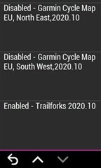
    -Profile - Navigation - Maps - Mapinfo.
    you can enable or disable Trail fork map.
    enabled: all trails are overlayed to your „normal“ map in green color
    disabled: no trailfork trails visible

    -Profile - MTB/CX - Forksight
    enabled: if trailfork map is enabled a screen pops up if a trail was detected. It shows the track and some infos
    disabled: no screen pops up.

  • I've got trailforks running on my 1030 plus.  Its ... okay.  If I understand the question correctly, you're wondering if you can turn off all other maps and just leave the trailforks map on and see the trails that its got.  Yes, you can...

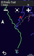
    .Only trailforks maps enabled here

    Here's a sample of trailforks maps only near me...

    Nearby trailforks trails with only trailforks maps on

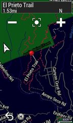
    Lastly, I turned all the normal maps back on but left trailforks off and the same general area looks like this...

    Local trails with only garmin maps enabled

    The trail I am highlighting is very popular so I'm not surprised it shows up on the base garmin maps too.


    Did I answer the question?

  • Thank you both!  That is helpful.  Seems to be quite normal and as I’d hoped.    

    rob. 

  • Sorry to add another one.  .but your pics were great.    If I leave maps on, as well as Trailforks, do I get both?   Or does cycle map override (as it does on my  1000 with manually added img?         I suspect it may be too cluttered.   

    And I should ask why you noted it's only "ok" ... interested to hear your perspective.    

    Thanks again.  

  • It does seem to overlay everything.   I said its "ok" because it's a bit clunky.  When I go to the trailforks IQ app i have 3 options:  "My Routes", "Nearby Routes", "Browse Top Routes".  


    If I look at my routes, I see a list of the routes I created.  If I click on one, I see a squiggly line (the route) on a blank screen.  There is no way to tell where this trail is in relation to any street or anything else.  If I hit the 'download' button and launch with a profile (mountain biking) then I can see a map.  Just a minor annoyance.  The routes are all listed in alpha order so if you had a route called "Awesome ride" and it was on the moon, it will be at the top of your list all the time.  I wish it would sort by distance.  

    When I hit "nearby routes" it takes a moment to get my GPS location then list all the stuff it can find.  This list does seem to be "somewhat" based on distance from me but I always have 1 trail at the top of the list that is several more miles away than any others.  Also, I seem to have maybe 15 trails with the same name "4 Trail Brown Mountain Ad" (it gets cut off but that's okay).  I'm not sure what is happening here.  On the trailforks website , "Brown Mountain" is very close to me and its a well know area to ride with several trails but I'm not sure why its showing so many.  I THINK its actually pulling up routes other riders have created but I need to explore this more.  Also, if I click one of these to see it, I get the same trail line on a blank page as above and have to download before I can see this against other map data so I can figure out where its at. What annoys me most is if I want to go back to the list of trails, the back button takes me back to the 3 menu options mentioned above and I have to hit "Nearby Routes" and wait for GPS to figure out where I am again.  I wish it would just go back to the list it already generated.  That one is annoying.  So, trailforks certainly needs some programmer love.

  • OK.  Interesting.    But the IQ app aside . . .does the map seem to show all trails and trail names on the map as well?   On my Trailforks img, I like to see the web of trails and I free ride though them.   Names appear as well.    Sorry to be repetitive. . . I just want to be sure I understand.    I don't use the iq app. I find most segments too short and easier to simply browse the map.        On closer look at your Trailforks sample I don't see names on the trails.   (on your normal cycling map sample I do).   Is that merely a zooming issue?  

  • Yes, the trails and trail names are showing on the map.  I'm in Pasadena, CA and just to be sure, I scrolled the map down to Eastern San Diego, CA to randomly find something there that I know nothing about.  When I zoom in, the trailforks trails are in a darker color and stand out against all other roads.  When I zoom in enough, the trail name shows up.

    If you like, I could screenshot an area near you that includes a trail you may already be familiar with.

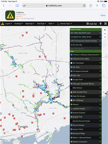
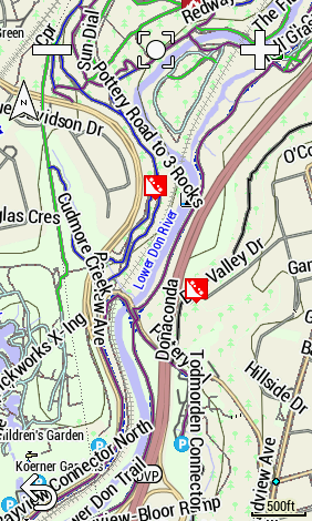
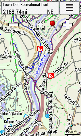
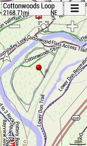
  • That’s super helpful.   I’m feeling confident now.    I don’t want to create work for you but i’ll add a quick screenshot of an erea in Toronto that could be a good test.   Just NE of the word Toronto are some trails I know well.    Only if it’s very easy    You’ve really already gone above and beyond the call!    This is a great resource !  

    word Toront

  • That is fantastic.   Perfect.   It’s all there and you’ve already shown me that I can de-clutter if I want to see solely the trails by turning off cycling / baseman.    I really appreciate it.  Amazing.   That’s very much!!