Wrong zoom

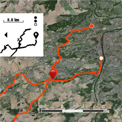
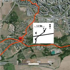
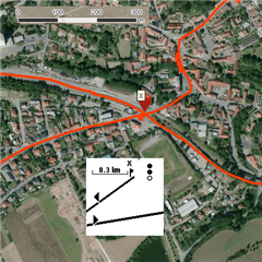
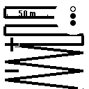
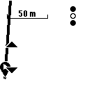
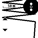
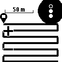
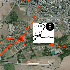
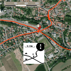
I found that when I use Zoom - (for instance Navigate-Activities-(loading)-Map-Zoom ) the map is very coarse. It looks like Instinct use the same small amount of saved coordinates for all levels of zoom. This makes the zoom useless.

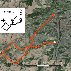
See images - I chose the place where my course crosses and where I saved location. While the map shows my activity file perfectly, the same place on the watch display is hardly usable.

Is this bug, or unpleasant feature, or wrong setting of my watch?

  • I think it's in the 'unpleasant feature' category Slight smile I'm using courses (both from Garmin as well as imported from GPX files from Locus) a lot and unless you are planning a very short and rather simple route, they're pretty limited. Main issue (I think) lies in limiting number of GPS points that build up the course - on long routes, like >=100km bike ride this makes the plotted path very imprecise sometimes - if during import watch removes a point that was part of, say long left turn you end up with a 'chopped' turn - instinct is showing to go directly through a building rather than follow road etc. For short routes (less than 20km) it's hard to observe this issue. So - if you really need a super precise guidance I'd rather go for Fenix (it has a full fledged map, so it will be easier to navigate) or Edge (if you're a biker) - it's navigation experience is super smooth when your pumpig watts on a road bike or mountain bike :)))

  • Yes, that is a feature Frowning2.
    I have found that Instinct does not display perfectly any .fit file, which contains more than 200 points.
    When I generated "ladder" course containing 200 points, Instinct can draw it perfectly.

    With 201 points it starts to make shortcuts.


    It seems that beginning is more distorted than the end. Ladder with 600 points has straight section, later zigzag section, and only the end is plotted as original ladder.


    So when I crossed my own track later, the original track was displayed out of its real position.
     When I shortened the activity file to about 960 points (from original 5479) , the result is much better. But only if I shortened it to 200 points, I could use maximal zoom and I could see all recorded points.


    The same feature makes my problems with navigation, which I asked about earlier.
    forums.garmin.com/.../wrong-display-during-navigation

    A course on the Instinct's display is distorted, and that's why it looks like I am Off Course,
    while I am exactly on course and GPS see my position right.

  • Thanks for showcasing this. Yeah, I was disappointed too. I did not expect full fledged turn-by-turn navigation, but limiting course to 200 points severly impacts this feature Disappointed

  • Thinking about it, I would say that this approach is more or less necessary. To display the part of the course, the algorithm has to check each of points, if it lies in the area shown on the watch display. When there are thousands of points, it is impossible to do it in real time.

    So I suppose that the course is simplified to 200 points by some algorithm like en.wikipedia.org/.../Ramer–Douglas–Peucker_algorithm .

     I have found that when I need a really detailed navigation over a long course - typically about 80 km on the bike - I can divide the whole course into shorter parts and when one ends, I start next.

  • Yeah, I agree they must have done it due to hardware limitations and budget constraints - I suppose you could do a workaround to just load nearest 200 points and unload parts of course sacrificing zoom out functionality (or making zooming out painstainkingly slow). Anyways your idea with splitting the course into several is really good - I'll definitely experiment with this Slight smile

    BTW. I take back my complain about turn-by-turn navigation. I was uploading courses via abominable Garmin Explore and it turns out Explore does not include some metadata for the turn-by-turn navigation to work. When I upload via Garmin Connect courses the turn-by-turn navigation is really nice - several notifications about approaching turn, with meter countdown, works awesome Slight smile

    PS. Tip - just discovered it recently. You can have one field of your choice on map screen! All you need to do is customize given Activity profile to include map screen by default. Then you can edit that screen to include one field and choose the field.