Problem with distance and pace measurements on Instict

Hi,

I have a running route which is exactly 4.0 miles. However the Instict records about 3.7 miles. This means my pace is down on what it should be too. I've updated the Instinct to the latest firmware and tried GPS+GLOASS. Any ideas?
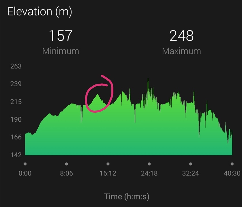
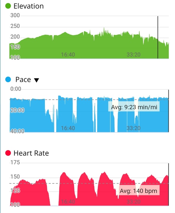
Top Replies

All Replies

  • I haven’t had to correct the altimeter data as it has been pretty accurate

    Depends what you understand under "accurate". If you mean without dents, and without spikes, or if you mean the total elevation gain, then yes. But from the profiles you posted, it is clear the altimeter was off some 30 meters (or feet?). Maybe it was only in that case, but calibrating it, or using the auto-calibration, would make it match the topographic data (and the reality) better. 

  • All the issues I had with the Barometric Altimeter elevation recording and readings have been fixed by wearing the watch on my right wrist during running and hiking. 

    The heart rate monitor locks on and tracks my activity much better now its on my thicker and dominant wrist as expected. 

    Over clothes if I am wearing long sleeves. No more spikes or drop-outs.

    I am more than happy with my Instincts performance on the activity heart-rate, GPS Accuracy, and elevation recording.

    It's the only trail running and hiking watch I can wear throughout the day and not worry about it getting damaged. 

  • No more spikes or drop-outs.

    You are certainly perfectly right in most of your arguments, I just have to note that the spikes shown in the earlier post are actually unrelated to the issues you list. They only appear if you use the function "Elevation Correction", and did not calibrate the altimeter. Whether you wear the watch left or right, or whether you sweat or not, or whether you cover the watch or not, or whether you protect the sensor orifice or not, won't matter. The only thing that matters is having the altimeter properly calibrated when using the Elevation Correction feature.

  • I religiously calibrate the altimeter, especially ensuring it is correct before a workout. 

    I've only used the elevation correction once and that smoothed the spikes, it didn't cause them. 

    Thanks for sharing your knowledge and advice, I'm all for being educated in these matters. 

  • This is from today's workout doing hill repeats as part of the Garmin Coach Training. 

    The altimeter was calibrated by DEM before I set off. 

    The first mile warm up the a rest and getting to start of hill  running up, back down, then rest and repeat 4 times.

    Heart rate shows a better view than the elevation readings. The altimeter nailed the first hill repeat, then had drop outs on the rest. 

    There should be 4 that look like the first one circled. 

  • I did manage to rack. Up some floors though. 

  • I've only used the elevation correction once and that smoothed the spikes, it didn't cause them. 

    We speak about two completely different issues. The spikes I am speaking about, are shown in the post of 3854086 earlier in this thread. They appear only in profiles with the Elevation Correction enabled, and only if the altimeter was not correctly calibrated. 

    Your case is completely different - your altimeter seems to be recording irregularities already alone, most likely due to the sensor orifice being blocked by something, filled with sweat, or opositely being exposed to suddent pressure changes (wind). Keeping it clean and protecting it against sweat, and gusts of wind should help. Taping is a possibility, though a tape that is not permeable or flexible enough to allow the pressure transfer, is not the best idea either. Something eleastic or permeable would be better.

  • One quick question trux. Can you use the Instinct to measure altitude with typography only?

  • Thank you for your reply and information. 

    I am thinking it is due to wind, cold pockets of air, quick movement with rapid changes in pressure.

    My hike yesterday was perfect. 

    I'm thinking that expecting a barometric altimeter to actually record data at speed is more down to expecting things that are not what the instrument is actually for.

    Also, does it matter, as long as it's useful as an indication of altitude change, and not a constant recorder?

    I think maybe it's more my OCD lol

  • Can you use the Instinct to measure altitude with typography only?

    With typography certainly not - typography is the art of arranging letters and text, but of course I know it was just a typografic mistake, and that you meant topography (study of the shape and features of land surfaces). Slight smile

    So, using topography only, for showing elevation profiles, is possible by the earlier mentioned option "Elevation Correctios' in the activity details on Garmin Connect Web. If you meant showing elevation live on the watch, then you can do it at any moment by launching the DEM calibration (for the topographic elevation), or by long-pressing the GPS button (for the GPS acquired elevation). However, the values reported on the altimeter widget will continue coming from the barometric altimeter.