Instinct 2 with Edge 840 bike riding?

I have an Edge 840 that I use for road/gravel/mtb. I'm purchasing an Instinct 2 for walking. I see that the Instinct can broadcast HR to the Edge. It also has biking activities.

My question is, when biking, should I be use the instinct for more than an HR monitor? Should I be starting an activity on both devices?

Maybe so I can see recovery, sleep, morning stuff on the watch?

Just wondering how you use both devices.

  • during activity it checks DEM data so the barometer is not completely of. Garmin instinct takes DEM from phone and does not need any maps for that

  • I love people who use their opinions as facts.

    https://support.garmin.com/en-US/?faq=R4I5hFFcUk8gJPC4zi0Xv6

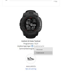
    You can't Enable this in Instinct 2 because it doesn't have maps.

    You can Enable this in Edge (and presumably all Garmin devices which come with topo) because it has maps. Enabling this aligns elevation with real world survey data, not with barometer which might be out by quite a lot - from multiple years of first hand experience on 2 different instincts.

  • i love when peaople think they are correct but they are not. your link jut proves you are wrong it says garmin connect web not on device. scroll down in your link and you will see a vivoactive 3. all garmin devices can do this. have nothing to do with maps on device. 
    my own activity 

  • Bullet is right, both the Edge 840 and Instinct 2 calibrate the barometric altimeter at the beginning of each activity (if Auto Calibration is enabled in altimeter settings) and use the barometric altimeter for recording the elevation profile. And both of them can optionally use DEM, GPS, or Manual elevation data for the calibration. Instinct 2 needs an active connection to a phone with Garmin Connect and Internet connection, unless the DEM data for the current location is already stored in the cache.

    In contrary, the Elevation Corrections (that we can see both at Edge 840 as well as at Instinct 2) are only available then, when the device does have a barometric altimeter (and in that case it was used for recording the elevation profile). So, exactly as Bullet wrote, the existence of the option in GC Web is the proof that the recorded profile came from the barometric altimeter, and not from GPS (at devices without altimeter) or from DEM.

  • Nope, sorry. One of the reasons I switched to the Instinct 2 was the changed barometer-hole which improved elevation data dramatically. You can switch to map-based elevation-data in Garmin Connect later and (for me, northern Norway) it was all over the place. With the Instinct 2 (and now Instinct 2x) it is way better.

  • You can switch to map-based elevation-data in Garmin Connect later and (for me, northern Norway) it was all over the place.

    If it was all over the place after you activated the Elevation Correction, then it means the barometric altimeter was not properly calibrated at the start of the activity, and that there were dropouts of GPS signal. Because when you enable the Elevation Corrections, the barometric elevation is replaced by the topographic elevation only at track points, where the FIT file contains GPS data of sufficient quality. When it is not the case, the Elevation Correction uses the barometric data for that specific track point anyway. And if the watch is not calibrated, it results in abrupt changes of elevation on the "corrected" graph.

    It was discussed already years ago for example here: (+) Elev Corrections Issue

  • Right, I had a chance to do a test run to clarify what actually is going on since I remember having discrepancies between Instinct and Edge in the past, and Edge was much closer to reality.

    My test run was based on:

    1. No phone (I never have a phone on me when cycling). Making an argument that device needs a phone to get correct readings during activity makes that device unusable.

    2. Edge 530 (using speed sensor, chest HR strap and power meter with cadence)

    3. Instinct 2x (using speed sensor, chest HR strap and power meter with cadence)

    4. Instinct 2 (using GPS, optical HR sensor and no power meter and no cadence)

    I realise that HR and PM/cadence shouldn't be relevant but am mentioning it for the sake of good order. 

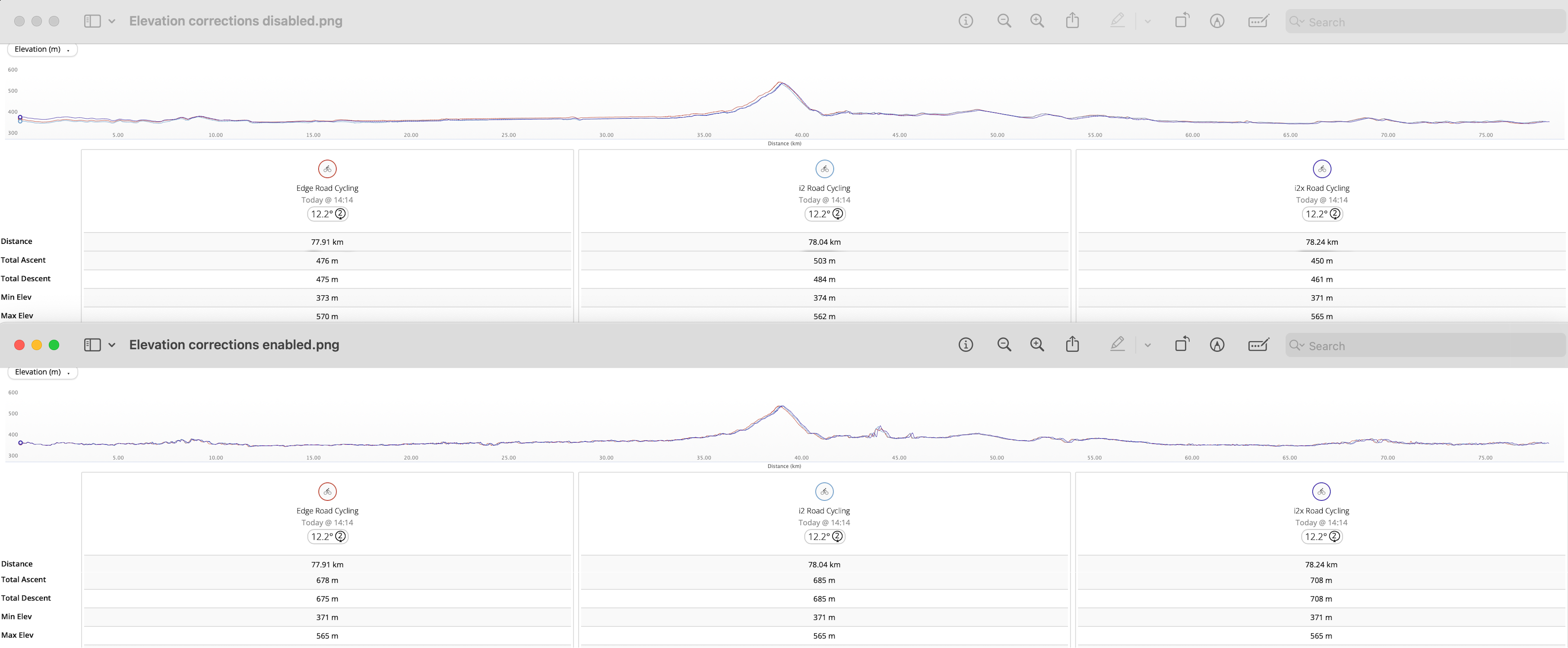
    Looking at barometric data (elevation corrections disabled) all 3 devices showed different total ascent and total descent. But they weren't miles apart (as I remembered from the past). And this data is close to real world data, based on trying to reproduce this route by hand in maps. Hence you'd argue that if device relied just on map data (using elevation corrections) this should reduce these differences to minimum. Well, it should but it doesn't. It actually made the data completely rubbish.

    When I went to enable the corrections, the measurements went completely haywire on all 3 devices. And looking at the graph all 3 devices showed the same, completely unjustified, variations. Especially exaggerated around 44- 45km mark where it experienced a complete meltdown - the barometric graph reflects reality pretty well. The whole "corrected" route looks like a jagged mess of sudden small drops and rises (same on all 3 devices) which added up to 200 metre variance vs elevation corrections disabled.   

    So to close off, I was wrong in general but I did remember right that the variations could be massive - that said now I understand that potentially the source for the variations I saw was the elevation corrections, which - to be frank - seem to produce nonsensical outputs, especially since they claim to be based on "professional survey data". 

    EDIT to add, based on trux's input the alleged elevation correction issues are a product of baro not properly calibrated and GPS signal dropouts. Sounds like BS to me, simply because all 3 devices used at the same time display these variances and I was riding on public roads covered by maps in an area with very good GPS signal. And that glitch at 44-45 makes literally 0 sense, if GPS was down and baro was used instead then the gap wouldn't be as pronounced. If what trux/Garmin are claiming is true then why not simply use the mapped route and average out the path based on it which would eliminate micro gaps (if these are tripping the reading).

  • 1. No phone (I never have a phone on me when cycling). Making an argument that device needs a phone to get correct readings during activity makes that device unusable.

    You can calibrate the device before starting, you do not have to have the phone with you. Either completely without the phone, to a known altitude, or in (or near) your home (on the ground level though) when still having your phone in the reach.

    Otherwise, frankly told, I do not quite understand why you are complaining, because after looking at your data, they look to be pretty accurate. The difference in the total ascent is within some ±5% at the total ascent, which is excellent, and within around ±2% at the Total Descent, which is absolutely fabulous! The biggest difference is between GI2 and GI2X, and there I suspect that you have perhaps worn them each on the opposite wrists, or perhaps one in the backpack, and they were not both exposed with the sensor port orifice in the same direction, which would, of course, have a significant influence on the sensor readings.

    As for the scattered curve after applying the Elevation Corrections, I do not think there is any problem with lacking GPS data, in your case. That looks completely differently in such situation. Your curves look fine, and the higher numbers are the result of the granularity of the topographic data. I'd rather rely on the barometric data, the elevation correction is really to be used only if there is no better alternative. And that's why the barometric profile is the default one.

  • You can calibrate the device before starting, you do not have to have the phone with you. Either completely without the phone, to a known altitude, or in (or near) your home (on the ground level though) when still having your phone in the reach.

    I never said anything about the phone, bullet brought this point in to back up his position. To me this point is 100% irrelevant as the watch and the Edge are sold as standalone devices. And they are equipped with sensors allowing them to establish correct position, except Instinct is missing maps hence it can't get the DEM unlike Edge.

    Otherwise, frankly told, I do not quite understand why you are complaining, because after looking at your data, they look to be pretty accurate.

    As I said, I was wrong in my initial judgment, based on erroneous data I saw before. I think I explained it already.

    The biggest difference is between GI2 and GI2X, and there I suspect that you have perhaps worn them each on the opposite wrists, or perhaps one in the backpack, and they were not both exposed with the sensor port orifice in the same direction, which would, of course, have a significant influence on the sensor readings.

    They were both on my wrist, shielded from wind. Obviously this is why Garmin is specifically stating that Elevation Corrections should help to eliminate any inconsistencies which could be introduced by either wind or pressure going up or down, as the data is supposed to be measured based on maps.

    Your curves look fine, and the higher numbers are the result of the granularity of the topographic data.

    These don't look fine. There's no way the quality of data can be as bad since if you use Garmin's own course planner the resulting totals are not aligned with totals coming from elevation corrections which should use the same mapping data as the course planner. Since I know which roads I was on and you don't I can assure you that these extremely even roads don't undulate like a BMX or a CX course like what can be seen on the graphs. 

    Not to mention the absolute spazz out event that happens between 44 and 45 km.

    The only time I or anyone else should accept this as "fine looking" would be if I was off road riding through an unmapped area.

  • I never said anything about the phone

    You explicitely wrote:

    1. No phone (I never have a phone on me when cycling). Making an argument that device needs a phone to get correct readings during activity makes that device unusable.

    As I explained, you do not need the phone. DEM calibration is being done only at the start, and as I wrote you can do it in advance, and riding without the phone. 

    Since I know which roads I was on and you don't I can assure you that these extremely even roads don't undulate like a BMX or a CX course like what can be seen on the graphs.

    Well, I cannot comment on it, since you did not provide any detailed data of the track, and of the course, but as I wrote, in your place I would simply use the default barometric profile. All three profiles you have shown are pretty much identical.