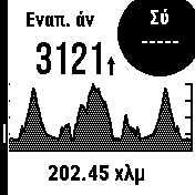
When you import a long route, the height diagram is a bit confusing because the x-axis doesn't show the distance and the y-axis doesn't show the height.
Also it would be very useful if the user could divide the route to desired segments, for example every 50km.
I have attached a picture of route i rode yesterday,202.45km and 3121m of ascent, and couldn't see the climbs because i couldn't read the chart easily.