User locations on map

On page 62 of the manual. It explains an option. Show or hide user locations on map. However nowhere does it explain how to get them to the watch. Google failed to help Worried

Garmin connect gpx files for transfer have the ability to have user points in the Courses section but they don't seem to transfer. Why would it let me create something on my route that doesn't seem to work?

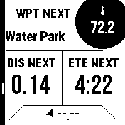
Anyone know how to do it? It intimates the point displays with it's text in various bits I've read.

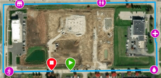
I had this with the original instinct. A little flag appeared on the map with the associated text. I used to use them for mountain peaks with their names and streams etc.

J

Top Replies

All Replies

  • Seems to be called course points in Garmin connect. You can add a name and a type eg generic, water, info etc.

  • user locations

    These are also called Saved Locations.  They are not the Course Points added to Courses in Garmin Connect.

    Long press your GPS button and you'll see an "Acquiring Satellites" banner.  Once GPS is acquired (go outside), you'll see your coordinates.  If you press the GPS button again, you'll have just saved your first location.  This location will now show up on your map if you are in the vicinity.

    You can also look into the Explore App (phone & web) to add more locations that can be sync'd to and from your watch.

  • Just using Explore. I see now. Strange that the connect app allows "points" that are essentially unused. Wonder what the idea is behind those? Seems a lost opportunity to keep it simple to me?

    A bit disappointed with the Explore option as although it syncs points, the associated text isn't displayed even though when you look at the point via the watch setting, the name is there.

  • Wonder what the idea is behind those?

    The available list of Course Points in Garmin Connect was expanded not too long ago, in my opinion, to support the UpAhead feature released with the f7 and recently ported to the 945 LTE.  UpAhead is a Data Screen that shows a list and distance to Course Points that are, well, up ahead on your course.  Even thought the I2 doesn't have the UpAhead feature, it can still take advantage of the Course Point feature in GC courses.  Below is a screenshot of one of my Hike data pages with some of the Navigation Data Fields that use the Course Points information.  But, as you've found out, not the same thing as Waypoints/Locations.

    the associated text isn't displayed

    I'm pretty sure that the waypoint/location name used to be displayed on the map, but that feature was removed a few SW versions ago.  Maybe before the I2 was released.  The screen would get a bit cluttered if there were multiple points shown.

  • That's really interesting. I find generally it way too convoluted to join up so well!

    On your picture, the way point next water park. How did you do that? Is it just a data field? What is it called? Built in our installed from iq store?

    EDIT: think I've found it, Navigation fields? I'll set up a route and try it now from home. I'd never have figured that out!

    Thanks

    J

  • On your picture, the way point next water park. How did you do that? Is it just a data field? What is it called? Built in our installed from iq store?

    EDIT: think I've found it, Navigation fields?

    I think you're getting there...

    Below is a simple course I created in Garmin Connect for testing.  You can see that I added Course Points along the way.  The first one (water drop) I called Water Park.  The subsequent course points all have names as well.

    I then setup one of the Navigation Data Screens to my preference as shown above.  All Data Fields I used are from the built-in field set.  There is a complete list in the Appendix of the user's guide.  You can also add CIQ Data Fields if you wish.

    Data Fields:

    1. Temperature
    2. Next Waypoint
    3. Distance to Next
    4. Time to Next
    5. Dist. Remaining

    So every time I use the navigation feature in any activity, this Data Screen is automatically added to my Data Screen loop.  You'll also get alerts as you approach and arrive at each of the locations.  All very cool stuff.

  • Yeah, just been walking round the local houses looking right dodgy going slow and looking at my watch!

    I've a bit more of a complication as I import routes with points from my library of routes in locus maps on Android and I'm getting names not appearing sometimes but I've got the gist of it. Works fine every time if I create all the data direct in connect.

    A bit more fiddling and I'll be be there.

    Thanks ever so much.

    J