using mkgmap to change zoom level details

Has anyone had any joy using mkgmap (or any other method) to change at what zoom level things appear on the Fenix 7 maps?

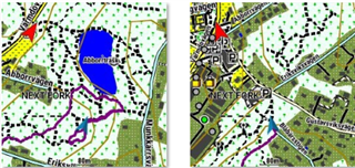
I have this persistent problem with huts and refuges not showing until I zoom right into the map, which makes it difficult to see them if I don't know exactly where they are.

(Toilets show up much sooner. Taking a crap has higher prority that sheltering from a storm?)

I've fiddled with the map details setting on the fenix but that didn't help.

Thanks!

NOTE: I have a blog about this at  Zoomies using mkgmap (terrycornall.wixsite.com) 

NOTE ALSO: I have found that some annoying contributions to OSM maps mark huts as an area but not as a point so this method of using mkgmap will not detect them. I will try to come up with a rule for areas that picks them up. Sigh. Consistency might be the refuge of the unimaginative but when it comes to databases of alpine shelters, I'll take all the refuges I can get! 

  • There's a list at Re: [mkgmap-dev] [PATCH v1] - Add support for marine (aka extended) types (mail-archive.com) Dunno how complete it is but at least the 'camping' icon at 0x4800 shows up on the Fenix as a tent even at zoomed out levels.

  • Is the tent symbol specfied in typ file or is it fenix/img default?

  • It's built-in I guess. Because I don't have a typ file. It's odd that the original hexcode 0x2b05 showed the same tent symbol but it disappeared when zooming out very much. The 0x4800 tent persists way up to 8km. 

  • OK, I am done now. It boils down to the hexcode used. It turns out that 0x48 types are good for showing up at a reasonably zoomed out level and that you can use mkgmap typ files to define the symbol associated with the hexcode. So I chose 0x4801 and defined a distinctive red hut on a green background in a 23x23 icon. I now get it to show as a transparent map that I can overlay other maps with on the Fenix where the hut icons show up at a scale of 8km, with the labels showing up as you zoom into 120m.

    No longer have to stand (so long) in that blizzard zooming and scrolling to find that blasted hut with the barely discernable pale blue teeny icon that doesn't show until you zoom righ into it!

    For the gory details see  Zoomies using mkgmap (terrycornall.wixsite.com) and skip to the final section.

    Have fun!

  • I have found that some annoying contributions to OSM maps mark huts as an area but not as a point so this method of using mkgmap will not detect them. I will try to come up with a rule for areas that picks them up. Sigh. Consistency might be the refuge of the unimaginative but when it comes to databases of alpine shelters, I'll take all the refuges I can get! 

  • Huts marked only as areas can be detected as points if you use the

    --add-pois-to-areas

    command-line switch when using mkgmap. This means that an area detected using a polygons rule will then add
    a point to the area that will trigger a rule in the points file that will then add the icon you want
    so an area shows up as an icon (which it may not have done previously)

  • Thank you for all your inspiration.

    For a month now I've been working on my map style. The focus has been to have a map that's working great for hiking and trail running with lines and poi's that are visible even if you are above 40 and with inspiration from orienteering maps with for instance, the possibility to differentiate different paths and tracks more. Another thing is that I've tried to get rid of most of the text that's cluttering the map when it's zoomed out. (I have an epix pro51 and maybe the thickness of lines and objects are different on other models).

    I started from https://garmin.opentopomap.org/ where I usually downloaded my maps and applied my typ file. I found out they had their mkGmap style on github and used that as a start for my work.

    I've also tried to learn git and github. Bat file for running mkGmap and transferring files, typ file and styles are now saved and version-controlled here: https://github.com/peterhighgrove/PHmap. Updated maps for Sweden and two regions in France (Languedoc & Rhone-Alpes) are updated here: PHmaps

    Tools used: mkGmap, splitter, typViewer, GMapTool, visual studio code, git, gitHub and syncovery.

    If someone is interested in trying it and maybe coming with input, send me a pm and I can create a map for your region (not too big). Lines are not using the border feature, so they are not affected by the fat border bug.

    There is a lot to discuss about styles and typ, but over to your initial thoughts/questions in this thread.

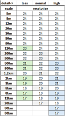
    I've set up 8 levels and mapped them to resolutions in the options file
    "levels = 0:24, 1:23, 2:22, 3:21, 4:20, 5:19, 6:18, 7:17".

    After a lot of trial and error, I've got the below table as a standard. Detail here is the setting in the watch in the menu Map-> Detail or it could also be configured in activity specific menu.

    With detail=normal I can control visibility from scale=120m, detail=less it's controlled from 80m and above and detail=high from 500m.

    As you also found out all poi's with code starting with 0x02yy behave strangely and most of them just show up to 80m regardless of style config. That can be used if you want that effect. For instance, if you have an object that you only want to be visible up to 80m, even if you are using detail=normal. I've moved many of the standard 0x02 to other codes in my style.

    Some examples from my style:

    place=town {name '${name}'} [0x0300 resolution 17-19 continue]
    place=town {name '${name}'} [0x0400 resolution 20-21]
    # town is visible with symbol 0x0300 between scale 5-20km and with 0x0400 between 1,2-3km

    highway=path & width < 0.8 [0x10e02 road_class=0 road_speed=0 resolution 24]
    highway=path & tracktype~'grade[3-6]' [0x10e02 road_class=0 road_speed=0 resolution 24]
    # small or bad paths show up on 5-120m with the symbol 0x10e02.

    highway=path {delete name} [0x10e02 road_class=0 road_speed=0 resolution 22-22 continue]
    # path uses symbol 0x10e02 on scale 500-800m and the name is deleted.

    highway=path {delete name} [0x16 road_class=0 road_speed=0 resolution 23-23 continue]
    # path use symbol 0x16 on scale 200-300m and the name is deleted.

    highway=path {name '${name}' | '${ref}' } [0x16 road_class=0 road_speed=0 resolution 24]
    # for the most zoomed-in resolutions, it should also show the name if available and if the watch 'feels for it'.

    Some symbols have the name show up as default and others not. I've not found a way to effectively hide/show. The only thing I can control is to hide the name, by deleting it. Then it's not showing up, but it's also not viewable when tapping the object on the map. Does anyone know of a way to show/hide without altering it?

    One other thing to keep in mind is the area/object priority in typ file. A couple of times that has given me strange behaviors when zooming in and out.