
Hi all,
maybe someone of you has some ideas:
- (BaseCamp +) MapInstall make problems, when I try to install OSM maps to my Fenix.
- OSM maps transfered via MTP are not shown properly
SW Versions and Information
- Fenix 11.28
- BaseCamp + MapInstall latest version
- Windows 10
Issue with MapInstall
- I Install OSM maps from freizeitkarte-osm.de regularly, they are also shown as intended in BaseCamp
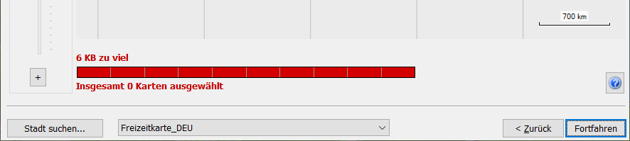
- When trying to install them to my Fenix, MapInstall directly brings a failure "6 KB too much".
- This while on the Fenix 14 GB space are free; no music, no other audio recordings, only plain training data stored on it.
- The map for Germany is 2.9 GB - so should fit perfectly well into the internal storage
- (and before anyone is guessing the PC also has more than enough space: C: has 230 GB left, D: 1,22 TB)
- This while on the Fenix 14 GB space are free; no music, no other audio recordings, only plain training data stored on it.
- When selecting all regions of Germany, it comes up with this ("2.79 GB too much"):
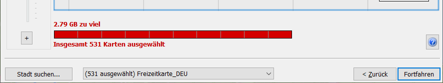
- Of course these data cannot be transferred, when MapInstall assumes that already 6KB are too much.
But why this problem at all? There is plenty of space; there is no other OSM map on the Fenix and it also does not - as the user manual says - suggest to delete anything for it.
OSM Map not showing correctly
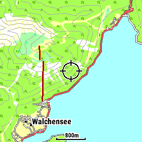
- As alternative I downloaded the maps as .img files from freizeitkarte-osm.de. I copied them via MTP to the Fenix into the GARMIN folder.
So far so good, but... - Example Walchensee in Germany:
Whenever I move the map, parts of it are shown properly, other useless.
Shown in the picture is the exact same location, the only thing that makes a difference, is moving the map a bit to the side.
So you can get from a corrupted map to a good map. If sliding back, it get's corrupted again. -->
--> 
What is the reason for that?
From MapInstall I saw, that there a region boundary was lying; but as all of this is covered in the .img file - what is also proven to be true when scrolling leftwards (everything is visible), and rightwards too (again, everything visible); only in the overlapping case it is screwed. - The same applies in non rectangle shapes:
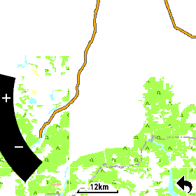
This is the south of Munich, Germany.
At this scale it should only show the roads, the Fenix is also configured to show minimal details, no boundaries.
For the north of Munich only the highways are shown, as it should be, but for the south this mess happens.
Any idea what is going wrong here?
Sorry for the extensive text, I thought I better provide as many information upfront.
If anyone has any idea, it would really be great to get some thoughts, if not even solutions for this 
Thanks

