Strage altitude data


Hi everybody
I have been using Garmin watches for years, mainly for running, hiking cycling

I bought Fenix 7 three days ago and made my first hike

I’m aware of some inaccuracy in altitude data, but this time I’m totally puzzled

I know for certain that the first couple of km, the trail I was doing climbs gently from 1000 to 1200 meters.
Instead, Fenix 7 data climbed steadily from 1000 to 1600
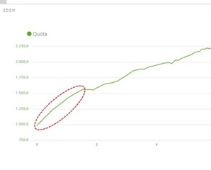
See here

As a result, I had for the whole trip both altitude and elevation overestimated by those 400 meters

In the reaming 10km recorded data seems to be 100% ok

Surprise came when I checked data back at home with connect

If I watch at the altitude graph it has that mysterious steady climb at the beginning


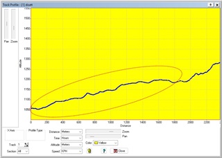
I then tried exported the gpx file from Connect and check altitude data using another software and … they are 100% correct! No such a mysterious initial climb…

Here is an altitude chart of that gpx with another software

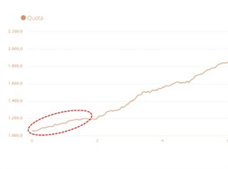
Moreover: if I import back that same gpx into connect… it works fine and data/graphs are correct

See here the gpx reimported in Connect

For your information
I have Elevation correction disabled in Connect


On the Fenix 7 altimeter I have
- Autocalibration on
- Sensor Mode Auto

Conclusion: it seems like in that case Fenix 7 is reporting wrong elevation data (both live during the trip and in summaries/Connect) while it is recording/saving a gpx track with the right altitude data

Any help is welcome

Nicola (Italy)

Top Replies

All Replies

  • Hi.

    forums.garmin.com/.../f7x-8-37---9-33-bugs-altimeter

    I will investigate what you say. In my case today it's still the same, I'm bored to see that Garmin didn't do anything about it.

    Best regards.

  • AFAIK, during activity altitude is measured by barometer, which is not very accurate (it can change with weather). Once activity is uploaded, altitude gets corrected and then synced back with the watch. If all that is true, it can explain your observation.

  • No. Generally a barometric altimeter is considered more accurate than GPS altitude data , especially catching all the small ups and downs (GPS vertical error can have 2 or more times the error than the horizontal). It does need to be calibrated to provide “actual” altitude rather than the net gain and loss and, as noted is impacted by weather changes. Depending on settings this is recorded in the fit file and is not the same data as obtained from the GPS. 
    by default, in Connect Elevation Correction is off for watches with barometric altimeters. If enabled then the GPS horizontal location is used with a DEMS dataset to determine elevation. 
    so there are 3 types of elevation data, barometric provides better overall gains and losses but for absolute values needs to be calibrated at the start and must occasionally recalibrate to adjust for weather changes. GPS data with “built in” vertical error or a lookup based on coordinate they will depend on the initial location accuracy and the dataset resolution (consider running along a cliff and your GPS is off by 3 meters putting your lookup location as down the cliff). 

    They all have issues so I know some of my statements are simplistic but with the OP, seeing a different chart with the GPX export is because it is showing a different set of the data - the GPS. IN CONNECT, enabling Elevation Correction does not sync back to the watch afaik. 

  • Thank for your detailed answer


    I just want to point out that:

    • The starting 1.5km of my hike goes from 1000m to 1200 meters elevation. I know it from several previous experiences and from topographic maps
    • The elevation on Fenix was roughly correct at the starting point (around 1000 meters). Anyway, I’m interested in elevation gain rather than elevation itself. That’s why I always used barometer rather than DEM/GPS with previous Garmin devices. In his case however is used Auto
    • In this 1.5km the Fenix climbed from 1000 to 1600 meters (400+) with no spikes or outliers but very regularly (see firs chart). The chart is from Garmin Connect desktop and elevation correction is disabled
    • A gpx obtained using Connect using that same activity has very different elevation data for that first 1.5km (1000m to 1200m, +200meters, so perfectly correct)


    So, my understanding is

    • Having chosen Auto instead of barometric elevation, Fenix 7 used a mix of elevations.
    • Being that trail in a wood and close to rocks Fenix made a mix of pretty correct elevations, or at least pretty correct elevation gains taken via Barometer with incorrect elevation via DEM (due to cliff) and GPS (due to wood/trees)
    • That incorrect elevation/gain is used live on the watch as well as in Connect (I guess it is a .fit file)
    • When I exported a gpx from Connect it DOES NOT transform the .fit file into gpx. Instead, it saves a .gpx with Barometric data


    Sounds weird…What do you think?


    Nicola

  • If you have not seen this yet check https://support.garmin.com/en-CA/?faq=d7G0fSGGJ98l1ZH9dyglZ6 that’s a short description of the options.  The auto mode tries to figure out if changes are due to air pressure changes or elevation changes.  Anytime the software tries to figure something out it sometimes messes up.  Given you are mostly interested in gain loss, not absolute, try Altimeter mode. Either manually calibrate before the activity or set it for nightly (so there are no adjustments during the activity). Keep in mind with these settings, especially on a longer run, weather changes will sometimes cause an issue. 

  • I have a F7X SS and like you (maybe), elevation gain accuracy is a higher priority than distance. If you're climbing on the same routes then you're able to track the consistency of elev gain data from the same activity even with varying weather conditions

    Try these steps:
    1. Set Altimeter Auto Calibration to OFF
    2. Set Watch Mode to Altimeter
    3. Wrap a BUFF scarf on your wrist in front of the watch effectively shielding the barometer opening from rain, wind and sweat.

    I have found through many months of testing that elev gain data is so inconsistent bordering erratic that I documented my findings with various ideas and happy to report this approach has proven consistent. Attached example of two runs three days apart—one extremely hot the other rainy. I have seen this issue happening across friends' Enduro and Fenix 7 they too have found using a scarf to fix their watches reporting higher than expected elev gains. Activities we've collectively tested are Trail Running and Biking (road and MTB). Let me know if this works for you.