F7 9.33 elevation problem

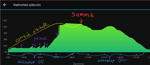
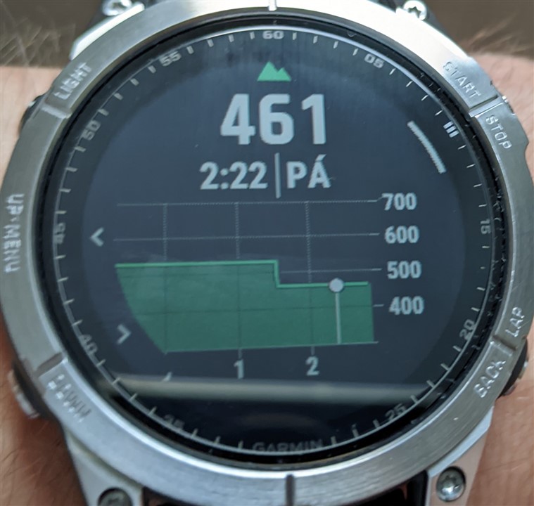
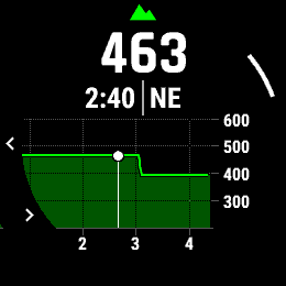
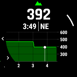
Last few days my activites elevation starts at 384m instead of right 450m for all activities and various gps settings. The auto calibration at night makes huge shifts from right 463m to 392m. The shift used to be about only 5m before.

The only help is to turn off auto calibration and then, when watch asks about new elevation while starting the activity, choose option to get right elevation from GPS. Then the watch gets the right elevation immediately.

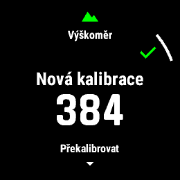
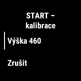
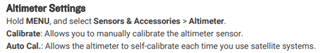
But this was not necessary before, the elevation was always changed to right value at start of an activity. Even the manual says that:

If I didn't look at my recent activities, I wouldn't even noticed that problem. But I was surprised with strange bad elevation values at work and at home. The elevation is wrong all the day.

  • 10 more Tests with full sat coverage, known eleveation, no houses around: "no auto calibration at days": maximum derivation 20m, "auto cal" on: maximum 10m. Not in your range & with that few (10 is few statistical spoken) messurements not a reason to call it buggy in my case.

    I'll keep checking you got me curios.

    DEM btw. always exact to the meter, no matter what mode for calibration, as to be expected if principle of operation is maintained.

  • I'll keep checking you got me curios.

    GrinThanks for all research. I'll try to record a video, when my problem appeared again.

    DEM should be taken from maps, from elevation data (contour lines).

  • DEM should be taken from maps

    Well not quite: maps take the data from the corresponding - let's call it matrix or simple database as the DEM calibration does too. Otherwise it would take way to long to first reead the map at your given point and than extract the data from it. Then: the maps contour lines are in fact interpolations of those data b/o best I ever saw in public use are those 6 meter rasters in switzerland (of course, where else in the world ;-)) Otherwise it would be called contour dots. ;-)

    I know, sounds like inch pinching and is in a way but when you analyse a problem you ought to be as precise as possible since you wouldn't know beforehand where exactly in between your problem is.

    Some words in addition: I don't think you have to video track the problem since you described it quite clear.

    With I wrote I try to nail it a little: Obviousely you loose proper elevation data during activity tracking. I'don't for what I can say so far BUT I use tracking mainly on plains (water, high in the air) where we can expect a superb satelite covering and thus the difference between sat only and DEM should not that important as if you take a trail run in the České Švýcarsko with trees around you. So me not OBSERVING the problem doesn't mean it isn't there - it's just not that relevant to my usage pattern.

    When I should nail the problem further (hoping that developers read those remarks too, thats why I try to be as detailed as possible): I could be possible that for tracks GPS only is used and not the DEM. That would be a bug and it should be(with all the information provided) quite easy to be confirmed or denied by development.

    Your crazy peak in pressure is probably to be explained by GAJINs remarks. Remember last time when your girl shut the door of your beloved classic car way to hard? Not only the pain but the obvious pressure in your ear? 16hPA are - while an important difference for weather prediction - not much where real pressures are observed. That indeed you should try to reproduce - if barometric sensor is that fast as Garmin - Chris suggests - that might be the whole explanation there.

    @all who live preferably in around 400m heights (key word: linearity of sensors, might always be taken into consideration) and do trail activitys with real differnces in elevations, preferably with suboptimal satelite contact: Do you oberserve similar problems? Pls. let Honza know.. Might help to close in to the problem. 

  • Hi Erik, thanks for the lot of informations. One hour ago, I returned from running. Little bit upset again :-). I got right 457m elevation before clicking start and select Running activity. But running activity started at 382m and ended also on same bad 382m instead of 457. But the elevation curve seems right but with offset. Maybe I'll turn auto calibration off for some time and enter elevation before activities. And hope that Garmin guys find some error elsewhere. There are new threads appearing with barometer problems...

  • I'll keep my fingers crossed. 180m in difference is - well - a lot. Even with all explanations about principles.

    BUT: catching fire there I did some research myself inbetween with a GPS gadged for railway contruction whith which it is up to you to choose every single satelite system available w/ & w/o DEM. So I did exactly that:

    3. GALILEO was lazy and only had a range of 20 meters up and down

    2nd place went to GPS: 35m

    1. GLONASS was most active and won by flip-flopping around 70meters

    All on a plain, of course with no DEM which immedialtely improved data to the meter with all of them. in less GNSS-friendly environments that might be worse

    This just as an addition.

    You saw barometer threads already? OMG. This is heating up. However to understand your pressure peak and to get a better handle on the meaning of the numbers it might be helpful to remember the german DIN normnativ with the unit atü or technical athmosperes which essentially meant the over pressure relatet to the normal pressure with 1 Athmosphere over pressure (at) meant roughly double the normal pressure. My cars tire has around 3 at. 1at equals roughly 1000hPa or exactly 980 ,665hPa. Since you probably have a good sense by experience for a typical technical overpressure: 18hPa is exactly 0,0183 at more pressure. not much. When you haven a room with AC on full like me in summer and no AC in the neighboring room and close the door in between you can measure for a moment an overpressure of almost 1at/1000hPa means almost 2000hPa and have to apply force to close the door from inside the AC room. This just to illustrate that a closing door in a bus easely can account for that. So it might be helpful to see wether you can see spikes like that when you are outside. THAT to the contrary would be a HUGE change, to huge to be natural and proof of just another bug. ;-)

    Cheers Erik

  • Thanks again for the research! You did interesting work. I know the pressure spikes can show time to time, I'm ok with that. I have problem only with the beginning of activity, which shift the altitude from previous right value to something bad.

    Today 3,5 hours in car and I got right altitude in the finish within 10 meters. With no calibration since yesterday. Will see tomorrow's way backSlight smile.

  • I think the autostop(autopause to be correct) feature is causing problems since 9.33. When the feature is ON, every pause it "calibrate" altitude back to start position. On the sample the path to summit is the same for up and down, graph should be mirrored. On the summit I turned off the autopause function and the problem si gone.

  • ...and since autopause is off by default with my personal activities I'd never run into this ugly problem.

    Great job. I'm looking forward to Honzas experience with that.

  • Oh God, one will still didn't solve first problem and next problem appeared... I'll bet that there are more problems with altimeter in 9.33. In other topic, someone compare altitude with Edge computer and gets horrible results. I'm happy that I can't compare my watch with other Edge computerGrin. I have auto pause off, but will try that on next run. 

  • Night on hotel. Shift from right 527m to wrong 462m. Seems like the watch thinks, that I'm at home, where 462m will be right. But I have everything disconnected at night.