
So I have been on a nice vacation - and recorded multiple activities on my watch. Is there a good way to plot them altogether on a signle map? So kind of connecting the dots, showing me on one map all the activities that I did?
So I have been on a nice vacation - and recorded multiple activities on my watch. Is there a good way to plot them altogether on a signle map? So kind of connecting the dots, showing me on one map all the activities that I did?

If they were contiguous then you can use fitfiletools on the interweb to join them.

I currently don't have my computer with me, but as far as I remember Garmin Basecamp can do that.
Garmin Explore can also do that (web and app).
My favorite app for route planning is Locus Maps, it…

Thats where garmin basecamp shines: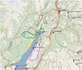
Other options are strava personal heatmap (w/ premium) or Locus map on Android devices.
| Arabic | Hebrew | Polish |
| Bulgarian | Hindi | Po… |


