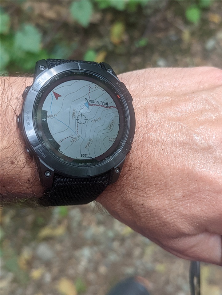
Fenix 7 is advertised as an ultimate adventure watch but the maps have poor readability for activities on trails

The above picture shows my frequent frustration when trying to use maps on forested trails. This picture was taken in the middle of the day while running on a forested mountain trail.

Can you see the trail going to the left without zooming the picture? I can't. And this is what Garmin calls High Contrast map theme. I actually took some time to get rid of the glare and reflections before taking the picture, but even without that trails are hard to see when not in a bright sun. It is even harder to see when moving faster e.g. trail running. 

The main problem is that trails are rendered with a single pixel wide dashed line and that just doesn't stand out enough especially when there are a lot of contour lines. What Garmin should do is to render trails with thicker lines. If Garmin doesn't want to do that by default, perhaps that should be done in the High Contrast theme only.

Can anyone from Garmin comment about this? By the way, Enduro 2 is going to have exactly the same issue.

  • You can also install over the top of your map, a custom trail map with clearer track paths like I have in my picture of my older Fenix 6x Sapphire.... Or download any OSM map of your choice in the right format... These watches are so versatile, its up to you to make them into what you want..

  • Which one do you usually use( I mean OSM map)?

  • Please, share the name of the maps you're using in that picture. 

  • I usually use Frikart Topo Summer 1, or Talkytoaster TT50 DEM PRO...Userbeam and some others... I like to see my changes applied. (I like to map my area and contribute to OSM.) 

  • I'm not sure what combination I used... It was a long time ago.. But I can send you a link to my Facebook forum page with all the map links if you like... all the maps I use are listed there as well as others who have contributed to the announcement post...

  • Thanks a lot. I thought it could be Frikart map but not sure.ThumbsupThumbsup

  • It's ok. Thank you. I've just wanted to know which map it was that one from the picture you uploaded. I have a Web page with links to all the maps you mentioned and others. I will try frikart. Cheers

  • I think that is the wrong approach in general. Garmin advertises this watch as an ultimate adventure watch with the maps preloaded. That often means navigating in wilderness on trails, but as I shown above trails aren't very legible on the map because of how they are rendered.

    What you suggest that I work around the problem by downloading alternative maps, which I can. But there is a number of issues. Most of these alternative maps like Talkytoaster go for a high number of details. What I really need is fewer details but high readability of a few important elements like trails, creeks, summits, etc - something that that is truly usable (glanceable) at high intensity activities like fast paced trail running. Also, alternative maps often cost additional money.

    I am not looking for a workaround for my problem. What percentage of Garmin users is even capable of doing complex workarounds like that? I am looking for Garmin to address this problem for all users by making trails more legible on the maps (possibly as an option or a map theme). How hard it can be for Garmin to address?

  • It's the best approach I can think of as a user... I do agree with you , it would be better and extremely easy for Garmin to change the tracks to be more clearer... and then you wouldn't need layers... adding map layers will negate routing on the watch... I use a layer only for courses or just hiking on the fly.... Then we could have routing again... I don't know why Garmin and  other map developers choose paths and tracks types that are hard to see leaving them like they are on OSM. 

    The map type file was made by another forum user, anyone can download it... There's a thread in the forum here somewhere... Its not a theme unfortunately but another map layer.

    The way to do it would be to download a transparent trail map from say Frikart for free, then change it with the map type file.... I could try and search for the post here I guess. 

  • Maybe I just have really good eyes, but personally I have no issue seeing the trails on the maps, including in the photo posted in the OP. It never bothered me that the trails were only 1px wide.

    However, I absolutely DO agree with the sentiment that Garmin should provide us with more map controls to allow us to change how things are rendered. It's not enough to just give us a small list of pre-configured "themes", I want to have more control over what things I want to appear on the map (and what things I don't), colors, line thicknesses, etc. Most handheld hiking GPS units have this functionality, so it would be nice for the watches to also have it.