There is a GPS problem with tunnels and so

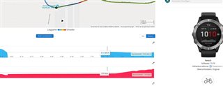
To mention it again. Between Fenix 6 and Epix 2 on one and the same lap are >500m offset at 20km.
Take a look at the pictures. I have 2 tunnels on the way (Frankfurt airport). Both are 200 and min 300m long.

With the Fenix 6 I drive, as with the Epix 2, with 4.63km pure. I come but, correctly, out of the tunnel with ~5.1km.


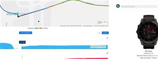
With the Epix I go in with 4.64 and come out again with 4.67km. That's nonsense. But explains why the devices have such a difference. The Epix can not calculate tunnels out. 


  • If im right that sould be also if i walk throu? But, Fenix 6 recognzie that since years.

             <Trackpoint>
                <Time>2022-03-25T14:45:44.000Z</Time>
                <AltitudeMeters>91.5999984741211</AltitudeMeters>
                <DistanceMeters>4631.22998046875</DistanceMeters>
                <HeartRateBpm>
                  <Value>119</Value>
                </HeartRateBpm>
                <Extensions>
                  <ns3:TPX>
                    <ns3:Speed>1.1710000038146973</ns3:Speed>
                  </ns3:TPX>
                </Extensions>
              </Trackpoint>
              <Trackpoint>
                <Time>2022-03-25T14:45:53.000Z</Time>
                <AltitudeMeters>91.80000305175781</AltitudeMeters>
                <DistanceMeters>4631.22998046875</DistanceMeters>
                <HeartRateBpm>
                  <Value>122</Value>
                </HeartRateBpm>
                <Extensions>
                  <ns3:TPX/>
                </Extensions>
              </Trackpoint>
              <Trackpoint>
                <Time>2022-03-25T14:46:02.000Z</Time>
                <AltitudeMeters>92.0</AltitudeMeters>
                <DistanceMeters>4631.22998046875</DistanceMeters>
                <HeartRateBpm>
                  <Value>124</Value>
                </HeartRateBpm>
                <Extensions>
                  <ns3:TPX/>
                </Extensions>
              </Trackpoint>
              <Trackpoint>
                <Time>2022-03-25T14:46:10.000Z</Time>
                <AltitudeMeters>92.19999694824219</AltitudeMeters>
                <DistanceMeters>4631.22998046875</DistanceMeters>
                <HeartRateBpm>
                  <Value>123</Value>
                </HeartRateBpm>
                <Extensions>
                  <ns3:TPX/>
                </Extensions>
              </Trackpoint>
              <Trackpoint>
                <Time>2022-03-25T14:46:17.000Z</Time>
                <AltitudeMeters>92.5999984741211</AltitudeMeters>
                <DistanceMeters>4631.22998046875</DistanceMeters>
                <HeartRateBpm>
                  <Value>123</Value>
                </HeartRateBpm>
                <Extensions>
                  <ns3:TPX/>
                </Extensions>
              </Trackpoint>
              <Trackpoint>
                <Time>2022-03-25T14:46:25.000Z</Time>
                <AltitudeMeters>92.5999984741211</AltitudeMeters>
                <DistanceMeters>4631.22998046875</DistanceMeters>
                <HeartRateBpm>
                  <Value>123</Value>
                </HeartRateBpm>
                <Extensions>
                  <ns3:TPX/>
                </Extensions>
              </Trackpoint>
              <Trackpoint>
                <Time>2022-03-25T14:46:27.000Z</Time>
                <AltitudeMeters>92.5999984741211</AltitudeMeters>
                <DistanceMeters>4631.22998046875</DistanceMeters>
                <HeartRateBpm>
                  <Value>124</Value>
                </HeartRateBpm>
                <Extensions>
                  <ns3:TPX/>
                </Extensions>
              </Trackpoint>
              <Trackpoint>
                <Time>2022-03-25T14:46:33.000Z</Time>
                <AltitudeMeters>92.80000305175781</AltitudeMeters>
                <DistanceMeters>4631.22998046875</DistanceMeters>
                <HeartRateBpm>
                  <Value>125</Value>
                </HeartRateBpm>
                <Extensions>
                  <ns3:TPX/>
                </Extensions>
              </Trackpoint>
              <Trackpoint>
                <Time>2022-03-25T14:46:41.000Z</Time>
                <AltitudeMeters>92.80000305175781</AltitudeMeters>
                <DistanceMeters>4631.22998046875</DistanceMeters>
                <HeartRateBpm>
                  <Value>125</Value>
                </HeartRateBpm>
                <Extensions>
                  <ns3:TPX/>
                </Extensions>
              </Trackpoint>
              <Trackpoint>
                <Time>2022-03-25T14:46:44.000Z</Time>
                <AltitudeMeters>93.0</AltitudeMeters>
                <DistanceMeters>4631.22998046875</DistanceMeters>
                <HeartRateBpm>
                  <Value>122</Value>
                </HeartRateBpm>
                <Extensions>
                  <ns3:TPX/>
                </Extensions>
              </Trackpoint>
              <Trackpoint>
                <Time>2022-03-25T14:46:50.000Z</Time>
                <AltitudeMeters>93.0</AltitudeMeters>
                <DistanceMeters>4631.22998046875</DistanceMeters>
                <HeartRateBpm>
                  <Value>123</Value>
                </HeartRateBpm>
                <Extensions>
                  <ns3:TPX/>
                </Extensions>
              </Trackpoint>
              <Trackpoint>
                <Time>2022-03-25T14:47:02.000Z</Time>
                <AltitudeMeters>93.19999694824219</AltitudeMeters>
                <DistanceMeters>4631.22998046875</DistanceMeters>
                <HeartRateBpm>
                  <Value>123</Value>
                </HeartRateBpm>
                <Extensions>
                  <ns3:TPX/>
                </Extensions>
              </Trackpoint>
              <Trackpoint>
                <Time>2022-03-25T14:47:03.000Z</Time>
                <Position>
                  <LatitudeDegrees>50.0214546918869</LatitudeDegrees>
                  <LongitudeDegrees>8.523244773969054</LongitudeDegrees>
                </Position>
                <AltitudeMeters>93.19999694824219</AltitudeMeters>
                <DistanceMeters>4670.240234375</DistanceMeters>
                <HeartRateBpm>
                  <Value>123</Value>
                </HeartRateBpm>
                <Extensions>
                  <ns3:TPX>
                    <ns3:Speed>3.125999927520752</ns3:Speed>
                  </ns3:TPX>
                </Extensions>
              </Trackpoint>

  • All the errors in the GPS, but also in the altitude table etc. are unfortunately absolutely frightening.

    Knowing Garmin, they will not fix it.

  • Once you are out of the tunnel it should add the distance from where you lost GPS reception to where you get reception again unless that is an unrealistic change.

    I would open a support ticket and I would also try other activity types (still biking) to see if this is specific to the bike activity or not.

  • I must admit that I hoped that I am not the only one who has a tunnel on his route.Ticket oder Mail ist written

  • Same....all the time. I wont stop till Garmin said it is a GPS Chipset bug:

    - they cant fix

    - they will fix

    https://forums.garmin.com/beta-program/fenix-7-series/public-beta-reports/i/public-beta-8-35/trackingproblem-in-tunnels-with-bike-still-exist

    As i opend a case at the german support they say that the watch must first get used to me. Realy, i got the original mail. Driven some hundreds of kilometer and nothing happens. Looks like the watch dosent like me.

    Tunnel is 400m long. I have 3 tunnels on my round.

  • The gps signal can’t find you in a tunnel.  It’s common knowledge.   What are you whinging about here.

  • Buy a speed sensor if you want to measure the distance without GPS signal. 

  • He's not talking about GPS signal but on how the points get connected before/after the tunnel.

    With F6 it was ok, with Epix 2 not ok and, from what i understood, it's happening only with bike activity.

  • Nice. So the Fenix 6 have som magical Sensor inside? Because with the Fenix 6 the track was correct.
    The GPS Chipset inside the Fenix 6 was able to connect and measure the distance of the two points.

    I drive thru this tunnel dozen times with the fenix 6 (i got 3 tunnels on that round) and lost near 700m....no critical problem, but the Fenix 6 can handle this.

  • As you can see here (i cant Upload direct in the answer) with the Fenix6 it was perfect

    abload.de/image.php
    abload.de/image.php