This discussion has been locked.
You can no longer post new replies to this discussion. If you have a question you can start a new discussion

Almost 3GB gmaprda.img file mandatory?

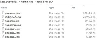
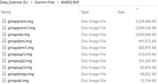
I have noticed that o MARQ watches there is img file named gmaprda.img that is not present on Fenix 5 plus series. Even after deleting the gmaprda.img file maps still work. Could someone please explain what this "Road Drawing Accelerator" file does, is it mandatory and why it has not been included on Fenix 5 plus?

  • Former Member
    0 Former Member over 6 years ago

    Im going to take an educated guess and say that Garmin have separated the road data from the terrain map tiles to expedite the rendering of road data when zooming and panning.

    Are roads still rendered after youve removed the file? If so, do the maps appear to render both the roads and terrain as tiles as has always been the case with the 5 Plus?

  • Thank you for your thoughts. I have also compared the img files from both watches. This is on "old" 2018.20 TOPO Europe maps, but as you can see the main map files are same size on MARQ and on Fenix 5 plus. gmapdem1, gmapsup1, gmapsup2, gmapsup3 are for golf courses. If something was separated from the main maps, the size of two main img files would be different, but it is just the big gmaprda.img file that has been added on MARQ (same on FR945).

    And, yes I can still see streets and roads with gmaprda.img removed from the watch. How can I check if they are rendered as tiles?