Very inaccurate KM count

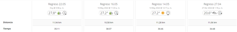
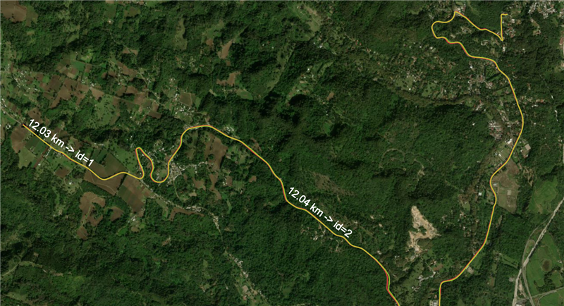
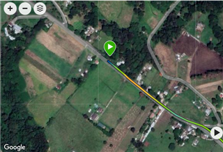
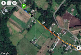
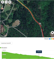
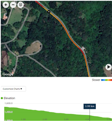
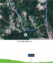
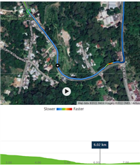
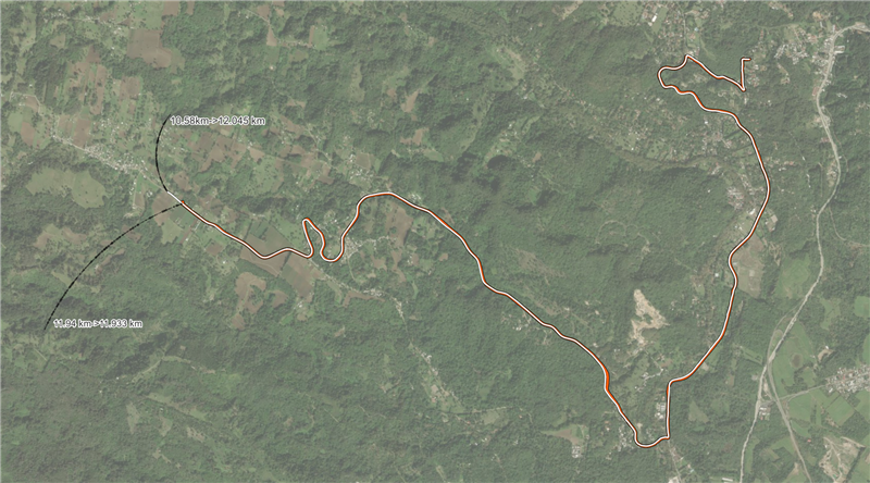
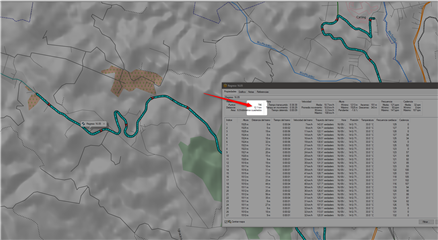
Hello. There is a route that I do very often. It always starts outside my home, and ends at the same point. No deviations.
I can understand that there are differences when it comes to registering the total number of km traveled, but only in the order of tens of meters, not more than 1 km!
Which may be due?
I still think that the speed sensor works very badly, and it always affects the count. But for the last 4 records, I left it on auto for wheel size. Because it never counted me correctly, compared to a forrunner 245.
Thank you

  • I have tried to download 2 of the 4 activities, in GPX format. Import it into GIS software, and calculate the length of the line. It is in 2D, although I asked the watch to record 3D, but it is not relevant to our case.
    The relevant thing is that in GIS software, the 2 routes come out almost identical, and it is what I would expect to see in Garmin Connect.
    I ask: why is the mileage reading very different in Connect (1 km less than in QGIS) and also so variable from day to day?
    With that kind of error, I'm doubting all the records of my segments, too. And you lose confidence in the product
    I hope you can give me some help or idea!
    Thank you very much

  • Did you try riding without connecting the speed sensor to Instinct, to isolate whether the problem comes from the sensor, or rather from GPS drop-outs? When the watch loses the GPS signal for a moment, it does not simply interpolate the distance between the closest known GPS points, but rather uses some estimation based on the average speed. That then leads to the discrepancy between the distance measured on the map, and the one reported by the device. It would be interesting to see whether the speed sensor has any influence on the accuracy or not.

    Could you share links, for example to the first and to the second activity from the screenshot (and making it public)? The background data available on the web pages of those activities may perhaps give some clues about the culprit.

    Generally, my Instinct, as well as Instinct 2, tend to underreport the distance by up to some 5% at running activities. I use the function "Correct Distance" in Strava to get a more realistic number, and I then edit it in Garmin Connect by hand. Not an ideal solution, but a workaround that helps me keeping the data more consistent.

    However, at cycling, in contrary to running, the distance reported by my Instincts, usually fits the corrected distance much closer - within 1%, which is very well acceptable. On the other hand, my rides are mostly in open terrain, not in mountain valleys, so it can be also because of that.

  • Thanks for the ideas.
    1) the route is completely clear, they are not trails, but a wide road. It's a mountainside but if it loses points there, I can't imagine how bad it would be in cliff areas.

    2) I am going to try without a speed sensor, and compare about 4 times.

    3) It is not acceptable that a gps instrument specifically designed for outdoor, I have a 5% underestimation ... or that the user should waste his time correcting ... I think he will agree with me. But if a very low precision in repeating the activities is added to an underestimation, we obtain an instrument that loses much of its potential and objective.
    I did a 82km ride (real with GIS) and garmin recorded 79.9.
    I'm not complaining about that. It is a discrepancy that does not affect me in the least, because it is not a training route, it was just a walk.
    But if in 12 km, I lose 1 or almost 2 .... well, it is not viable.

    4) sorry, but I don't know how to generate a link to my activity to share it, I've never done it... could you tell me how to do it?
    Thank you very much!

  • OK, I measured and compared both tracks. They are not perfectly identical, but the difference is just ~150m at the start, and around ~50m at the end. Paradoxically, the track of longer activity of 11.94km is actually ~100m shorter than the one of 10.58km. The true length of the GPS track at the 11.94 km activity is 10.77km, while at the shorter activity of 10.58km it is actually those 100m more - 10.87km.

    I searched the activity for some drops of GPS signal, pauses, or other similar abrupt loss or increase of the distance, but in fact the inaccuracies are continuous, and in both direction, during all the activity. See below a few screenshots. The longer activity of 11.94km is always on the left.

    On the first pair of screenshots, you can see the 150m difference in the starting point. Nothing wrong here yet:


    The second set demonstrates the situation after 1km. The difference of the distance grew considerably from the original 150m to some 300m:


    And now, the situation at the km 6 - the difference is already reversed - the first activity, instead of being 300m ahead, as at 1km, is now some 200m behind (so some 500m difference to the situation at km 1, and ~350m in comparison to the start)! 


    Well, I could go on, but it looks apparent that the problem does not come from the GPS, but rather from the Speed Sensor 2, reporting continuously wrong distance, with errors in both directions. Are you sure you installed it correctly? Isn't it slipping on the wheel hub, when braking or accelerating? Definitely try a few rides without it.

  • ... also, when using the Speed 2 sensor, make sure you disable the automatic calibration, and use a fixed wheel size instead! Adjust the wheel size slightly, if the result does not match the reality - it may also change slightly depending on the state and pressure of the tires!

  • Thank you so much, because you took the time to do a really thorough comparison. I really appreciate your availability.
    It is clear that the problem is the speed sensor. It always gave me reading errors, with absurd speed spikes.
    For months I left it on automatic. Then I tried to adjust the size of my wheel, but it was impossible: although I made several measurements, the activity always gave brutal variabilities of distances, compared with my wife and hers for her 245 runner. Doing a ride together.

    I already removed it from my MTB, and I will do new tests.

    What seems illogical to me is that a speed sensor influences the distance record...they should be two parameters that are recorded independently, but in this case, it is clear that the speed sensor has a higher hierarchy than the GPS distance. I don't like that way of working, that's why, as of today, I won't use it anymore, it doesn't give me anything.

    A detail: the GPX layers, in a GIS system, must be projected to UTM before calculating the 3D distance.
    The activity that marks 11.94 km, in fact QGIS or ARCGIS measure it as 11.93...... km

    The activity of 10.54 km is the completely wrong one, because it actually measures 12,045 km. As you just realized, it is completely meaningless, the shortest activity is actually the longest journey.

    I will do several tests, and I will update this post! Thank you very much for all your help and availability!

  • It's very weird. the activity that marked 10.54 km, it is enough to open it in BASE CAMP, to have a distance of 12 km!