What should the Auto Cal. function do?

What should the Auto Cal. function do?
The manual says "Allows the altimeter to self-calibrate each time you turn on GPS tracking."
But when I set manually wrong altitude and start the Bike activity with GPS, nothing changes.


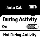
Did I miss something?

(I have still 12.00  firmware version)

Top Replies

  • But when I set manually wrong altitude and start the Bike activity with GPS, nothing changes.

    That is how it is designed to work. The manual calibration prior the start of the activity is…

All Replies

  • But when I set manually wrong altitude and start the Bike activity with GPS, nothing changes.

    That is how it is designed to work. The manual calibration prior the start of the activity is the highest priority source of the elevation to calibrate to. The priority list as shown below comes from the document Troubleshooting the fenix 6 or quatix 6 Series Altimeter and Barometer, but it is certainly very similar or identical at Instinct, too:

    1. Manual calibration immediately prior to starting the activity
    2. Prior manual calibration point at the same location
    3. Recent manual calibration, if the quality of the calibration is determined to be good enough
    4. Map data (DEM), if available
    5. Prior Connected DEM point at the same location:
      • Connected DEM refers to elevation data from the Garmin Connect app on a paired smartphone
    6. Connected DEM, if currently connected to a phone
    7. Prior GPS point at the same location
    8. GPS, if a good fix has been acquired:
      • After acquiring a GPS fix the timer ring will turn yellow. At that point, it can take up to 30 seconds for the GPS elevation to settle. If vertical speed settles to less than .1 m/s the GPS elevation data will be considered good enough use for altimeter calibration.
      • Before starting the timer, the elevation data field on the watch will preview the calibrated elevation
  • Thanks. I did not find these details in the manual Slight smile.
    I would like to know if it is possible to record the altitude during an activity from GPS and not from altimeter, if I wanted.

  • I would like to know if it is possible to record the altitude during an activity from GPS and not from altimeter, if I wanted.

    You can toggle between the barometric elevation and the topographic elevation profiles in Garmin Connect Web, on the page of each individual outdoor activity, with the help of the option Elevation Correction (accesible underneath the watch image on the right).