Wrong points in GPS trace

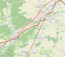
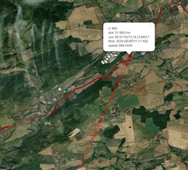
Hi, I have a Garmin Instinct, on v10.0. The other day I did a Via Ferrata, and my watch recorded the following:

connect.garmin.com/.../5694869669

(I hope you can see it)

Now, I can assure you that I did not fly across the valley in a straight line to then come back to the same place. Those GPS points are definitely fake.

Has anyone come across a similar situation? Any way of fixing it?
Thanks!

  • Being on a rock wall, or in a canyon will obstruct the connection to many GPS satellites, so such GPS errors are inevitable even with the best hi-tec devices, and it is not surprising a watch with a maximally miniaturized GPS receiver fails too. Setting up the option GPS+Gallileo can perhaps help a little bit, but if the obstacles obscure significant part of the sky, there is little chance for much improvement.

  • Thanks for your reply!

    That makes sense, in fact the other time this happened was also on a Via Ferrata, where there part of the sky is 'blocked' by the wall.

    What is suprising for me is that I would expect that in the places with bad GPS signal, it would just lose the signal and not give a position. Instead, it gives a wrong position.

    It would also be nice if you could edit out this points in Garmin Connect, but I think it's not possible.

    Cheers.

  • What is suprising for me is that I would expect that in the places with bad GPS signal, it would just lose the signal and not give a position. Instead, it gives a wrong position.

    The watch does not completely lose the signal to all satellites. They are just less of them, and most of them are on one part of the sky. It means the device can still calculate the position, with a smaller accuracy. Sor for example instead of the standard accuracy of some 5-15m, the position is acquired with the accuracy of couple of tens of meters (or perhaps even more in some cases). And since there is no absolute referrence, the device does not really know how exactly accurate it is at that very moment. It can only guess it. If the number of satellites drops beyond any acceptable threshold, the device drops the signal and pauses the position recording.

    It would also be nice if you could edit out this points in Garmin Connect, but I think it's not possible.

    If the offending points are at the beginning or at the end, you can use the Trim function, and remove those parts.

    Otherwise, you can export the activity and edit it in an external program, or even by hand in a text editor if you have some experience with XML (for the case of GPX and TCX activity file formats). Some services, like for example the one at plotaroute.com are capable to work with the native FIT files, which is certainly preferable.

    You could also use the Section Remover at https://www.fitfiletools.com/, which works with the original FIT files.

  • I have seen this only twice, it's quite rare. I suppose GPS devices have some  mechanism how to avoid such unreliable results, so bad coordinates are simply not recorded, as you can see on this map from www.sunearthtools.com . In this case, I was sitting in the train. You can see another 3 sections, where no point is recorded, which is much more usual. Instinct recorded those wrong points, though the speed 946km/h would be necessary to move like this Slight smile. Those "jumps" are about 6km long, I am not sure if they are added to the measured distance. Instinct watch and connect.garmin.com show 120km for the original .fit file (and max speed 79.7km/h), 127km for .gpx created from the original, 115km for .gpx where I deleted those 3 wrong points manually. Rolling eyes