Question about Elevation corrections

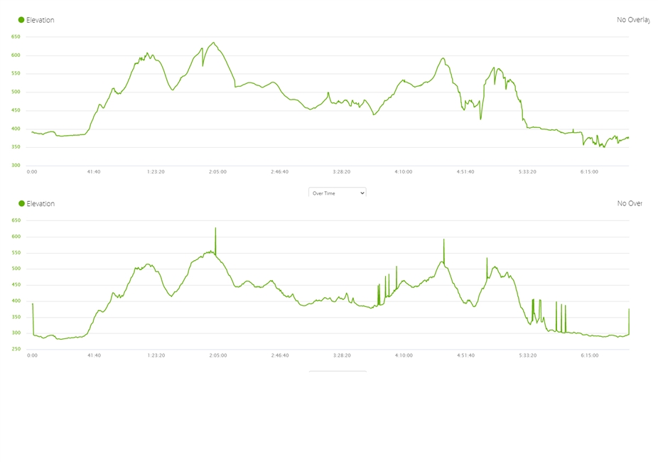
The first graph is straight from the Activity without correction. There is a minor issue at about 1:50, then 5:00 and maybe two sharp dips 5:10 and 5:15. Also the last 40 minutes were pretty flat.

After having enabled the corrections, however, the graph doesn't look much better. All of the sudden I have weird spikes all over the place even though most of the previous sharp dips have been evened out correctly.

Also elevation gain differs by quite a lot. Device says 1200m but with corrections it's 900m. Now I'm not really sure which one to believe

  • When you enable the Elevation corretion, the algoritm looks up the topographic elevation using the GPS coordinates, but if the are some GPS signal drop outs within the activity, it resorts back to the barometric data. If altimeter is not calibrated, it then leads to this kind of spikes in the graph. You will avoid them if you properly calibrate the altimeter before the activity.

  • In general (but always with  exceptions), the barometric altimeter will provide decent  overall gain and loss with more precise accumulation of the smaller ups and downs than the other methods (GPS or corrected by DEMS data), unless during periods of rapid weather changes or longer activities where drift will take place (ask a Pilot how often their barometric altimeter is calibrated from dedicated sources).  If not calibrated it is still true that the overall gain/loss will be decent, only the given altitudes will be shifted.  This can be clearly seen in the above graphs where the spikes in the corrected graph match the altitude  in the first - as pointed out by trux, and the general shift is about 100m.  In Connect the correction is disabled by default for any watch with a barometric altimeter and enabled for those without - reason being is that GPS altitude can be 2x or more inaccurate than the GPS horizontal accuracy so it can be really bad providing accurate overall net gain/loss. 

    Corrected data relies on the accuracy of the horizontal GPS for location and then the accuracy/resolution of the DEMS data for the area - the latter can be very good in some areas and really bad in others.  With the regular GPS errors it is not uncommon to see spikes and dips when trail running in really hilly areas as a small offset in GPS will result in a major drop/gain in elevation based on DEMS (run along a cliff edge).

    You will get lots of different opinions on which is better, when/how to calibrate etc.  It is surprisingly difficult to get really accurate elevation data from a watch!  I think it also depends on what you want.  For my use case, i occasionally manually calibrate my watch at home but do not really bother to specifically do it for an activity as i do not really care about actual elevation, only general gain/loss.  If you needed actual elevation data in the mountains for safety and navigation, you would likely do this differently (and not sure I would count on my watch for this anyway)!

    I can't confirm trux's explanation of Connect resorting back to barometric data when GPS drops out but the graphs certainly support this.  IMO it is not a good way to do it given the choice to correct means you do not want to use the barometric altimeter data so I would have expected some form of extrapolation between points to avoid spikes but I don't write the code and anyway it was done would run into some situation that messed up things.

    Bottom line - if anyone asks, spit the difference - 1,105 m!

  • As noted by razmichael the barometric altimeter is usually more correct, in particular in mountains where the DEMS data are not precise enough and where even with perfect DEMS data, a common 10m error on GPS position might result in huge errors in elevation.

    However, given the issues of the barometer on the Instinct (which are widely discussed on other threads of the forum), you may not always trust the elevation graph given by the watch. In your case, the issues you noticed at 1:50 or 5:00 typically look like you blocked the sensor hole with your wrist, causing a temporary higher pressure. The result is that the watch thinks you went 50m down then up again, this several times, explaining the global difference in the computed ascent.

    So for these particular graphs I would trust more the 900m ascent computed by GC. I don't know precisely the origin of the weird spikes in the corrected graph but for my activities I noticed that they are not taken into account to compute the global ascent of your activity.

    If you observe this too often, try wearing your watch on your right wrist.

  • I don't know precisely the origin of the weird spikes in the corrected graph

    As I wrote in the initial post, I know with absolute certitude that the spikes are caused by the loss of GPS signal (in some cases due to the lack of DEM data at given position), and the consequent resorting of the algorithm from topographic (DEM) data to barometric data, while the barometric altimeter is not correctly calibrated (in this specific case it is calibrated some 80-100m above the true altutude).

    You see it best when you superimpose both graphs, like I did for example in the following thread:

    https://forums.garmin.com/outdoor-recreation/outdoor-recreation/f/instinct/210640/problem-with-distance-and-pace-measurements-on-instict/1041695#1041695