Instinct - 6.52 Beta Release

Hello Instinct users,

We have new beta software ready for your upcoming adventures!

Please read the 'notes' and 'installation instructions' in the 'Updates and Downloads' page found in the link below. We look forward to your feedback!

Instinct: https://www8.garmin.com/support/download_details.jsp?id=14527

Note: Please allow for the updates to propagate across all servers. There is no need to post that the link does not work. It will after a bit of patience.

6.52 Change Log Notes:

  • Fixed potential issue where activities synced from other devices would display incorrect speed in activity history.
  • Fixed issue where stopwatch hot key would bring up phone settings.
  • Various altimeter calibration improvements.
  • I can confirm there has always been an activity elevation profile. Just go in History->Activities->select any run/hike activity->Elevation Plot.

    I also confirm that I have the same issue as kHanDaichi : I can't view the elevation plot a new recorded activities (I can still view the plot for activities recorded with previous releases, for example 6.51 beta).

    However once uploaded I can view it on Garmin Connect.

  • Also, I dont know for other people here, but I did not notice any change on my elevation profiles with the new setting for auto-calibrating the altimeter during an activity.

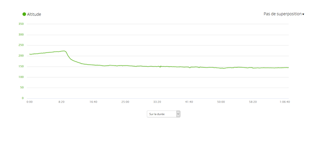
    I still have the same issue (this has been so for months) of losing ~40m during my activity: elevation is almost correct at the beginning of my runs (within GPS accuracy) and at the end, coming back to the same place, it is 40m less...

    Note that when displaying GPS elevation, it shows the correct elevation at the end, so I was hoping that auto-calibration during the activity could fix this issue.

  • Note that when displaying GPS elevation, it shows the correct elevation at the end, so I was hoping that auto-calibration during the activity could fix this issue.

    The question is whether you really use the DEM auto-calibration, or just the GPS auto-claibration. The accuracy of GPS acquired elevation is very limited (in the order of tens of meters), so it would not help as much as the DEM calibration. The DEM calibration still depends on proper lat/lng GPS positioning, but the accuracy there is an order better than at the elevation. And together with little accidented terrain, as a result, the DEM accuracy can be even more accurate.

  • I see exactly what you describe.  An empty elevation plot in the activity history after loading 6.52.

    From version 6.51:

  • Do not forget to report it to Garmin. It is unsure how closely they monitor this thread. This is from the Beta Download page:

    For any issues that you encounter, please send an email to [email protected]. In your email please include the software version, and a detailed description of your issue, along with any steps to reproduce. Please note that you may not get a response to the email unless we need more information on the issue you report.

  • Already have.  Just wanted to let @dav.dc know he's not alone Slight smile

  • Same sort of thing with a Walk activity for me:

    Walk yesterday (on version 6.51) - plot like D_Estes shows;

    Walk today (after update to V6.52) - No plot at all, Just a ! in the circle sub-screen and a statement across the main screen "No Course Elevation Data".

    The same activity uploaded to Garmin Connect does show the Elevation data on a plot.

  • The question is whether you really use the DEM auto-calibration, or just the GPS auto-claibration.

    The question is rather what do Garmin mean by "auto-calibration during an activity" ?

    Below you can see the elevation profile (Garmin Connect screenshot) of a run I did today. I did a loop on (almost) flat ground but I get +10m on the first 2km and then -70m. The true elevation is around 220m and at the beginning I have 215m which is taken from auto GPS calibration (I don't use DEM). During the whole run my GPS elevation is in the range of 210m-230m so not perfectly correct but really acceptable considering the accuracy we can expect from it.

    I understand that data taken from the barometer are tricky to convert into elevation (for example beacause of temperature changes as I go outside), and so I think recalibrating (using GPS or DEM) during the activity is  really a good idea. But so far this new feature did not bring any change to this behaviour I have been observing for several months.

  • which is taken from auto GPS calibration (I don't use DEM)

    As already written, the accuracy of GPS elevation is in the order of tens of meters, unlike at DEM under typical conditions, so I would rather suggest using the DEM. Not telling it will fix the problem, but you exclude one layer of incertitude.

  • As already written, the accuracy of GPS elevation is in the order of tens of meters,

    Yes I saw what you wrote. And as I already wrote my GPS elevation was always between 210m and 230m. So as my run ended below 150m it clearly did not recalibrate except at the very beginning.