Elevation problem

Former Member
Former Member

HI

I did read a lot of discussion here:

elevation-consistently-inaccurate-reading-too-low

problem-with-barometric-altimeter

altimeter-issues-in-the-rain

Looks that I am not alone who has problems with elevation. Problem which happen in my case is ONLY during activity. I also think that there are several different problems.

#1

I did check pressure and elevation graph in watch during the day (holding ABC and scroll), values were OK. I did compare pressure with my weatherstation and very close national weatherstation. I did stay at home during all day so altitude was same but elevation in watch change a little (+-5m).

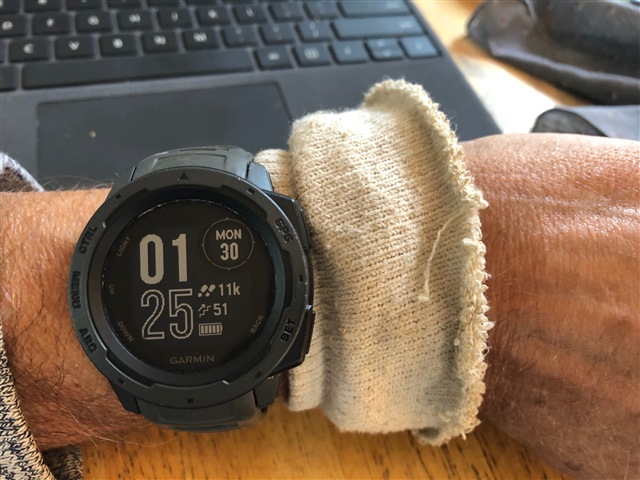
I did start mtb ride at 5:30pm and for 1h ride I did make cca 17km. I did make several small up and down hills. Before I did stop activity I did see that elevation is not correct because I did start and stop almost at same place.

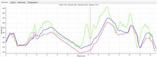
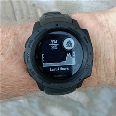
Here are graphs just after I came home:

you can see that elevation at the end is higher. I did start at 228m and stop at 264m.

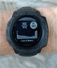
pressure graph, I was SHOCKED, how pressure can change so much, cca from 1016 to 1022. I did find out that it happen during descent.

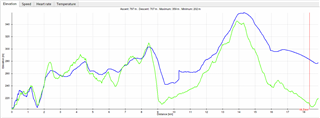
I did check my local weather station:

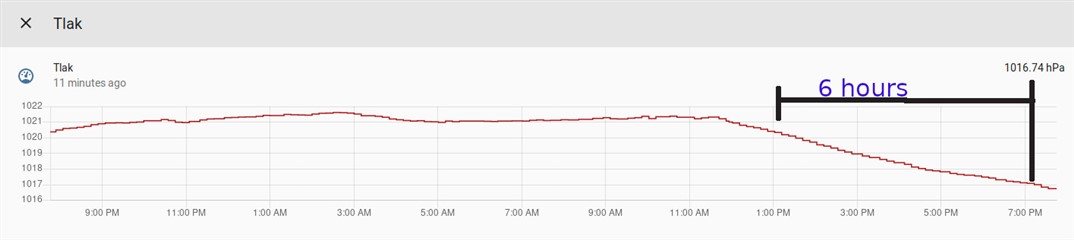
I also check national weather station, and there is also nothing strange. I did put marks to be able compare with watch 6 hours graph. I think, there is something wrong with sensor or with firmware of Instinct.

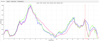
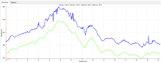
I did export activity to GPX and then enable elevation correction in web and export that too. Here is comparison

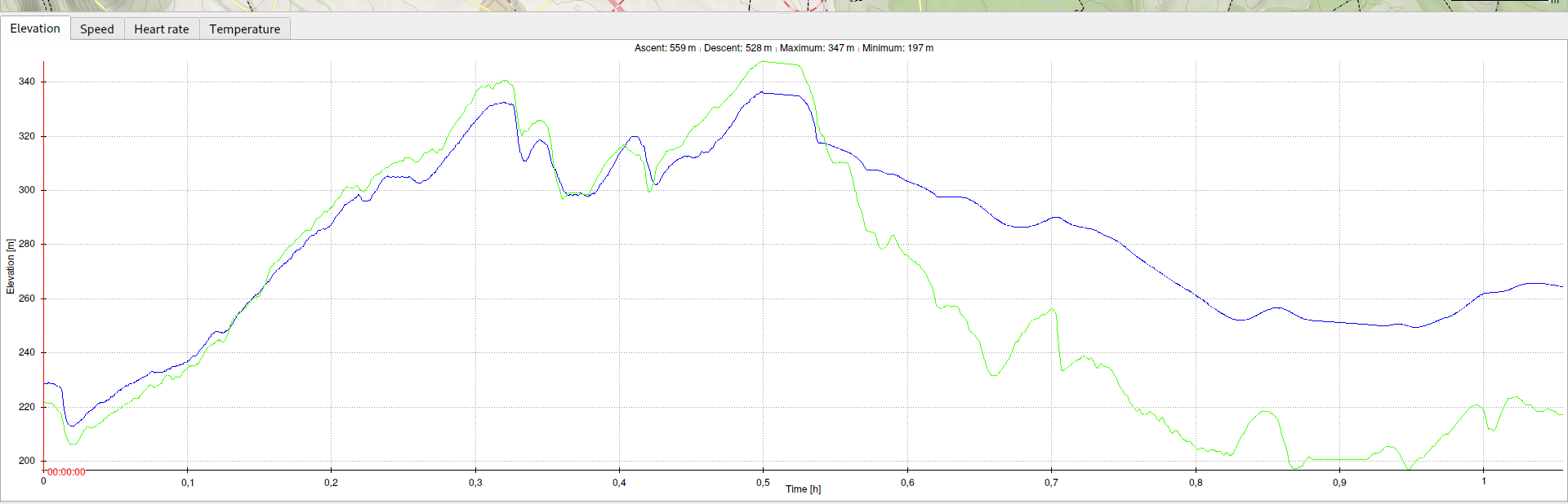
Blue is original GPX with elevation based on barometer. Green is GPX which has elevation correction enabled.

The significant change start at cca 0.55h = 33min of ride during normal descent.

In other threads someone mentioned sweat can make some problem. And there is also thread where rain is mentioned. Do you think that this can be problem in my case? It is 4 hours after I finish my activity now. Watch still showing wrong values of pressure and elevation. If it is problem of sweat or water then how long it takes to dry? or is it going to correct itself?

#2

What I also know is that instinct is slow in elevation reading.

I can see that in fast descent. Another day I went slower on downhill and also slow down before next uphill. Results was quite OK. Of course, barometric altimeter will not catch all small hills.

Settings:

- altimeter auto cal = off

- barometer watch mode = auto , Tell the true, I don't understand this settings clearly.

thanks for any comments

  • Former Member
    0 Former Member over 4 years ago

    UPDATE #9

    I did make 3 ride from last update. Before each ride

    a) I did switch watch mode to altimeter. (during day I did use barometer mode).

    b) calibrate barometer, first I did enter correct altitude and then sea level pressure which I did get from national weather station (it is cca 10km away from ym home)

    c) leave watch on bike in open garage so it is outside for cca 10 to 15 minutes, then put watch on wrist prepare bike, then check if altitude is correct and start ride, usually I start activity when I am away from home.

    First ride is same as my previous ride. Results are bad. GREEN is coming from elevation correction from garmin web connect. BLUE is original using watch mode = altimeter. And RED is using watch mode = auto.

    Second ride is also same with my previous ride. Results are much better BUT from 15.4 km distance it start to drift, I think that if I will continue result will worse. Again GREEN is coming from elevation correction from garmin web connect. BLUE is original using watch mode = altimeter. And RED is using watch mode = auto.

    Third ride is single. Results are again bad. GREEN is coming from elevation correction from garmin web connect. BLUE is original using watch mode = altimeter. There is strange change at arrount 10.3km

  • Former Member
    0 Former Member over 4 years ago in reply to Former Member

    I wouldn't put to much stock in the elevation correction feature.  The information you get from these surveys are not spot on.  What happens is a map is broken down in 10 meter squares (grids) and assigned an elevation for that grid based on the average elevation within that grid.  Depending on the slope of the grid you're in, your actual elevation may be much higher/lower than what elevation correction is telling you.  Another issue is Garmin states their GPS will be within 15 meters of your actual location  95% of the time.  If your GPS is 15 meters off, when you use elevation correction, you may be getting the data from a grid you weren't even in. The barometric altimeter will drift and be off for any of several reasons we've already discussed.  What's important though even if the total elevation is off by 100 feet is the barometric altimeter will still be more precise measuring elevation gain/loss then surveys alone.

  • Yes, I've been wondering about the use of Garmin's "corrected elevation" as the benchmark for these comparisons. The "corrected elevation" data could be particularly inflated if you are riding under significant tree cover and/or in steep terrain.  I'm not sure how Gamin's correction works, but I know that Strava will vastly over-estimate elevation gain in some circumstances.  I'm sure they use some smoothing in their correction algorithm to reduce the noise inherent in predicting elevation from a GPS track.  

    I usually compare my Instinct's elevation data (on rides) to what I've seen for years with an Edge cycling computer.  I've noticed that many Edge models (e.g. 500 vs. 510 vs 520 vs 820...) give a variety of ascent results on the same ride. 

    I appreciate Janci's detailed comparisons, as I have also had issues with the Instinct smoothing out climbs.  And I'm sure you can tell which graph better represents your actual ride.  

    I've had pretty acceptable results recently on both runs and rides.  I frequently clean/soak the sensor area, switched to Altimeter Mode during many activities, and wear an absorbent wrist band in front of the watch.  On bike rides, I wonder if this might protect the sensor from some wind disturbances.  

  • Former Member
    0 Former Member over 4 years ago

    Former Member thanks for discussion here.

    yes, I did say that already, I know that GREEN line (elevation correction) is not 100% true. I am not expecting it will match. Lets say that I am expecting 90% of match. Here is table with comparison in total gain and loss.

    You can see that error is quite big in some rides.

    Yes, I know the terrain so check ride 130, it is first ride from UPDATE 9 comment.There is a hill at cca 9.8km The track is going downhill to altitude 240m. Then it is continue uphill. As you can see Insinct keeps lowering altitude while I am on uphill. Same situation is happen at cca 12.7km, while I am on uphill instinct is still showing lower and lower altitude. In other words, I am going up and instinct down.

    I know that instinct can do that better, check ride 122 or 124 or 125 (if you read my comment about 125 you will find that I am explaining accuracy of green line) or Ride  131 which is second ride in UPDATE 9.

    yes, I did upload those ride to STRAVA, and thats showing different elevation gain. I think that they doing elevation correction for each activity doesnt matter what device recorded. Reason can be "we want compare"  different activities from different devices.

    Before I did buy instinct I did used phone with Locus Map app to track my ride. I did upload that into garmin connect. BLUE line is original and GREEN is elevation correction. I dont know why it is shifted, but it is constant in time. Problem of blue line is noise. On that ride I did get big elevation gain and loss. What elevation correction in garmin connect and in strave do is calculating new elevation from position on map. It is not 100% but it is much much better that elevation from GPS. If barometric altimeter is not closer to "elevation correction" then there is no reason to buy such device.

  • There's isn't a lot of mention of the barometric pressure. Surely this is partially independent of the altimeter, where the altimeter is corrected by GPS. My altimeter seems to show a slightly high reading (suggesting a lower altitude) whilst a stationary reading of the altimeter, without GPS, reads high. It also reads high with a GPS point fix. 

  • Former Member
    0 Former Member over 4 years ago

    So I did call garmin support in my country today. I did also send them description of the problem. I did ask them if I can send watch for RMA. Answer is saying:

    1) If you want to measure altitude exactly, you need to buy a device that is used by the skydivers and is calibrated.

    2) I definitely recommend to turn on 3D speed and 3d distance.

    He also mentioned in phone call that I can send watch, they will check them and probably they will work OK so they will send it back.

  • Do you have your Instinct set to smart recording or every second recording.  https://support.garmin.com/en-US/?faq=xQvHXbfaT27Zr4hxZDvjv5  Wondering if that would help.

  • It appears that you had better results with your gadget.  Have you tried both the gadget and Altimeter Mode on the same ride?

    While it is nice that you can "correct elevation" after completion on tracks where there is an issue, I think it is important for the ascent function to work during the activity, particularly on longer hikes/runs/rides with a significant amount of climbing.

    Here is my low-tech, inelegant solution... that actually works pretty well.

  • Former Member
    0 Former Member over 4 years ago in reply to 3464891
    Do you have your Instinct set to smart recording or every second recording.

    I am using every second recording. I did read that page and there is nothing about altimeter accuracy.

  • Former Member
    0 Former Member over 4 years ago in reply to GeoffR

    No, I did not used gadget with watch mode = altimeter. At this moment I am trying to show to garming support that something is not good.

    yes, it is important that watch will show good elevation values durring activity, not at home. It is MORE important that watch will be very precisely during short activity then during long time activity. You can see on my rides, for example: Going downhill, from example from 300m above sea to the valley which is 240m above see. At valley watch showing 260m, we could say, OK. But from valley I am going uphill and watch is showing 250m and later 240m. CAN WE ACCEPT THAT?