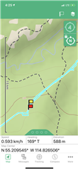
Hey guys looking at Garmin earth mate app... what are the dash lines representing on the maps? I have been to many of them... atv right past and nothing there, no trail, no cut line, no road, no creek, nothing. Any clues?

Hey guys looking at Garmin earth mate app... what are the dash lines representing on the maps? I have been to many of them... atv right past and nothing there, no trail, no cut line, no road, no creek, nothing. Any clues?

I believe these are supposed to be trails. (Streams are blue and thinner dashes, I think.) However, the legacy Earthmate app uses the old DeLorme map products. These may well be outdated. In addition, there is no distinction between foot trails and jeep trails. So these might well be narrow foot trails that might be overgrown, covered with leaves, or whatever - making them hard to see.
Thanks for the reply!