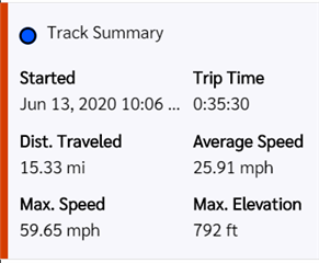
InReach Mini reads out approximate distance from start of day. How can I get that readout on MapShare?

I can see when a track starts on MapShare.  My question is - I want to know the distance from the tracking start to the current location or on any of the track points.  I know that it won't be accurate due to the interval and straight line tracking.  But, the InReach mini device shows the user the approximated distance.  How can I get that reading while viewing MapShare tracks?  Thank you.

  • I don't know of any way to do that. Unlike the Map page on your explore.garmin.com account., the MapShare page does not offer the measure tool.

  • Hello:may I suggest you to export that track in gpx format and read it on Mapsource or Basecamp. If you need more information please let me know it.Martin

  • Thanks for suggestion.  Here's my situation.  When I use my InReach Mini - it always shows distance covered and average MPH.  I know the distance is an approximation and I'm fine with it.  Now, I'm watching the tracks unfold of another InReach Mini user - real time.  I simply wondered if I couldn't have his Distance revealed on the track point.  That's it.  Downloading, converting etc isn't the objective.  I'm just looking for a quick approximate readout and the one contained in the device is perfect.  Nice if that was part of the track summary data.

  • I understand you perfectly . However I must say that Mini doesn't seem to be a reliable device for tracking. In fact I use a 64sx to track and the Mini only for messaging. But keep in mind that the Mini own track is not visible for the mini . So I don't think that measure it from the Mini will be possible

    However , (if it helps you)I will check the explorer site to try a solution for you. Just give me a day and I will let you know. TKS Martin

  • It is part of the track summary data, even on MapShare. However, I am not sure it is populated while the track is in progress. It is certainly there after the track terminates. I know that "after the track terminates" does not help your use case.

    You can, perhaps, get a rough estimate using the map scale displayed in the lower left corner of the MapShare map. But it's going to be a very rough estimate.

  • Hello again : I can confirm that explore site has a measuring tools that can be selected and used over a track (previously imported) and it measures perfectly . I imported a track that i took with my 64sx and the measure tool gave me the exact distance . Inreach Mini will never do that because it is not visible by the unit . I hope that it helps you . Goodbye Martin