Converting GPS to distance

Similar issues to those outline exceptin other threads but my issue is for OW swimming. I've read all the advice on improving GPS tracking but I'm not sure tracking is the issue so much rather more a software issue.

I swam last night with it on my wrist (a new fenix 5s - recently replaced a fenix 5s that does on me that had no tracking or distance issues at all). At the same time a palSwamwith his vivoactive 3 in his tow float. I went slightly further than him but no more than about 200ms. 

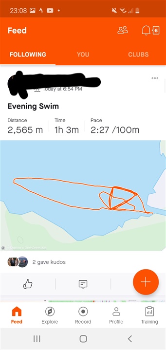
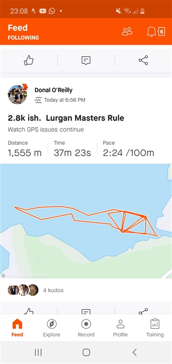
His distance is pretty accurate whilst mine is about a Km shorter. Comparing our traces in the map there isn't much difference, except mine is full of perfectly straight lines where I'm guessing the GPS is joining the dots between where I was and where I've been. But that doesn't explain why the distance would be so out of whack. If the GPS can estimate my route pretty accurately why is it getting the distances so badly wrong? Is it not adding on the "guessed" sections of my swim where I lost signal to my overall distance? It's missed practically half of my swim. 

My old fenix 5s seemed far more accurate and my swimming style hasn't changed in that time. It hasn't to be a software thing otherwise how could our maps on connect and strava look so similar but the distances look so different? 

Definitely not what you'd expect from a premium watch nor does it explain why one fenix 5s would work well but another so badly. 

You'll see both my route and my friends route below. How similar the paths are, bar me swimming further out to the point, making the 1km difference in total distance so perplexing. 
  • For swimming does Strava support the "Correct Distance" function that it does for Running? On the website for strava, right underneath the distance. It recalculates the distance based on the GPS points. You can revert it if you don't like the distance value.

  • Nice one. 

    It is certainly closer to the truth but still ends up half a kilometre short. I think that when Garmin joined the dots between where I lost and picked up signal it has my moving time in and around 8 mins... So my average pace is 28s per 100m which is now way fast. 

    You know the fenix 5 with its gyroscope is supposed to find the satellites faster and be more accurate. Very disappointing really that it takes a Strava work around to try and mitigate for garmins problems. 

  • At least for running I'm sure that the watch is filtering/averaging the points and somehow using the accelerometer when calculating the distance. Even before watches had accelerometers there would be some difference between the watch distance and the "connect the dots" distance. When using the Strava recalc it just looks at the saved gps points, so if the distance is short now it's because the watch just missed saving some gps points that contributed to the distance. I do think it would remove a lot of frustration on this board and others if they were more forthcoming about how each of the modes worked

  • For running and hiking, the distance is always calculated from the satellite-signal. In a fit or gpx file are the measured position (longitude, latitude and elevation). From those information the watch calculated the single distance from position to position. The total distance is the sum ofcall single distance

  • It seems that the GPS signal has been lost sometimes. If no position point is available the course shows long straight lines and the calculated distance is inaccurate. Furthermore if the GPS quality is poor due to a limited number of satellites, the SW calculates dead reckoning.

    en.wikipedia.org/.../Dead_reckoning

    Even the starting point of the first pic isn't correct. Have you download the Almanach and waited for the fix of the satellietes (green ring)?

  • Yeah, I usually sync to phone, load up the swim activity profile, wait for the GPS to be found (green ring) and then walk to the water. 

    I don't know what the "Almanach" is to know if I have it or not but I will look into it.  

    D

  • I don't know what the "Almanach" is to know if I have it or not but I will look into it.  

    You can see this directly at the watch with

    Menu > Settings > About > EPO 

    Extended Prediction Orbit (EPO) files may be current or expired

    https://support.garmin.com/en-CA/?faq=6IbaJEHc1i9gydzQomXzyA

  • Thanks for your reply. I don't think it's true though that the watch uses the calculated distance from position to position only. My evidence of this is because adding up the distance between the positions from the file would be the same distance as the watch shows and it is not.  Alternatively, the watch could be adding up the positions and then the positions saved tot he file are filtered (some averaging) but considering how wavy the tracks are from GPS watches these days it seems less likely.  I don't really know what is going on in the watch, just trying to guess based on the observation that the added up distances of the points in the file doesn't match match what the watch calculates. 

       As another observation, you can go through a TCX file and see where the GPS drops out (no lat or long written for that second) but the distance is still incremented from the watch accelerometer I assume like the treadmill or ultranav modes which are accelerometer-only for distance accumulation.

       Strava can do the gps point recalculation or various websites such as this one, https://geo.javawa.nl/trackanalyse/index.php?lang=en.