Fenix 5: navigating to a destination (elevation chart problem)

I have a fenix 5 for about 1 year and it is mostly working fine. They other day I was playing with it and
using the navigation to a destination feature and in particular I was looking at the elevation chart.
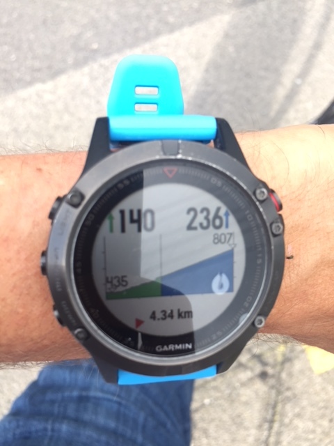
When I start, all is working as expected; the elevation of my final destination is at 680m (first picture)
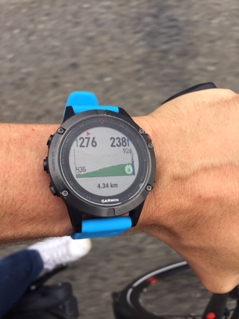
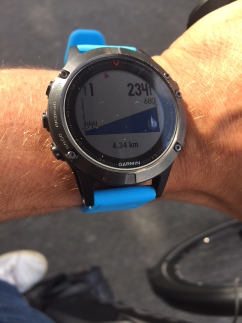
Then I start to go up and I see that the elevation of my destination is also rising gradually from 680m to 807m and
then finally, close to the arrival to 926m (picture 2 and 3).
It makes absolutely no sense that the elevation of my destination is rising so that I am basically never reaching it.

When saving the activity, the elevation is absolutely correct so the altimeter seems to be working correctly.
I have also been doing a factory reset of the watch and deleted all external widget/watchfaces/app that could
create an error. Am I doing something wrong in the setting of the watch or is there a bug?

Any help would be much appreciated.

Simon
ciq.forums.garmin.com/.../1360001.jpg ciq.forums.garmin.com/.../1360002.jpg ciq.forums.garmin.com/.../1360003.jpg
  • I have the exact same problem, something is def wrong with the elevation chart
  • Hi there, thanks for your answers. I have actually send my watch back to Garmin support center and they have sent me a new one.
    The problem is not solved though. I still have exactly the same problem. This is quite frustrating because this feature would be quite useful
    for mountaineering actually.
    Is there anyone around here who has a working elevation chart when using the navigation function?

  • Former Member
    0 Former Member over 7 years ago
    I have same issue on my fenix 3hr. I was in contact with betateam. They tried to fix this. but they didn't find how to fix the problem.
    This is not a problem on fenix 5x

    best regards
    Stig Erik
  • Thanks for your answer Erik,

    well I have to say the more I use the Fenix 5, the more I am disappointed. They really market the Fenix 5 towards outdoor activities and then you see that
    features such as Utratrac ( a huge disappointment in terms of accuracy of the position, each point is oscillating ~500m away from the path although they market is as a GPS with less frequent positioning without loss of accuracy.), and elevation towards a destination just dont work. This should be basic features for hiking/mountaineering.
    Moreover they dont' even offer a proper ski mountaineering mode although there are plenty of marketing pictures letting us think that it is targeted to those people.
    Of course, you can find tweeks and configure it yourself and bypass these problem but basically
    they just don't offer what they promise in the marketing of the watch.

    Not the best way to keep customers in my opinion. On the other hand, the support center just exchange my 1 year old watch for a new one.
    That is great but still doesn't work 100% properly

    Simon
  • Just to know, are there other people out there that have tested this feature and where it works.
    This elevation chart could be very useful should it work well.

    ciq.forums.garmin.com/.../1368126.jpg
  • I am trying to replicate this issue, so I added the Elevation field to my Navigate activity.
    It seems to show the elevation log, not the elevation that's in front of me on my course.
    But maybe that is the way it's supposed to be?
  • Hi VHenk,
    thanks for your answer. Well I am not sure of what your watch is really showing when you go to Navigation / saved locations and then look at the elevation chart.
    In my opinion, it should show a straight line between your starting point and the saved location you want to reach as well as the elevation difference that is remaining.
    As you start to go towards your saved location, the elevation log should start to show and the elevation difference should start to decrease. Of course, the elevation of
    your saved location should not change (and that is the problem in my case). Is it more or less what you are seeing?

    Thanks for your help.

    Simon
  • Hi Simon,

    I was in the Austrian Alps when I wrote that.
    Being back in the flat Netherlands it is impossible to check this function as we have absolutely no elevation over here.

    However, it would begreat if it was possible to navigate a (previous or created) route where the fenix would show an elevetion profile and how far you would have advanced over that mountain profile.
    Is this what you think the elevation chart should show? That would make me extremely happy.

    Henk
  • It looks like the new Fenix-5 Plus has this feature. It is called ClimbPro.