What map do you use? I use its own maps and used OpenStreetMap maps from opentopomap.org and garmin.openstreetmap.nl with no map drawing issues. In past firmwares I experienced such drawing issues but newer ones don't have a problem.
Maps may have some wrong data or other rendering issues at some places, but if it doesn't do the same thing at the same place it may be a system issue. I just disable all the maps, and just enable the one I use, so that processor won't access all maps and render more data at once. Just for POIs, sometime enable the default map too.
It's still there for me also. Thought it was solved on my trail run yesterday, but after more than an hour or so it frose. It's been discussed in older threads. I use OSM maps.
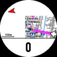
I've been meaning to post the same thing! Had it a few times with 5.10, not used 5.30 enough yet to see it. Seems to occur randomly, and the map doesn't get drawn along with the course lines. The little cyan triangle, scale, and bottom data field (normally showing distance left) are still visible. Switching to a different screen and back fixes it, but it may occur again some time later (not immediately you move off the current display though).
The issue occurs while using a free osm topo map. I am using this map since month. With an earlier fw this issue occurred, too. That was fixed with a fw update and now it remains....
Have also installed some garmin maps (topo Germany v7/ cn nt Germany). Will have a look, if these maps are affected by this issue, too. To change the data screen and went back to the map page didn't solve the prob for me.
Haven't tried with 5.30 but had it with previous software version. An other issue with map rendering is an error when you try to see a map of a course before starting the course - there are only horizontal lines. I mailed it to beta team some time ago.
The horizontal lines depends on how you create the fit file. I know that if I create a course in GPSies and convert tcx2fit with the McBadger-tool Iget that result. I've also talked to the beta team.about that. If I link the same GPSies course in routeCourse and transfer to watch or if I convert tcx with FitFileRepairTool, I don't get the horizontal lines.
The horizontal lines depends on how you create the fit file. I know that if I create a course in GPSies and convert tcx2fit with the McBadger-tool Iget that result. I've also talked to the beta team.about that. If I link the same GPSies course in routeCourse and transfer to watch or if I convert tcx with FitFileRepairTool, I don't get the horizontal lines.
My observation: problem solved from the version 4.21 Beta
EDIT: Upss. For courses prepared in TCX2FITRC1 bug still is appearing.
Well, that's puzzling. There isn't anything particularly weird about how my fit files are created. Would you mind sharing the course fit files with me, so I can look into this? Do the other methods give you turn-by-turn warnings?
I should note that the Garmin course creator has switched from putting all the coursepoints (turn markers) at the end of the file to interspersing them with the trackpoints defining the course, and I haven't yet updated my software to do this, and I've had reports from F5 users that this causes odd behaviour when you join a course anywhere but the end, because the watch doesn't give the turn alerts.


