Increase thickness of lines on map?

Former Member
Former Member
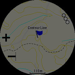
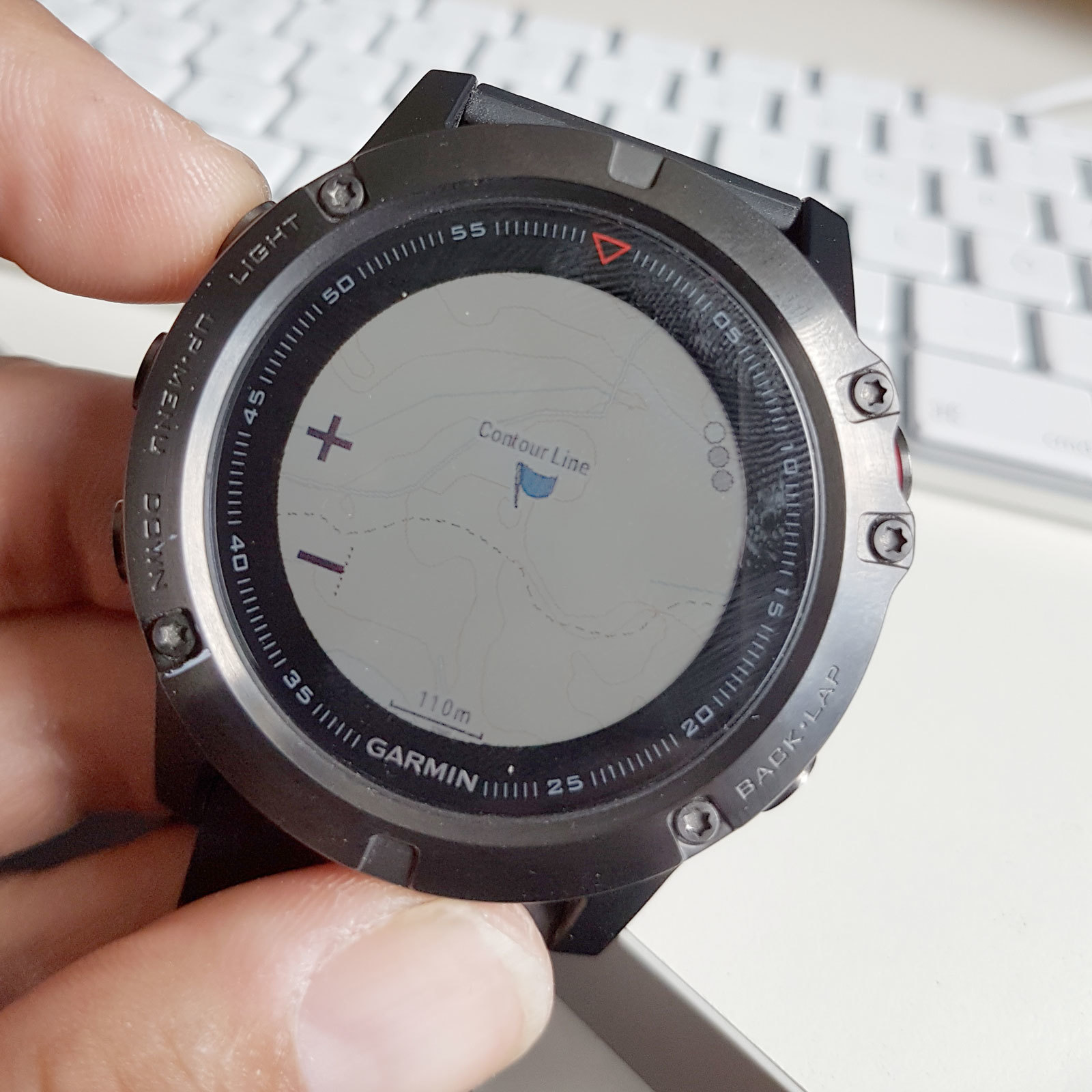
Is there any way to increase the thickness of the lines of the maps? In my case, I purchased the TOPO Sweden Pro map from Garmin (appr. 170 ?) ? but it is barely usable when out and about. I attach a screenshot, which I slightly adjusted in PhotoShop in order to be truer to what you actually can see on the watch. The one thing that is clearly visible in the screenshot is the dashed line (a footpath). But just under the C of "Contour Line" a much larger, paved road passes, which is barely visible on the map. When out and about and subject to reflections, it is basically impossible to separate contour lines from paths, area outlines etc.

So. Are all of the strokes defined within the map itself ? or are there any parameters that could be tweaked on the watch in order to force the unit to draw certain lines bolder or in more distinguishable colours? ciq.forums.garmin.com/.../1237512.jpg
  • Former Member
    0 Former Member over 8 years ago
    BTW: here is, how it looks when not using a screenshot but taking a photo. Even worse than what I accomplished in PhotoShop...
    ciq.forums.garmin.com/.../1237531.jpg
  • Former Member
    0 Former Member over 8 years ago
    Being honest, the maps that Garmin are ok for most people but people like hikers etc etc will struggle with the contours and to get details. I have a Video on my YouTube channel that shows you how to install third maps that improve things. You will see from the image below that the lines, paths and contours are more visible.

    If you want to use the video, its here

    https://youtu.be/0V_04TnzXaU


    Full disclaimer its my videociq.forums.garmin.com/.../1237582.jpg
  • Yes it is probably possible. I'm no expert, but I've after reading a lot of posts here done my own map formatting that is useful for me and others over the age of 45 with a 5x.
    I've done it on OpenStreetMaps in Garmin img format, so probably it also work on a bought map.
    In short it is to change the TYP file thats inside the IMG file. Either you export your TYP, change it and import again or take one that someone else has done and import it over the one that you have.
  • Former Member
    0 Former Member over 8 years ago
    You could always try the talky toaster maps. The details are excellent and very clear.

  • Former Member
    0 Former Member over 8 years ago
    ...I have a Video on my YouTube channel that shows you how to install third maps that improve things. You will see from the image below that the lines, paths and contours are more visible...


    Thanks. Actually, I watched all of your 5x-videos while deciding whether to invest in the watch. Thanks for putting those online!
    I do know that different maps have different lines, paths etc. The included TopoActive-map is much more readable, for instance. However, in my corner of the world (rural Sweden), all OpenStreetMap-based maps are amazingly sub-par, lacking even many rather large roads. The only thing they are usable for are basically contour lines. The only maps that really work for hiking are the ones licensed by the National Survey/Cadestral Authority :(
    So I was looking for a solution to copy the display settings from one map over to a different map, to give me a map that both contains all relevant data and that even is readable :D

    ...In short it is to change the TYP file thats inside the IMG file...

    Thanks for the pointer. Will have to look into that. Not sure whether Garmin's paid maps will "survive" such changes, though. They most certainly use checksums to determine whether the maps have been tampered with/pirated.
  • Check the comparison maps here: https://mc.bbbike.org/mc/?lon=13.3885000000002&lat=52.51740221046066&zoom=10&profile=extract&source=extract

    Then go here: http://extract.bbbike.org/ and make yourself a map. There is a limited selection in what can be exported for Garmin in comparison to the full map list in the comparison tool, but it's still quite good. Full 40m contour maps towards the bottom of the list.
  • Former Member
    0 Former Member over 8 years ago
    I really do appreciate all your helpful tips about osm-based maps, but they simply are not usable in my area. Up here, it is too sparsely populated for community-created maps to work reliably. Even Google et.al. don't bother for roads that cannot (at least theoretically) used by vehicle.
    I attached a comparison of an area not too far from where I live. None of the different online mapping sources come even close to reality. In the bottom right corner, I pasted in the material from the "official" map, which is the same source that is used in Garmin's Topo Pro maps.
    So, at least in the area where I live, the official Maps are (afaik) the only ones that can be reliably used for hiking.ciq.forums.garmin.com/.../1238113.jpg
  • I watched a video laat night about loading the birdseye map overlay onto 5x.
    You need a pc plus basemap plus ?20/year subscription.
    They give satellite images overlayed on your choice of map location.
    I'll try and link here but on my mobile right now.
  • Former Member
    0 Former Member over 8 years ago
    I watched a video laat night about loading the birdseye map overlay onto 5x.


    Thanks! But even sat imagery doesn't really work over here (other than being able to see major roads, lakes, rivers and the like). Everything else, notably hiking trails, are just "woods" ;)
    Once again, the Topo Pro-map that I purchased contains all the needed information and is very accurate. Just barely readable on the watch. I need a way to increase the readability on that particular map.