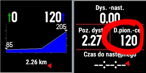
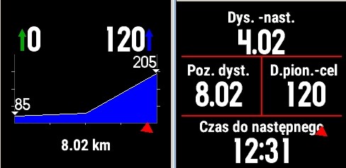
For MTB I'm missing the data field "Vertical distance to next waypoint". There is only vertical distance to destination available. Does anybody know if there is a 3rd party data field available with this informaton?
According to the beta team when a route has coursepoints "vertical distance to destination" shows vertical distance to next coursepoint...
Here is a quote from my mail
Me: MISSING FEATURE: auto valleys / summits when navigating: my 10 year old gpsmap62s has this and it's the only reason I still keep the device. When uploading a GPX with route it automatically calculates summits and valleys out of gpv elevation and shows distance / evelation to next.
Beta folks: There is a V Dist to Dest (Vertical Distance to Destination) option that you can add as a data field to give you additional information in the 3rd dimension with regards to your selected destination. If your routes include shaping points, you might get V Dist to Dest data for each point and not just the final destination. We will test this out as well.
In other thread someone mentioned that in order for course points to work properly course should be at least 2km long (or so). I didn't have time to test that. Interestingly according to beta team coursepoints (called by them shaping points) shoud work just like the mcbadger workaround. This is something I haven't tested as well.
me: MISSING FEATURE: Working coursepoints - there is no way to add working coursepoints / waypoints for a route (prepared in basecamp), so that the watch can show distance to next waypoint while navigating.
Beta: When creating a route in BaseCamp, either make sure that the route points include your waypoints, or turn via points (won’t alert) into Shaping Points (will alert).
I never said it works - I just pasted what garmin team wrote... I would continue my discussion with them on mail but currently have to deal with real life problems and that's on hold. Anyway - they seem to be responsive so if anyone wishes to let them know, they are wrong please do so. I'd love to have this feature working as well.
TCX supports altitude fields in course points. The FIT format, astoundingly, doesn't. Time, position, distance and some metadata. It would be very hard for a third-party field to work out the altitude; probably easier if you were using an app which completely re-implemented courses, but why would you want to do that on a 5x? Should be more straightforward for the watch's internal implementation to do it - it's looking at coursepoints in the context of the whole course anyway and could extract the altitude from the closest trackpoint. It would be much easier if the file format allowed the elevation to be included.
On the F3 at about SW version 4 ?? More or less they dumped in a kitchen sink multitude of GPS functionality that lacked the correct functionality that a 99 dollar GPS 72 handheld does correctly and I have had and open case for two years which would seem to mean there never going to work
For example for the VMG field to function correctly you need to raise your arm and point 12 in the direction of travel and the Felix is the only GPS unit that works like this and the issue also affects the nav bug and realated features