

Not sure if thread title is proper :) English is not my native language.
I think the Save Location feature is to save the current location. Is it possible to input a GPS coordinate to navigate?
Thanks..

Like that ad used to say, there's an app for that, https://apps.garmin.com/en-GB/apps/93712e86-cec9-48c3-b18e-2a87aefead91
Not sure if thread title is proper :) English is not my native language.
I think the Save Location feature is to save the current location. Is it possible to input a GPS coordinate to navigate?
Thanks..
<gpx version='1.0'>

        <name>Cooper River Trail</name>

	<!--  www.wta.org/.../cooper-river -->


        <wpt lat='47.409284' lon='-121.106459'>

            <ele>0</ele>

            <name>Cooperpo TH</name>

        </wpt>


        <wpt lat='47.424152' lon='-121.169501'>

            <ele>0</ele>

            <name>OWHI Camp</name>

        </wpt>


        <wpt lat='47.425546' lon='-121.173321'>

            <ele>694</ele>

            <name>Boat Ramp</name>

        </wpt>


        <wpt lat='47.428420' lon='-121.175595'>

            <ele>0</ele>

            <name>End trail</name>

        </wpt>


    </gpx>
Make a GPX file with your points, attach the watch to your computer with the USB cable, copy your GPX file to the \NEWFILES hidden folder on the watch. When you disconnect, the watch will read the file and save the points.
Here's a sample GPX file:
<gpx version='1.0'>

        <name>Cooper River Trail</name>

	<!--  www.wta.org/.../cooper-river -->


        <wpt lat='47.409284' lon='-121.106459'>

            <ele>0</ele>

            <name>Cooperpo TH</name>

        </wpt>


        <wpt lat='47.424152' lon='-121.169501'>

            <ele>0</ele>

            <name>OWHI Camp</name>

        </wpt>


        <wpt lat='47.425546' lon='-121.173321'>

            <ele>694</ele>

            <name>Boat Ramp</name>

        </wpt>


        <wpt lat='47.428420' lon='-121.175595'>

            <ele>0</ele>

            <name>End trail</name>

        </wpt>


    </gpx>
Note that the elevation is in meters, and can be zero if you don't know the actual value.
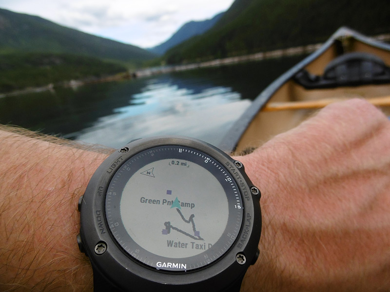
This is roughly how they'll be displayed. This is a Fenix 3 HR not a 5, so there may be some changes but they should be minor.
I've done this many, many, many times, it always works. I haven't found an easier way.
When I don't have the coordinates already, I use gmap4 to look them up. In the lower-right corner are the lat/lon values for the center of the page, which has a cross-hair. This also lets you change base maps, some of them have detailed trails, others have terrain, etc.
If you open the Navigation App (or any other activity app that uses GPS) then go Menu>Navigation>Coordinates you get a screen to enter the coordinates in to. Once you've done this, if you back out of actually navigating to those coordinates and go to Menu>Navigation>Saved Locations you'll note a saved location called 'Coordinates' that you can select and re-name to something more convenient (and update the coordinates or elevation should you choose).
Make a GPX file with your points, attach the watch to your computer with the USB cable, copy your GPX file to the \NEWFILES hidden folder on the watch. When you disconnect, the watch will read the file and save the points.
Here's a sample GPX file:
<gpx version='1.0'>

        <name>Cooper River Trail</name>

	<!--  www.wta.org/.../cooper-river -->


        <wpt lat='47.409284' lon='-121.106459'>

            <ele>0</ele>

            <name>Cooperpo TH</name>

        </wpt>


        <wpt lat='47.424152' lon='-121.169501'>

            <ele>0</ele>

            <name>OWHI Camp</name>

        </wpt>


        <wpt lat='47.425546' lon='-121.173321'>

            <ele>694</ele>

            <name>Boat Ramp</name>

        </wpt>


        <wpt lat='47.428420' lon='-121.175595'>

            <ele>0</ele>

            <name>End trail</name>

        </wpt>


    </gpx>
Note that the elevation is in meters, and can be zero if you don't know the actual value.
This is roughly how they'll be displayed. This is a Fenix 3 HR not a 5, so there may be some changes but they should be minor.
I've done this many, many, many times, it always works. I haven't found an easier way.
When I don't have the coordinates already, I use gmap4 to look them up. In the lower-right corner are the lat/lon values for the center of the page, which has a cross-hair. This also lets you change base maps, some of them have detailed trails, others have terrain, etc.
Do they automatically show up on the map screen if they are "close" enough to be seen? Did you have to navigate a course to see them?
