Lets hear some reviews, comments about the maps feature

Former Member
Former Member
How do you like the presentation of the maps on your screen?
Speed of loading maps?
How often do you see yourself using them?

Anything you would like to share is appreciated.

for me, i am still leaning towards what looks better and I prefer the 5 silver. not fond of the blue-grey strap, but I think it lends itself better to some leather bands, or even orange, black, or even a nice heavy stainless steel band in the future.

I own a Fenix 2 that is non saphire and have one small scratch on it, plus its all black. so why the black or slate grey don't appeal to me as much. Im trying to convince myself that its time to replace the strap for built in.
  • OpenStreetMap looks like it's a road database. You already got that on the watch in the US at least..... and it looks pretty complete and up to date from what I can tell, so I'm not sure why you'd want to replace or augment what's there in that regard.


    Well for me, I sometimes travel internationally for work and it would be really helpful to have maps in those locations. But it doesn't make sense to pay $99 (or whatever Garmin charges) for a map that I might only use for a week. So in those cases it would be great to get OpenStreetMaps for those cities. And for city running, routable street maps (as opposed to topo maps) is exactly what I'd like to be able to install.
  • Former Member
    0 Former Member over 8 years ago
    I found a way to use my non-DEM/shaded 24k topo's and also get working elevation plots on the watch. Side note, I want to use my non-Garmin topos as they have a ton of good additional trail and water locations data, land owner plots, and 20ft contour lines. Anyway, here's what worked for me:

    1) Set my non-Garmin, non-DEM/shaded 24k topo as main map in basecamp and create my route.
    2) Switch to the Garmin 100k Topo map in basecamp
    3) Convert my route to a track
    4) Enabled the Edit->Advanced->Set Selected Track to Map Elevation option
    5) Send track to watch

    I then have my activities set to show my non-Garmin topo for the map. When I load the exported tracks for an activity or to navigate, the elevation plots work great. I would guess this will work for any non-DEM/shaded map. Granted, the elevation plots on the watch will be based on Garmin's 100k Topo map, so the elevation data is likely not as accurate as their paid 24k variants.
  • I found a way to use my non-DEM/shaded 24k topo's and also get working elevation plots on the watch. Side note, I want to use my non-Garmin topos as they have a ton of good additional trail and water locations data, land owner plots, and 20ft contour lines. Anyway, here's what worked for me:

    1) Set my non-Garmin, non-DEM/shaded 24k topo as main map in basecamp and create my route.
    2) Switch to the Garmin 100k Topo map in basecamp
    3) Convert my route to a track
    4) Enabled the Edit->Advanced->Set Selected Track to Map Elevation option
    5) Send track to watch

    I then have my activities set to show my non-Garmin topo for the map. When I load the exported tracks for an activity or to navigate, the elevation plots work great. I would guess this will work for any non-DEM/shaded map. Granted, the elevation plots on the watch will be based on Garmin's 100k Topo map, so the elevation data is likely not as accurate as their paid 24k variants.


    Thanks for this. Right now I'm being a bit greedy: even though I know you can create Routes and Tracks in advance on BaseCamp and then transfer them to the 5X, I also want the flexibility to just transfer a bunch of POIs and then create new routes from A to B, along trails, right on the 5X. I'm making a few assumptions:
    1) That the 5X creates point-to-point routes the same way BaseCamp does: using the vector data on the currently-displayed map
    2) That the 5X shows a route's elevation profile the same way BaseCamp does: using DEM/contours on the currently-displayed map

    I have a free OpenMTBmap with tons of POI detail and all the side trails, but no elevation data. I have a free OSM map from "alternativaslibres" with integrated contours. Right now I create the route with opemMTBmap displayed, then switch the underlying map to alternativaslibres with the same route still displayed, and right click the route. It shows an elevation plot. However, if I edit the waypoints and then recalculate with alternativaslibres still showing, it re-routes away from the missing trails.

    Flipping back and forth between these maps is a bit of a pain. I'm aware that while Basecamp only shows one map at a time, the 5X (like Garmin handheld units) can show multiple maps at once, overlaid with each other. This makes me cross my fingers for a third assumption:
    3) That the 5X can show two maps simultaneously overlaid, create routes on one of them (which one? the first one enabled? the last? both?), but then pick up the elevation data from the other for the purposes of showing an elevation plot/profile for any given route or track

    But maybe this assumption is wrong, based on what you're saying? Can't you have both your detailed 24K non-DEM map and your 100K topo DEM map on the 5X at once, both enabled to display simultaneously? Doesn't any route automatically pick up the DEM from the 100K map for an elevation plot?
  • Former Member
    0 Former Member over 8 years ago
    I just did a quick test with a track I had imported into Basecamp from a run I did last year.

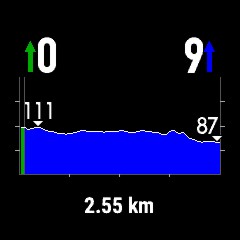
    If I send that track to the watch and chose to navigate it with my navigation map settings configured to show both a non-Garmin 24k topo and the Garmin 100k topo, the elevation plot screen indicates no data to display.

    If I then set navigation to show only the 100k Garmin topo and load that same track I still get no elevation plot data.

    If I go back to basecamp, select that same track, the select the "Set Selected Track to Map Elevation" option and send it to the watch, the elevation plot screen works great regardless of the underlying map being shown for the activity.

    So, in that quick test, it appears the elevation data is being read from the track, not the map being displayed on the watch. And, more specifically, that the track must include the elevation data from a map loaded in basecamp.
  • Former Member
    0 Former Member over 8 years ago
    Yes and no. Other case:

    Course (route) clicked out in the watch. 3 points: Start - > Via - > End

    Navigate -> Courses -> xxx -> Elevation Plot (No Course Elevation Data) :mad:
    App (Routing = Tour Cycling) -> Navigation -> Courses -> xxx -> Do Course (The watch will count the route along roads), Scrolling of screens and ... :o


    DEM from the map.


    If I do that same process with my two tracks, both will show "data", but the one that was not set to map elevation prior to sending to the watch is flat, whereas the course is not. The track that I did check to set the track to map elevation prior to sending to the watch is accurate. The only map active on the watch right now is the 100k topo. Strange.

  • So, in that quick test, it appears the elevation data is being read from the track, not the map being displayed on the watch. And, more specifically, that the track must include the elevation data from a map loaded in basecamp.


    Yes and no. Other case:

    Course (route) clicked out in the watch. 3 points: Start - > Via - > End

    DEM from the map.


    Okay so in summary:
    1. Following a GPS track, as Bombit says, requires that elevation data be embedded in that track.
    2. Following a course/route created on the 5X itself, as GPS_Maniak says, takes the elevation data from the map on the 5X.

    What I don't quite understand is... can't you preload a created *route* onto the F5X from Basecamp without converting it to a track first? Does it then behave like #1 or #2?
    And then there's a further question about whether the F5X pulls from just any map's DEM when multiple maps are displayed/layered, especially when the map containing DEM/contours is different than the map containing routable paths.

    I'll see for myself in 5-6 days :)
  • Former Member
    0 Former Member over 8 years ago
    The Set Track to Map Elevation option in Basecamp does not work for routes. I can move my routes to the F5, but I don't get elevation data on the routes when navigating them on the watch.

    Another thing I just noticed, in that 2nd image I posted above, where the elevation plot of the course looks accurate. It is in that the route has 35xx ft of gain, but is not in that the course actually starts at 9xxx ft elevation and tops out at 12xxx ft elevation. The starting elevation shown by the watch was my present elevation and the peak elevation shown is that elevation + #feet between that and the highest point reached on the course.
  • I did some tests with basecamp/elevation data (all used maps inclouds elevation data):

    1.) created a course with the garmin topo germany v7 pro and sent it to my 5x (elevation plot is shown into basecamp)
    2.) convert the course above into a track and sent it to my 5x (elevation plot is shown into basecamp)

    3.) created a course with the preinstalled 5x map garmin topo active europe west (osm) and sent it to my 5x (elevation plot is shown into basecamp)
    4.) convert the course above into a track and sent it to my 5x (elevation plot is shown into basecamp)

    5.) created a course with the openmtbmap alps (osm) and sent it to my 5x (elevation plot is shown into basecamp)
    6.) convert the course above into a track and sent it to my 5x (elevation plot is not shown into basecamp)
    7.) convert the course above into a track, imported the elevation data from the topo active europe west map and sent it to my 5x (elevation plot is shown into basecamp)

    Only 2.), 4.) and 7.) are showing an elavation plot on the 5x - for courses it didn´t work for me.

    Is it a basecamp and/or a 5x problem or why did via basecamp sent courses not show an elevation plot on the 5x???
  • Just got my 5x yesterday. Does it show maps of trails? I'm wondering i need to download another map for trails for Arizona, Colorado and New Mexico.