Multiple map layers?

In anticipation of my 5X arriving (fingers crossed), I've been playing around with Garmin BaseCamp to prepare routable topo maps (from OSM-derived sources) for a planned April hike in Patagonian Chile. My question is about elevation data / contour lines.

It seems like many of the handheld Garmin GPS units support loading and layering multiple maps, such that you can have satellite imagery, routable road/trail maps, and a "map" of just elevation contour lines, and then turn each of them on/off independently on the device (depending on what you want to see). This seems pretty ideal: I'd probably just look at the trail most of the time, but it would be nice to have the contour data still available, for example, to show the elevation profile mid-route.

Does anyone know if the 5X will support this feature? Did the Garmin Epix? (Without direct user reports, I'm prepared to assume that the 5X starts with the same map/nav featureset as the Epix watches).

I ask because if the 5X can only work with a single map layer, I'm under the impression that I need to "merge" OSM topo maps with contour files in order to create a single blended map. That seems to require playing around with some open source apps and scripts... or paying the (relatively cheap) openMTBmaps subscription to get it done automatically.

Advice?
  • In anticipation of my 5X arriving (fingers crossed), I've been playing around with Garmin BaseCamp to prepare routable topo maps (from OSM-derived sources) for a planned April hike in Patagonian Chile. My question is about elevation data / contour lines.

    It seems like many of the handheld Garmin GPS units support loading and layering multiple maps, such that you can have satellite imagery, routable road/trail maps, and a "map" of just elevation contour lines, and then turn each of them on/off independently on the device (depending on what you want to see). This seems pretty ideal: I'd probably just look at the trail most of the time, but it would be nice to have the contour data still available, for example, to show the elevation profile mid-route.

    Does anyone know if the 5X will support this feature? Did the Garmin Epix? (Without direct user reports, I'm prepared to assume that the 5X starts with the same map/nav featureset as the Epix watches).

    I ask because if the 5X can only work with a single map layer, I'm under the impression that I need to "merge" OSM topo maps with contour files in order to create a single blended map. That seems to require playing around with some open source apps and scripts... or paying the (relatively cheap) openMTBmaps subscription to get it done automatically.

    Advice?


    Im wondering the same thing. But at the same time I would just like to get the OSM onto the 5x and have a route already in their that I did on basecamp. From that route I'd love to have an Elevation profile. (I believe the F3 does this) Also, coming from a Suunto Ambit, I hate how they calculate distance left to waypoint by how the crow flies and not actual distance on the route. I think? but not positive that garmin does it by route. Atleast thats what I'm hoping
  • Former Member
    0 Former Member over 8 years ago
    I'll play around with it tomorrow and see. I've downloaded some OSM maps and I'm going to try them out at the very least.
  • Epix does layers

    I'll play around with it tomorrow and see. I've downloaded some OSM maps and I'm going to try them out at the very least.


    Hey,

    Based on the review posted at http://highlytunedathletes.com.au/blog/garmin-epix-hands-on-review/ , the Garmin Epix does support layers, with this warning: "Map layers uploaded can be turned on or off or combined. The more detail though, the more the maps will lag during panning or zooming, so beware !"


    I can't imagine they would have removed this functionality for the Fenix 5X.

    I guess my question in response to that is: if you have a routeable trail map layer A and an elevation contours layer B, will routes created on layer A display an elevation profile view (using the data that is presumably only contained in layer B)? This would be awesome. It would be even more awesome if it could access that elevation data in layer B whether or not layer B was currently being displayed to generate an elevation profile.

    For me it would be SO CLUTCH to be able to quickly see how far up the hill I am, and how much more climbing I have to do before reaching my destination - but would be nice to not have to lag / clutter up the map display with contour lines.
  • Former Member
    0 Former Member over 8 years ago
    in my opinion F5X is taking DEM (digital elevation model) from the map.

    Film (7.45-9.00): https://www.youtube.com/watch?v=Ii607X1YDs8
  • in my opinion F5X is taking DEM (digital elevation model) from the map.

    Film (7.45-9.00): https://www.youtube.com/watch?v=Ii607X1YDs8


    Yeah that doesn't seem to be in dispute - I don't know where else the elevation profile could come from other than a map. Obviously whichever 100K topo maps come free and preloaded (depending on the country where you buy the 5X)... contain some elevation data.

    My question is about loading free routable OSM maps that may not contain elevation data, as in, outside of the area covered by your preloaded 100K... and whether you can show multiple map layers simultaneously, some routable, some containing elevation data, and have the 5X draw on each

    Hopefully I get my 5X soon so I can find out!
  • Former Member
    0 Former Member over 8 years ago
    I've been playing about with the maps a bit and this thread has me stumped. I need to know the answer, because I won't let a watch best me, not today, not ever :D.

    • You can select multiple maps and enable them all at the same time.
    • You can quickly disable one map and disable another, just as quickly as you can change the pan and zoom setting (it's in the same menu). Worst case scenario, you do it this way.
    • Installing maps is incredibly simple as is uninstalling them.

    What I'm not sure about is if the maps layer correctly. I don't have a transparent isobar overlay map or whatever you like to call it, and I don't know where to download one.
  • Former Member
    0 Former Member over 8 years ago
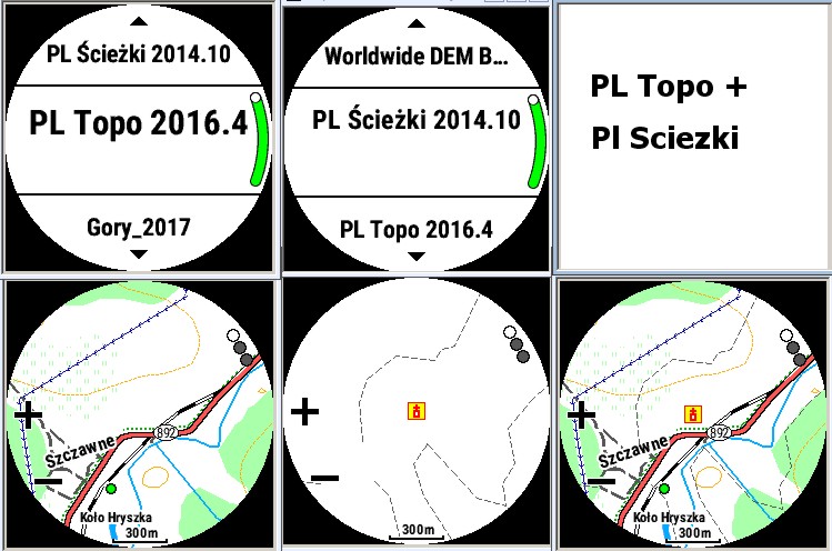
    (I apologise for my English)

    I am confirming:
    1. Yes
    2. A few clicks in settings
    3. Yes

    "PL Ścieżki" - transparent map

  • (I apologise for my English)

    I am confirming:
    1. Yes
    2. A few clicks in settings
    3. Yes

    "PL Ścieżki" - transparent map


    Thank you / Dziękuję Ci!
  • So, can anyone confirm that the Topoactive maps on the UK 5X don't have contour lines? If this is the case I take it I'd need to buy the Topo version or install an OSM version? Fairly rubbish to spend £630 and not get a decent map for running!
  • The topo active map europe west inclouds altitude data in the map but with no visable contour lines (I own an European (German) version of the 5x).