Pre installed Map detail above 0.2 miles

Hi folks......

There seems to be sparce detail above 0.2 miles, making it hard to near impossible to find small towns etc in and around the country while browsing the pre installed Map. For instance I might be hiking and want a detailed view above 0.2 miles which is not possible now.

I have Frikart... Talkie Toaster ..... maps on the device with detail of villages and small towns above 0.2. 

I also have a basic routable OSM map for car navigation, and it also doesn't have much detail above 0.2 miles.... but more than Garmins pre installed maps. 

I just phoned product support, and they confirmed on the 5x plus they had there...that there is little detail above 0.2...and only the basemap is displayed.... they could see this could be an issue, and have passed it on the development team.

Anyone else seeing this or have any thoughts...

  • Former Member
    0 Former Member over 5 years ago

    Would using the Satellite Imagery map help? I bought the £20 per year subscription and use it overlaid on Frikart maps. Works well for me for larger scale views?

  • Yes it's great..... I've downloaded half of South Wales using Basecamp and Birdseye. . (not the fish fingers lol)

    I started using it on the 5x..

    I Overlay it with other maps as well.... It works really well...I find its most effective between 50 and 120ft zoom level.

    Because we don't have contour lines as standard here in the UK and Europe...  I downloaded a transparent contour map to overlay on any map I have without them... Like the pre installed maps. 

    But I still would like more detail on the pre installed maps above 0.2miles...for instance browsing other countries for small towns is now made much harder. 

  • Former Member
    0 Former Member over 5 years ago in reply to Sam201176

    South Wales and Astronomy. Mate are you me lol!  

    yeah I got the contour lines from another site as well...

  • Hi fellow countryman Lol..Flag black. : - ) 

    Trouble is there's to much light pollution....even in my small village only the brightest stars are visible.....30 years ago I could see the next milky way spiral arm... Ah well.. . Progress. : - ) 

  • Former Member
    0 Former Member over 5 years ago in reply to Sam201176

    I just head up onto Llangynidr moors which fortunately is pretty dark. But I do have a skint local authority that switches off most lights lol

  • Another country man here,the basic maps on my 5x plus are poor, , this time of year on some of my mtb rides I like to explore, and when I zoom in I have nothing, I know I live in the middle of nowhere, but surely it should have more detail, how can I get more detail, footpaths, trig points, do I buy the talkytoaster maps, garmin told me there birdseye for £20 how much of wales can i get for that ?, i want to learn to use basecamp, and plan routes and have turn by turn on my watch, and maybe an edge unit in the future. 

  • Former Member
    0 Former Member over 5 years ago in reply to xv1234

    With the satellite imagery you can have I think about 3000sq km at a time, but what you can do is download the area's you want and swap out as needed.

    Talkytoasters maps are good, as are the frikart.no maps (http://www.frikart.no/ are free)... I use the frikart maps at the mo

    EDIT: No I'm wrong, it's unlimited

    https://buy.garmin.com/en-GB/GB/p/70144

    We’ve made it even easier to transfer high-resolution satellite imagery to your GPS handheld device to get a true representation of your surroundings with a 1-year subscription to BirdsEye Satellite Imagery.

    Use your BirdsEye Satellite Imagery subscription with BaseCampTm to quickly transfer an unlimited amount of satellite images to your device, with frequent updates, and seamlessly integrate those images into your handheld’s maps whenever you need them.

    • Images updated frequently for greater accuracy. Plus, the download process is optimized for smoother, faster updates.
    • Captures the world in brilliant clarity and detail with high-resolution sub-meter color satellite imagery.
    • Allows you to layer vector maps on your handheld (such as TOPO 100K, TOPO 24K or City Navigator®) with BirdsEye Satellite Imagery for a real-life view of roads, buildings and terrain.
    • Makes it easy for hunters to perform preseason scouting, determine placement of stands and locate game pinchpoints.
    • Helps hikers and campers find trails/trailheads and clearings for camping areas.
    • Lets geocachers determine the terrain type around a cache and identify parking areas close to the caches.
    • Allows travelers to view tourist hot spots and landmarks from an aerial view to make excursions memorable without getting lost.
  • Former Member
    0 Former Member over 5 years ago in reply to xv1234

    also as a mountain biker, these may be more up your alley

    https://openmtbmap.org/

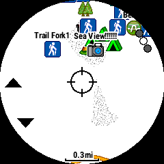
  •   The first screenshot is the Garmin pre installed maps....hardly any detail above 0.2 miles

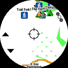
     second screenshot is a basic OSM car routable map...that has slightly more detail.
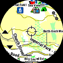
     third is Frikart......much more detail.

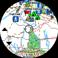
     fourth map is Talkie Toaster...

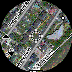
     the last one is just a bonus screenshot of birdseye overlayed with another map.. the satellite imagery looks better on the watch... than it does in this screenshot. 

    just thought i would show the differences in the first four...also  the Frikart and Talkie Toaster maps have tonnes more information when zoomed in.. .compared to the pre installed maps. 

  • Thank you, so much information, I was out the other day , I wanted to find a path, and then a big telecom mast which can be seen 20 miles away, just to get my bearings, not on the standard map, also the names of the summits, not on the map, I live by the offas *** path, at least that is on there. But thanks again. I did try the talkie toaster free map on my first 5x plus, but maybe it's worth trying the frikart ones.