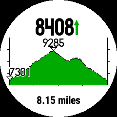
I ran a course I uploaded yesterday and all the elevation data seemed accurate however when I look at the elevation plot, it is way off. Viewing the course plot on the watch during the activity it shows a starting elevation of 7301' and max elevation of 9285'. However it shows an ascent of 8408'! The true ascent was 2133'. The climbpro vert was also way off. I assume the GPX data is bad.
What would be the easiest way to calibrate the correct ascent numbers in the course? I can't find a way to view the actual GPX ascent data points outside of the watch. Also, I assume that the ascent and climbpro data can only be ran from the initial GPX data and not the actual map from the watch?