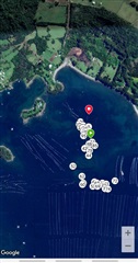
GPS connection in Apnea Hunt Mode

I mostly use the MK1 when spearfishing and I would like to know how you freedivers and spearfishers gets as much GPS tracking as possible.
I mean when I return to shore and gets out of the water, I normally only have 2 GPS points: the start- and the endpoint of the trip.

My questions are:
1) Have you changed any GPS-settings for the Apnea activity to get the fastest possible GPS-connection?
2) Do you lift your arm sometimes during surface-time to get some GPS tracking or do you manually save the location(GPS connection is still needed)?

  • Hi there, the start (green) and finish (red) markers will always appear on the spearfishing activity details afterwards. 

    Regarding additional markers on the map, this is what I usually see:

    1) Individual dives: represented as numbers in white circles. These will only appear in the map if you happen to raise your arm out of the water, and the GPS acquires signal (it does it automatically, and your watch will vibrate if this happens). Otherwise, the individual dive won´t appear in the map, but it will show up on the list of individual dives in the activity details in Garmin Connect. You can see depth, lenght, bottom time, surface interval, and GPS location of each of these. Sometimes I stick my arm outside of the water on purpose, to get those details for that specific dive, but most of the time I don´t.

    Regarding GPS settings, I have both GLONASS + GPS enabled

    2) Waypoints: these only appear if you explicitly place them. I usually place/mark waypoints to pinpoint interesting spots (either a rock, cave, etc). I used these in Garmin Explore, in order to measure distances, see patterns, etc, on a kind of "google maps" that the app provides.

    Hope this helped!

  • Thank you, Baba!
    I guess I just have to raise my arm to get a GPS signal when I do turns, if I would like to have a better track...