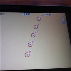

Those are nautical aids to navigation. Red fixed lighted day marks. No idea where or why yours are showing up. I have the nautical charts on my 700i which I purchased separately.
Thank you for the information. I did purchase nautical charts for my Garmin as well. I will continue to tinker with my Montana 700. Thanks Again
I think I was able to replicate it. If for example I use “driving” profile, street maps automatically are used. However, if I click the menu from the map page (three bars in the lower right) choose map setup, configure maps then enable all the nautical maps (there are five for US and Canada) I get nautical map features showing up on the street maps. At the top of that list is “automatic maps” which should be enabled. As such I will only get street maps in driving mode and only nautical maps in marine mode and Topo in recreation or hiking mode.
They are gone!!! I followed your instructions and these icons/symbols do not appear in the middle of nowhere anymore. Thanks again for your assistance. Much appreciated.