M3+ Ultra Marathon Tracking

Has anyone used their M3+ to track an Ultra Marathon or equivalent so their crew can follow them in areas with no cell reception and see their location on a course? if so how well has it worked? I am looking to upgrade from an old M1 which really didn't work for this as the course would not show up on a mobile browser and it would only show a dot on a map and wondering if the updated software that I could not use on the M1 works any better?

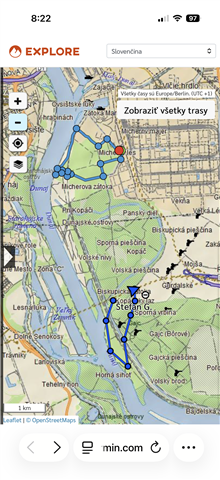
  • Hi. Currently, Garmin shows the route traveled on the map like this, the location update is every 10 minutes. The problem is not with the device, but with the topographic map used by the company. Just for comparison, I am attaching the route from the ZOLEO device where the location update is every 6 minutes.

  • Thanks, will it show the route traveled against a route you have created ? I want to be able to load the course map and show where I am against the course map so the crew can easily determine how far away from a checkpoint I am, the issue previously has been they can see where I am but on a mobile browser (phone) but it would not show the pre planned route only the the path traversed to date so they have no easy reference to see how far I am from a checkpoint as the created route would not show up to be overlaid on (even though it works on a normal browser)... hopefully that makes sense ?

  • In theory, GARMIN allows you to upload a route via the Explore application and then display it on the map, but I'm afraid that this is only for the owner of the given account and that it will not be displayed via livetrack or mapshare. You should contact GARMIN with this question.
    I asked AI and he gave me this answer:

    To display a pre-planned route on your Garmin MapShare page, you must ensure the route is saved in a Collection that is specifically enabled for MapShare visibility.
    Follow these steps to set it up:
    1. Sync Your Route to Garmin Explore
    MapShare pulls data from the Garmin Explore portal, not Garmin Connect.
    Log in to the Garmin Explore web portal.
    Go to the Map tab and either create a route or import a .gpx file.
    Save this route into a specific Collection (e.g., "Pacific Crest Trail").
    2. Enable the Collection for MapShare
    Even if a route is in your library, it won't appear on your public map unless you authorize it:
    Click the Social tab in the Explore portal.
    Ensure MapShare is turned On.
    Click Filter MapShare Data (or "MapShare Settings").
    In the list of Collections, check the box next to the Collection containing your planned route.
    Click Save Changes.
    3. Verify on the Public Map
    Open your unique MapShare URL (usually ://share.garmin.com).
    On the left-hand panel, look for the Library or Collections icon.
    Ensure the eye icon next to your specific route is active.
    The planned route will typically appear as a thin, solid line, while your actual tracked progress (the "breadcrumb trail") will appear as a thicker blue line.
    Troubleshooting Tips
    Active Collection: On your handheld device (like an inReach Mini 2), ensure the Active Collection for recording is the same one you shared on MapShare.
    Date Filter: If the route isn't showing, check the Date Range filter on the MapShare page; sometimes it defaults to only showing data from the last 24 hours.
    Do you need help importing a GPX file into the Explore portal, or is the route already saved in your library?

  • I tried it according to the instructions from AI and it works. It shows the planned route and my current route.