Mapshare High Definition Tracks

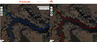
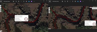
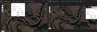
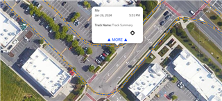
Recently got a Mini2 and can't figure out how to get the high definition tracking to display on my mapshare page. I can see the high def route on my Explorer page map, but on mapshare all that is displayed are the 10 minute send interval points with straight lines between them. Any way to fix this?

(I'm coming from using the original Inreach Explorer and that was pretty straightforward and easy in getting high def tracks to post with a simple sync.)

  • The “logged points” (what you call the high definition tracking) are not sent by satellite. You must sync the device in order to get logged points uploaded. Newer devices, such as M2, do not support wired desktop sync. For the M2, you must sync via the Explore mobile app. 

    That said, if it appears on the map tab at explore.garmin.com, it should also show up on MapShare. What exactly do you mean by “my Explorer page map”?

  • Appreciate the reply and thanks for the patience as I learn the terms.  What I was calling "my Explorer page map" is the same as the what you called the map tab at explore.garmin.com.  After syncing in the Explore app, while I could see the the high detailed (I was previously calling it high definition) on the map tab, it was not showing on my mapshare and could only see the 10 minute interval, satellite sent points. 

    What I have learned from playing with it a bit more is that the Mini2 doesn't use logged points in the same way as my previous Inreach Explorer did (and from further reading the way the older Mini1 did too.)   Logging points that were part of "tracks" on older models are called "activity" on the mini2 and to see them on mapshare, you need to specifically select that you want to show activities.  To clean up how the mapshare looks with the Mini2, after syncing, I turn off viewing the tracking points and only display the high detail activity.

    While it works, I miss the old logged points because after syncing they would auto update the satellite send track to show the higher detailed track.  The logged points were also nice, because while in mapshare, people were able to click a point and see what time I was at a specific location.  The high detail activity tracking  (as far as I can tell) doesn't offer that and just shows the overall activity trip start/stop times.  Adding a screenshot of side by side mapshares for both the older inreach explorer (Left side w/logged points) and Mini2 (Right side w/high detail activity tracking) from a portion of yesterday's trip.

    I'm always looking to learn, so open to any suggestions, comments or tips.

    Thanks again!


  • Actually, I'm not entirely sure about this. Garmin is trying to "unify" all of their handhelds and wearables. This means that all the newer iR devices (including M2) now record "logged points" as activities.

    Prior to the introduction of this "feature", the explore web site did a tolerable job of combining the sent points and the more detailed logged points into a single path on the map. The path followed the more detailed track. The sent points appeared as circles on top of the detailed track. The web site suppressed the straight lines connecting the sent points. To be fair, this did not always work - but it did work most of the time.

    I suspect that when you say "clean up how MapShare looks", you mean that you suppressed display of the sent points (to eliminate the straight lines).

    Regardless, I think you will find that if you click a point on the more detailed track line (activity line), you WILL see the date/time at that point. At least, it works on some old tracks which I have available. 

  • Yes, by cleaning up the view, I meant eliminate the straight lines.

    As far as I can tell, on mapshare the M2 displays the activity line as a continuous line (no individual points visible as the older systems had.)  Regardless where you click on the activity line, the only info displayed is date, full (complete) activity track start/stop time and basic info like distance and speed.  Granted, I could make the tracks visible again which would at least give me the ability to see info at each satellite sent point, but along with all the straight lines between points being visible, they are gapped too far apart (10 minute minimum) to really be useful enough to be considered high detail.

    While I agree that the old system wasn't perfect with combining sent and logged points (and eliminating straight lines), it worked 90+% of the time and was more user friendly.  By combining both points into a single track, viewers of my mapshare were able to click either a sent or logged point on the detailed track and see what I consider basic info such as point coordinates and time I was there.  Unless I'm missing a setting somewhere in mapshare (or on the M2), this "newer" high detailed activity/tracking almost seems like a step backwards in capability.

    Here are a few pictures of what I see on mapshare for both my iR devices.  The top photo has side by side screenshots of the M2 activity track clicking on different areas of the line.  Bottom photo is the older Explorer device; again clicking on different points along the track to display point info. 


  • Here's what mapshare with the M2 looks like with both tracks and activities visible.  This is the only way that I can get "any" points to be visible for viewers to click on for additional info.

  • Hello Coming from an explorer+ you had log intervals that could be set lower, and send intervals. However with the mini 2 you have the send interval which goes directly to mapshare via satellite, and then your activity. Activities will show on mapshare after you sync the device or on the map page of your explore account but under activies instead of tracks. What are Tracks, Routes, Waypoints, Activities, and Courses on Garmin Outdoor Handhelds?. You can also see Getting Started With Tracking on an inReach Mini 2 it may help explain the tracking with the mini 2. It will also be beneficial to see Library and Collection Data Not Seen in MapShare.

  • Hi.  I've read everything and understand the difference in log and send intervals, tracks and activities but my original question/concern is why aren't the breadcrumbs that are used to create the high detail activity on the Mini2 visible on my Explore App or on mapshare?  Your reference material states that high detail activities use breadcrumbs to create the "line", yet they aren't visible on maps as they had been on the older explorer handhelds.  Knowing the breadcrumb info (time/location/elevation) is a great resource when reviewing a previous trip and sharing via mapshare.  As I mentioned in an earlier reply, removing this feature from being displayed (which is technically still there in the breadcrumb code that the high detail activity line is created from) is a step backwards.

  • Update...

    I returned the Mini 2 and picked up an original Mini.  It uses the older Earthmate app and displays the high detail tracks on the Explore account map and Mapshare with all log points visible.  From a tracking standpoint only, it is superior to the M2's activity tracks.


  • Surely older Garmin devices can’t be better than new ones, or can they? I often wonder why I updated.

  • Are you really sure that it wasn´t perhaps only a setting problem on your Explore/Mapshare page?