Too many points being calculated

Next question.

If I take a trail from alltrails save to my computer as a GPX file, then drop it into Explore (import) then sync to my phone and to my 66i. All good so far. 

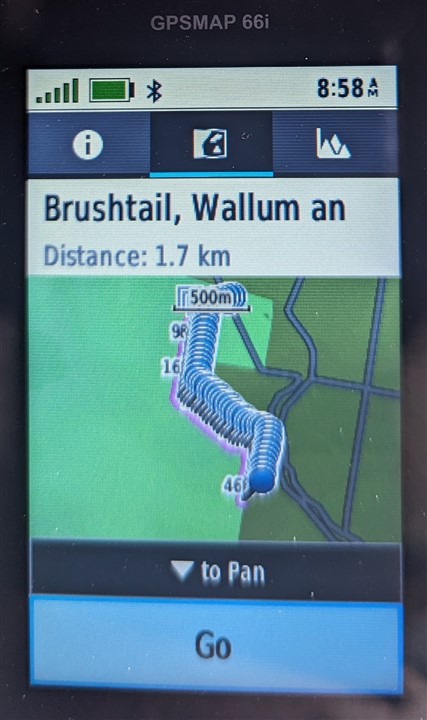
But I then review the trail and find it has hundreds of points in the data and showing on the unit display. It seems to have placed a point every few metres which is nuts and not required. 

Am I doing something wrong, or can I turn some setting off?
  • Most likely the file you downloaded wasn't a recorded track (points recorded periodically on GPS while someone hiked). It was likely a route (someone drew lines on a mapping website for the intended hike). You could try to import as a Route in Explore Website and then synch to 66i. Then covert the Route to a Course, and then convert the Course to a Track. It might work or maybe not.

  • Phew, that seems an extreme process.

    But thanks for the suggestion. 

  • I sorta tried what you suggested, but was able to convert directly to a track within Explore, then syncd to 66i. 

    So I now have a track, that looks like I think it should. 

    I truly thought I was buying a straight forward navigator with Sat SOS & comms ability. The latter is correct, the former anything but! 

    Thanks for the help. It's truly appreciated. 

  • Actually, I think the result you have is the expected result. Maybe not what you WANT, but the expected result. Typically, what you download from AllTrails IS a recorded track. Depending on the settings on the device which recorded the track, there could well be a point every few meters. 

    If what you want is a route/course/thing-du-jour, then the rest of this thread describes the proper process. 

  • Good. I should have instructed you to convert within Explore rather than synching first. It should work either way, though. 

  • Just had a look at the Brushtail track you downloaded, and it has a waypoint every 4 meters including in straight lines so appears to have been recorded at that fixed ground interval which is excessive and unnecessary for this use case. It's better practice to record using a devices "auto" setting to capture only significant changes and reduce complexity so don't feel bad about the 66i, it's doing its best with the bad data it's been given.


    Another option is to reduce a GPX track on your computer with one of the many apps that can do it including for example Garmins BaseCamp (or MapSource) and simply "Filter" it. Other applications that do it sometimes refer to the function by another name such as "Simplify" or "Smooth" but it's all the same quick & easy standard process for exactly this common issue. 

    With BaseCamp you can then also then simply transfer the reduced track directly to the 66i and it will show up in Saved Tracks.

  • I shall try that. I probably sound like a right whinger, I don't mean to. Just frustrated.

    I think part of the issue is that Garmin has a multitude of different programs, Basecamp, Connect, Connect IQ, Explore etc, and the web versions work differently to the app versions, and different programs are compatible with different devices but not in a logical or seamless way. It's almost like they let a programming madman loose and let him go willy nilly. 

    Today I went on a walk that I had personally drawn using Explore and topoactive maps in a local conservation area to me. Half way around I came to a junction of tracks and, pulled the 66i out and found the track had disappeared, no track, no blue arrow! After a while I turned the unit off, and back on, hit 'find' 'courses' & on the course I was doing. It downloaded the points once again and was all good. What's with that? Plenty of sky view so is this a common occurrence with Garmin navigators? 

    Ok, off to try your suggestions lol. Rofl

  • If you want to do anything practical or serious use the traditional applications like BaseCamp or similar. The newer mess of Garmin phone related apps are more about social and "look at me" self-gratification.

    The 66i behavior you describe is unusual, never experienced or heard of that. Could your screen have been scrolled across through pressure on the rocker button? If so Quit button will get you back.

    Garmin hardware is generally very good, I've a number of devices used for multiple activities in extreme environments over many years and they have been bullet proof and are still going strong. The only exception is our Aus variant of the Rino 750 which has had significant hardware issues since release that Garmin can't/wont fix.

    The 66i is fine, other than be wary of firmware updates which can be problematic. I would wait at least a few weeks and monitor feedback before accepting anything new.

  • It gets even more kooky and frustrating depending on what you're doing. I recently upgraded to a single device, the 66i instead of the old eTrex and mini combo. I used to pull a track into basecamp, convert to route, set all of the points to "shaping points" and then leave a few to alert like the one mile, two mile, etc. points just to let me know how far to next. Or set the half way or turn back so that I knew how far, etc. NOT on the 66i. Even though you set shaping points in basecamp, they ALL alert. So like every 50 to 100 feet it's bleeping and buzzing. So I tried clicking the "send to Garmin" button on Alltrails. That sends a course to Connect. Then you sync. It works for navigation, but it doesn't allow you to add points for alerts without dropping waypoints. It also doesn't show the course on Garmin Explore. It shows it exists, but you can't see it on the map. Long story short, it's all goofed up, and less feature rich than the several decades old devices, which makes no sense. What I finally ended up doing is convoluted, but sort of does what I used to be able to do. D/L a track into Basecamp. Convert to a route using NO more than 200 points and set all the points as shaping points. Send to device. Once on the device DO NOT open it or it won't work right. Sync that to Explore on the phone. In explore, save it as a course. Sync back to the device. On the device, edit the course and change the points you want to alert. (you can't do this on the phone BTW, which is silly.) They are in a long list so you have to know which number you want and scroll while counting. Big pain in the ***. Why are there less features on this device, which is newer than the decades old tech? How hard is it to just have Basecamp set the points and then transfer them properly? Or Garmin Explore, or Garmin Connect? The documentation mentions them all but they all act differently and none of them do what you want? There are dozens of features that don't work properly anymore, like distance to next, time to next, distance to point, turn alerts or point alerts that don't work properly or are a super hassle to setup. Why not just dumb it down to just a track on the screen that you follow and cut the electronics in half, save the battery and charge a 1/3 of the price.