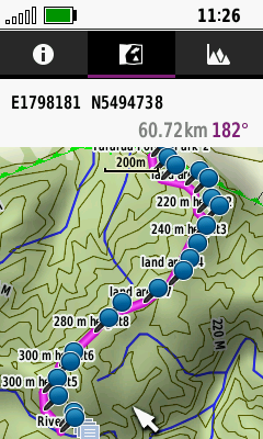
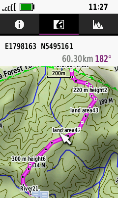
Turn off display of route markers...

I have made routes via Base Camp. In Base Camp the route "points" are effectively dots and the route is visible.

On the GPSMAP 66i these dots become pins that at many scales completely obscure the route.

Can their display be turned on/off or reduced in size?

If not, I'll put in a change request.

- Carl Knight.

  • Most users simply use a much smaller or invisible custom waypoint symbol for the blue flag/blue pin.

  • So on my GPSMAP 66i, how do I do this?

    Viewed as a Route, the pins appear. Saved as a Course and viewed, no pins appear. It's exactly what I want from a route.

    Route

    Above. The route as it appears on my GPSMAP 66i

    Convert the route to a Course.

    Course

    That is what I want for the display of a route.

    So how do I make that built in blue pin smaller/transparent, etc. for a route on my device?

    Thanks in advance.

    - Carl.

  • Turns out, that the course appearing without markers is a side effect of making a course from a route. If you make a course instead, it has markers like a route. Inconsistent at best.

    Regardless, getting something like the course without large markers for a route and vice versa is the goal.

  • I don't have Basecamp, but here's what I think the problem may be. A "route" is typically defined in the hiking world as a planned path one intends to take. It is usually a highlighted path on mapping software or a mapping website. A "route" in the automotive world is the path provided for you by the GPS software based on your destination input. The hiking route is passive navigation, the automotive route is active navigation.

    I think you're using the Basecamp route (hiking) and then sending it to the 66i as a route (automotive). 

    A quick fix that might work is to synch your device with Garmin Express. I don't know why, but it has removed pins for me in the past. You could also, after saving the Route as a Course, convert the Course to a Track. The saved track represents a saved hiking route.

    What you really want to do in the future, is export the Basecamp file as a track, not a route, if that's possible. If not possible, you could try to import the Basecamp route into the Explore website, but do so as a track.  Then, synch the track to the 66i.

    If you actually want the active navigation of the 66i Route Planner, then you are stuck with the pins.

  • I don't ever use my device for "automotive" activities. Only "tramping" (as we call it in New Zealand, "hiking" for the rest of the world - go figure! Slight smile). In BaseCamp all my routes and tracks have the recording activity type set to "Hiking." On my device, the default profile is set to "Hiking". If I look at the routes/tracks on device, they show as "Hiking" when viewed in BaseCamp.

    Courses don't seem to have an "activity" like routes and tracks.

    Then tracks, whilst they can have more points (i.e. a more finely grained "breadcrumb" trail), and display without the dreaded pins, when used in the field (empirically determined) if you go passed a track point when navigating, the GPSMAP 66i does not reroute to the next point like it does for courses and routes, and insists you go back to the missed track point!!

    I think it's time to make a change request.

    Thanks to all for responding.

  • Garmin does a terrible job of explaining the device. There are basically 3 sub-devices (4 if you include the satellite communication) within the 66i. There's a hiking GPS, a fitness watch GPS, and smartphone like apps (including the Route Planner that works like a smartphone or automotive GPS).

    Courses and activities come from the fitness watch world. They are FIT files. A course is the path planning tool for an activity.

    In the hiking world, a route was the path planning tool for a hike. A track was the recording of data as one hiked. 

    The Recording Controls act as a track recorder if you convert the saved file to a Track from an Activity. You can also download hiking "routes" from websites, but save as a Track.

    The Route Planner is best used with POI's, as automotive GPS's often are.