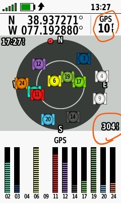
What to the red-circled length measurements represent in the 66i (ver 9.20) screenshot below? One of the length measurements must be the calculated horizontal accuracy. Which one? And what is the other one?

What to the red-circled length measurements represent in the 66i (ver 9.20) screenshot below? One of the length measurements must be the calculated horizontal accuracy. Which one? And what is the other one?

definitely failure of the support. correct answer would be: I have no information on that subject currently, but will investigate this matter for you
We can only assume that this is just the simple horizontal precision information to keep you happy. and will only jump around if you have really too many let say reflections, multipath or what ever temporary error sources.
More interesting would be also how for example speed is compensated for when the unit is moving. Meaning when you move, you screw up your beautiful precision result as your next fixes are definitely out of the previously calculated precision circle. Clearly devices manufactured for fast movement have to deal with it as approved marine use devices, but those small hand helds?
what did you use to product the scatter plot you posted?
For that I used Global Mapper
My guess is that the lower one, 304 ft., is elevation.
it is the gps elevation, the other elevation based on pressure etc is then under altimeter
As a comparison here's the results of another 6.5 hour test at the same known point this time overlaying 66i post-processed RINEX data in orange over the previous test plot.
In this case matching the devices 1 second RINEX logging interval resulted in 23,402 points with 95% falling within a 19 cm radius of the control point.
