How to get a map that includes the trails

This may be a beginner question so apologies in advance, I took time to search the web and the forum and look at similar topics, spent 4-5 hrs on this, but I still felt it would be helpful to ask this directly from the more advanced users so I appreciate your help.

So I went hiking a certain trail and I was going to use my Garmin Fenix 6 watch for navigation, but that trail system or the nearby campgrounds (which are even present on google maps) were not shown on my watch's map, even though I could see them on the online connect.garmin.com map.

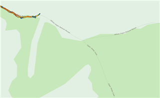
Here is a screenshot from connect.garmin.com if you activate the "HERE" map:

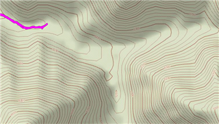
Here is what you see in the watch, using Garmin's TopoActive:

So thinking that I could get the trail system if I buy a Garmin GPS unit, I bought the GPSMAP 66i, only to find that (correct me if I'm wrong) it doesn't come with anything more than the map that I had on my watch! No trail system (in this area) no campsite no Hotspring nothing! Just a topography map.

Upon searching this forum, I found my way to explote.garmin.com, where on the "map" tab, if I activate the "Topo" option (not "TopoActive" option) I will get this:

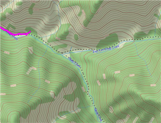
which as you may notice, includes the trails, but not the correct trail names (compared to the "HERE" maps)

So here are my questions:

1. Is this last screenshot, what I would get if I pay for the 100$ Garmin 1:24 maps? I should ask this because I didn't find any way to check the map (to see if it includes the trails I'm looking for) before I buy it.

2. Is there any way to get those "HERE" maps on the device? (the first screenshot)

3. (most important) this is expensive! I live in Boise Idaho. So If I want the Idaho map I should pay 100$ to get the North Central map. If I want to drive 1 hr west or south to hike there (which I do) I should pay another 100$ to get the West map. If I want to drive 4 hours southeast to hike or backpack, I should pay another 100$ to get the southwest map. Take a look:

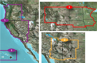
That is 300$ just for maps for my 4hr drive radius, on a 600$ GPSMAP device that I thought should already come with better maps. And from what I've read here and there, those 1:24 maps are spotty and old, and may include or not include many trails. So my question is this: Is there any better (cheaper) way to load reliable trail maps onto this device, or get a device that comes with better maps? What are the more advanced users doing!?

  • No matter what maps you buy/use, NONE of them will have every trail. Even if the trail appears, it might not be accurate. For example, public-domain USGS topos show a lot of trails. Unfortunately, they were surveyed 10's of years ago and weren't very accurate to begin with.

    You are already on the right track with AllTrails. AllTrails and similar crowd-sourced sites often have contributed tracks from users who hiked the trial recently. Just download those tracks to your device. Look for the .gpx file format. It's not always that simple, particularly if you want the result to routable. But it's really the only way to get accurate trail data. Note that AllTrails is not the only possible source.

    Yes, you can get data out of connect.garmin.com and onto your device. The last time I did it, I exported to .gpx and used that. That was not straightforward. There might be a better way, but I try to stay as far away from Connect as possible. It is, however, another place to get crowd-sourced data.

    Another possibility is OSM topos. I no longer know of a good source for these. A lot of sources require you to turn handsprings to create maps that work on Garmin devices. But OSM maps do show a lot of trails.

    You can also try gpsfiledepot.com. They have contributed topos for every state. Quality and content varies considerably by state. But they are free and available in Garmin format.

  • I've tried a few options and much prefer the Topo US 24k when hiking in the US. Expensive but the amount of detail is great, come with a built in DEM for all the topology features and are routable. So far I haven't yet encountered any missing tracks and worth it for me.

    The current Topo US 24K North Central - West (V3, 05 Dec 2016) has both tracks on the Sheep Creek & Sheep Creek East Fork in your example.

  •  Thanks for taking the time to check this trail on the Topo 24. It seems like the explore.garmin.com topo map is the 24k map they are selling.

    The interesting observation is if you look at the DEM map (my first screenshot), the correct name of the trail is used, which is "William Pogue ..." trail. But Garmin doesn't have the right name for the trail, it shows the name of the creek instead, but on the other hand, it shows some other trails that are not present on the DEM map.

  • I appreciate your comment. Now I have a bunch of threads to follow. I'll try to look for the USGS topos, they seem old but they did have some of the trails that I'm looking for.

    I like AllTrails but the problem with the crowd source tracks is that you can only see the track of the person who recorded it, not the whole trail system. For example, in the link I provided in my first post, the track suddenly ends in the middle of nowhere, and before going there I couldn't know if I can continue it or not, if so where does it lead to, or can I find another trail that circles back instead of coming back the same way, etc.

    Another thing is something you are following a track, but something unexpected happens and you want to find the quickest way to go back or change your way. In this scenario you need a map/device that works offline and includes the whole trail system of that area, not just the track that you wanted to follow.

    For sending tracks from Garmin connect to the GPS device, have you tried this: In the mobile app, open menu, then Training, then Courses, now open the course you want, then menu (the 3 dots in the corner), then "send to device", select the device you want and done. I haven't done this with the GPSMAP unit yet, but works smoothly with my watch.

  • Your sample trail is a very good example of the various map nuances.

    AllTrails describes the William Pogue as "The William H. Pogue National Recreation Trail (#122 or 122001), also known as Sheep Creek Trail".

    The AllTrails William Pogue track download only runs a the first few miles of the network and doesn't show any of the side trails. But it does reflect what appears to be a later and more significant reroute of the sheep creek trail for the first section of the Sheep Creek valley.

    Both tracks, the Sheep Creek Trail on the Topo US 24K and the William Pogue, can be seen in Google Earth.

    Here's the William Pogue track gpx download over the Topo US 24K:

    William Pogue from trail head:

    Sheep Creek from the trail head:

    I'm with twolpert and stay away from connect and anything else trendy and finicky. OK in town when you can stop at a coffee shop and figure things out when they don't add up.

    But if you're heading into the wild you want something reliable with as much detail onboard as possible to be able to make your own interpretations and decisions as the circumstances demand. No map data is ever up to date, it's already obsolete before it's even published. So learn the basics, same as a paper map and carry a backup, your watch or paper.

    Any other details are the cream on top but don't get hung up and be open minded with them. Learn to read the land and develop your own basic instincts. The tracks will change but the landscape doesn't so if you are heading the right direction up the valley.....you are probably heading the right direction up the valley.

  • the images are interesting, on the google map seems like the William Pogue trail and Sheep Creek trail are two distinct trails, hmm Thinking

    thanks for the tips. I'll keep these in mind. but still, having to pay 300$ for the maps of my surrounding areas is really frustrating.

  • The Open Street Map maps are quite good. There are plenty of sites explaining how to get them and install them.

    If you want US maps, this is where I get maps for my 66i:

    www.gmaptool.eu/.../usa-osm-topo-routable

  • Thank you. Big chunks, but certainly beats building the Garmin-compatible maps myself.

  • Here's the OSM over the sample trail area that gives an idea of the differences in the detail.

    It is free and does have a DEM but only shows the first 1.5 miles of trail as a "Footway" and no more, and doesn't include most of the other trails or Sheep creek or other waterways.

    On a lesser note the OSM contour processing is coarser so visually jagged and the height differences between the DEMS in one spot was 80ft.