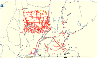
Cannot display ALL tracks on GPS map

I have uploaded 3000+ tracks in GPX format into basemap and then onto my GPS. I want to display these tracks on my GPS map, all tracks loaded successfully but it appears that the only way to display them is individually? I have 3000+ tracks that I need to load onto 5 GPS's, I cannot individually turn all of them on. How can I turn ALL tracks on to view on the map on my GPS?

  • I'm not sure what you're asking. Can you describe the steps you are going through to make a single track visible?

    Separately, what is your use case for this? If the all the tracks are in the same vicinity and you could see them all, the map would probably be cluttered to the point of being unusable. If they are widely separated, what is the point of being able to see them all at the same time?

    In general, the unit has "restrictions" like this in order to be able to render the map quickly when you are in motion. And to avoid sucking up lots of CPU (and lots of battery) trying to render more stuff than necessary.

  • Hi, thank you very much for your response.

    To make a single track visible I do the following:

    1. Open saved tracks
    2. Select an individual track
    3. Click the menu button
    4. Select "Show on map"

    My use for displaying these tracks is to display roads that are more likely to have landmines (i.e. generated from a risk assessment). We have rated our roads as green (safe), yellow (moderate) and red (unsafe) when it comes to landmines. I work in an area that is extremely remote and we use our GPS to navigate. Below I have included the view I have on Basemap which I would like to mimic on my GPS map. It seems a bit blurry below but I hope you get the picture

  • So you just want the data displayed - no routing or other navigation ability? If that's the case, you might look into creating a Garmin "custom map" from the image. That said, I'm not sure I'd trust the geo-registration to be adequate for your purposes. 

  • Garmin doesn't make a GPSr that will display that many tracks on the map at one time. Most are limited to 250 or less. Most will not index more than a few hundred, or maybe 1000.

    What model GPSr are you using?

    If a GPSMAP 66i, the limit is 2000 total tracks loaded, and only 250 can be displayed at any given time.

  • Thank you. I've taken a different approach to this problem now and am trying to convert my GPX file (3000+ tracks) into a single track/GPX file. I havent had any luck in this regard - I've tried Arc Pro, Global Mapper but am still struggling. Have you ever done something like this?

  • Even if you succeed, I don't think the result is going to be what you want. The tracks in the image are disjoint. When you connect them all into a single track, the endpoints of "adjacent" tracks are going to be connected. Also suspect you would have problems controlling the color of individual segments.

  • Yes, I have combined tens of thousands of tracks, each with unique details like trail name, type, difficulty, etc, all fully routable, into a single transparent raster map I can display on my Garmin devices.

    This process is slow and tedious, requiring many hundreds of hours to accomplish, and not for the impatient.

  • Just to clarify, the trick here is the raster map. It's not just a matter of connecting a bunch of separate tracks end to end.

  • Yes, connecting tracks end-to-end would not yield the desired result. 

  • An alternative is to create an overlay map. These maps are mostly transparent. 

    These can be vector graphs (faster than the raster approach).

    BaseCamp can’t use overlay maps with other maps but the GPS should be able to (my cycling GPS does).

    BaseCamp can display the overlap map by itself (but that is of limited use).

    You don’t want to display each separately. It will slow the display down a great deal.