I'm a longtime Garmin handheld user having owned one of the original eTrex models then upgrading to the Colorado series onto the 64st. I have now sold the 64st and got my new 66i yesterday. I did a search and didn't see anything this specific.
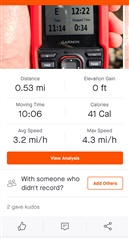
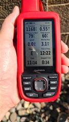
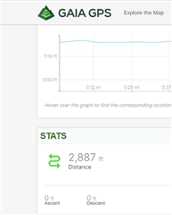
I created a route around my neighborhood via the GAIA GPS website. I saved it as a .gpx file. I transferred the file to the 66i. I brought up the route in the route planner on the 66i and pressed GO. I started recording. I was able to follow the route I created fairly easily and saved it when I returned home. I only did a short half-mile walk around our neighborhood. There was a very short elevation gain of approx. 60 feet. I sync my cycling and hiking activities to Strava. I'm assuming a few of you avid hikers use Strava or a similar activity tracking app. For some reason, Strava didn't acknowledge the 60-feet of gain indicated on my 66i. Didn't seem to have any issues recording the rest of the data, but for some reason - it omitted the elevation gain. Not a big deal for this initial test, but during longer day hikes with a couple thousand feet of elevation gain - I'm hoping this is factored into my recording.
Thoughts? Is it simply due to the minimal gain? Is it something happening (or not happening) between the GPX file and Strava?