This discussion has been locked.
You can no longer post new replies to this discussion. If you have a question you can start a new discussion

Approach Z82 Slope / Altitude Measurement

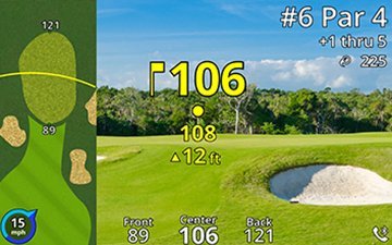
Hi. I just bought the Z82 quite specifically for the fact that all the text online and screenshots on the Garmin site show the device’s “plays like” feature is supposed to tell you the true distance, the plays like distance, and ALSO the variance in altitude (something I really need). As shown in the photo I’ve attached.

However, what my z82 shows me is the true distance, the plays like distance, but instead of also showing the change in altitude, it simply shows me the difference in yds between the true distance and the plays like distance eg if the true distance is 150yds and it plays like 160yds the third number would be an “up” triangle and “10”. As if I couldn’t do the basic math of 160 - 150 myself!? 

Like I say. I bought this to be able to tell the height difference between where i am standing and where I am aiming. Does anyone know why the z82 doesn’t seem to do what the pictures and descriptions online suggest it should?

Thanks for your help folks.

  • I had to return mine z82 because of the video issue but expect the new one to arrive soon, then i can test my hypotheses about your question.

    But for now i think it is as follow. Maybe you can try and confirm if it is like this.

    When you select the playslike future it show the distance and playslike distance with the triangle or squared dot and y/m. difference projected.

    This is NOT the height difference it is a calculated "golf club play" difference by formula using distance and incline/decline of the measured point your are aiming.

    This way you can use the distance info for easier club selection.

    When you do not have selected the playslike future you see the height difference without any calculations of how it playslike.

    This way it shows you what you want. The height difference as seen on the picture you posted.

    To disable the playslike function you have to select tournament mode. In tournament mode your pinpointer and playslike distance is disabled.

  • Hi, if I’m following you correctly, I believe I already tried this. When I turn off plays like (or turn on tournament mode) all I get is the true distance. No up or down arrow, and no extra numbers at all.

    And when I have ‘plays like’ on, it shows a true distance number with no units e.g. yds, and a plays like number, again with no units like yds, and finally an up or down arrow with a number but no units like ft or yds or anything. And that number always seems to be equal to the difference between the true distance and the plays like distance.

    Thanks for your answer, sorry if I am misunderstanding.

  • Ok, pity it is not like that.

    Maybe Garmin - Chris knows this. He also has the Z82.

    Btw, My new Z82 arrived minutes ago! Slight smile

  • The manual on page 3 says that you see the distance and true distance AND the smaller number below these two (should) show you the elevation change. Maybe the elevation change and true distance are similar at the moment of measuring? Maybe the function is not working as it should and  here is a bug.

  • Ye thats what I saw too. Hoping this is just a software patch that needs fixed. Hopefully someone from Garmin can chip in an idea. If not I’ll try the chat or phone support.

    Thanks

  • I tested it on the golf course with elevation changes and it is working, yesterday.

    To see the elevation changes you have to have playslike set to on. If not you only see the distance you are measuring.

    Coincidentally when the elevation is just like 1, 2 , 3 or 4 meters the playslike and elevation change is about the same and giving the impression that the small number below is this difference but it is the elevation like on the picture you posted. That is what I think is happening. Do not forget you measure the elevation from you eye height which is already, for me, around 164 cm. making the elevation even lower then it is from ground level to begin with.

    But when you aim to higher objects you will see the elevation changes below the distance and the playslike distance as expected. You will see there is calculated difference between it proving that it is elevation and not the difference between distance and playslike distance.

    I aimed at the top of a big tree at 66 meters distance. Z82 shows 66 meters distance, then below it the playslike distance up 79 and the elevation in small fonts below shows up 20

    I aimed at several higher top points of buildings, commercial flags, trees and it gave me the distance, playslike distance and the elevation in smaller font below.

    I also tested in the sight something mode and it behaves the same correct way. I also tested in play golf mode while i was in my garden with that big tree in it i mentioned above. It also showed the same three measurements.

    I think it works. Please try it like this and report back to confirm or not

  • Hey. Thanks.

    I spent while on the phone yesterday with support and I think I have cracked it. Not sure if it helped but I downloaded all the outstanding software and course updates. But that might not be the key.

    For me personally (and possibly you), by terrible bad luck, every time I tested it before I think I was standing in a spot and aiming at a spot where the range difference is exactly equal to the elevation difference. Obviously this is bad luck and confusing but when you test in more areas it does seem to change/work.

    But here is the key! They seem to have changed the elevation difference to yds or meters - not feet! This means it is much more similar to the number of the range difference. For example:

    the old way you might see a range of 152yds, plays like 160yds, elevation of ^24ft (this might also be affected by wind remember)

    the NEW way you might see a range of 152, plays like 160, elevation ^8. Obviously 24ft = 8yds Elevation. But can look like the range / plays like difference of 160-152 = 8! Nightmare.

    mostly it is the change of elevation from ft to yds that has caused this confusion. And I think it is stupid because it is less accurate than measuring to ft which is a smaller unit.

    i think Garmin made the change to clean up the display. So now all numbers are in yds, there is no need to display yds as a unit. So they just display the numbers alone.

    i hope this proves true for you too.

  • Yes, you are right. I got home after playing golf and testing the feature. I came to the conclusion it was not working like you mentioned previously also.

    But i noticed also there was a small difference in the numbers.

    But during golf i was really not focused on it.

    Then this morning i tried it in the garden and started to see it is working and came to that conclusion it is working but the numbers are sometimes similar due to the small elevation change.

    I am glad it is working since i received a faulty unit the first time. I tested the second new unit and it seems all is working.

    The device is really great and on another level of range finders units. 

  • Awesome. All is well that ends well! Here’s to shooting low(er) numbers now we know what’s going on.

    But if Garmin see this; please consider changing elevation back to ‘feet’ for greater accuracy than just  to the nearest yard.

    Can’t wait to use this properly now! All the best.